|
Home
Instructors
Schedule
Grading
Readings
|
Survey procdures
for a closed traverse
A closed traverse is used to measure an enclosed polygonal area
consisting of straight sides. The result of a traverse is a vector
model of the polygon, with angles and lengths as well as real-world
coordinates of the vertices of the polygon, and knowledge about the
error of measurement.
jump to Field
Procedure | Office
Procedure
Field procedure
- Form teams of three. At least one person on each team should
have taken ESRM 250 or have experience using ArcGIS.
- Make sure each team has a compass, clinometer, measuring tape,
and field notebook.
- Traverse the stations as indicated in the assignment
instructions.
- Take careful field notes indicating:
- Date, time, and weather conditions (including temperature if
you can get it)
- City and state (for magnetic declination)
- Crew members present
- Make and model of measurement equipment
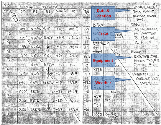
- A rough sketch of the area including station locations and
IDs
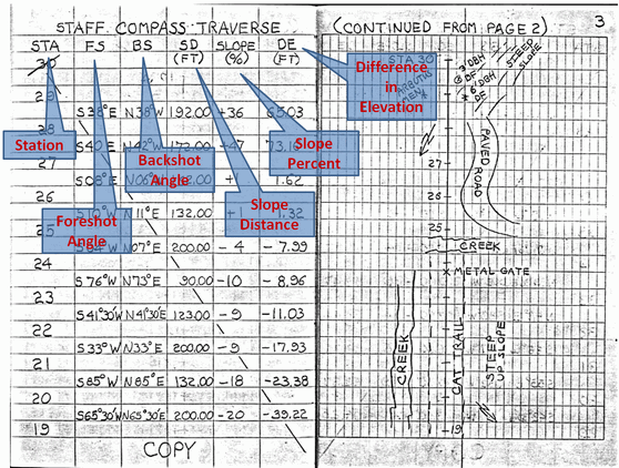
- Station numbers
- Foreshot and backshot (planimetric) angles using the compass
(as azimuth in degrees)
Note: the example below uses
quadrant bearings (e.g., S 38° E) but it will be simpler to
record the numerical angle from 0 to 360°.
- Slope distance from station to station using the tape
measure
- Slope (elevation) angles using the clinometer (in
degrees)
Note: the example below uses slope in %, but
it will be more efficient in post-processing to record in
degrees.
Do NOT attempt to collect difference
in elevation (it cannot be done using the equipment we
have)
The suggested method will be (assuming a start at station 1,
measuring to station 2):
- Two people stay at the first station (one to take notes and
the other to make measurements).
- The third person will take the numerically small end of the
measuring tape to the second station.
- Person 1 at station 1 will measure, and person 2 will
record:
- foreshot angle (as azimuth, i.e., 1° to 360°)
- elevation angle (as degrees; note + or )
- distance to station 2 (note: hold the measuring tape at
waist height at both locations, and
- The crew will move to station 2 with the compass and
notebook while person 1 stays at station 1.
- Person 2 will measure the backshot angle (from station 2
to station 1).
- Repeat the process until all stations have been visited (it
will be necessary to return the the first station at the end of
the traverse to record all necessary data).
A note about error in the foreshot and backshot angles: The
"perfect" sum of interior angles for this traverse of 4 stations
should be 360°. The maximum allowable error is k * sqrt(4), where
k is the smallest division on the compass (2°), therefore the
maximum allowable error is 4°. If the sum of your interior angles
differs from 360° by more than 4°, you can either remeasure your
angles (best practice) or distribute the error by post-processing
calculation (worse practice).
Office
procedure
- Correct for declination
by adding (or subtracting) the correction for each azimuth.
Magnetic north is east of true north in Seattle; should you
add or subtract the correction factor?
- Obtain
interior angles by calculation from foreshots and backshots.
- Calculate
interior angle error and adjust the interior angles, then
recalculate the azimuth of each line based on the correction of
the angles.
- Correct
the measured distances for slope
- Calculate
the latitudes and departures.
- Calculate
corrected coordinates for each point.
- Establish
(calculate) your error of closure (EOC) and precision.
- Calculate
the area of your traverse (use the coordinate method for this
course).
- Create a rough hand-drawn graph of the area indicating the
interior angles and distances.
- Complete the report (the
assignment).
|