FE 444: Harvest Setting Design Final Report
By: FE Seniors '98
Contents:
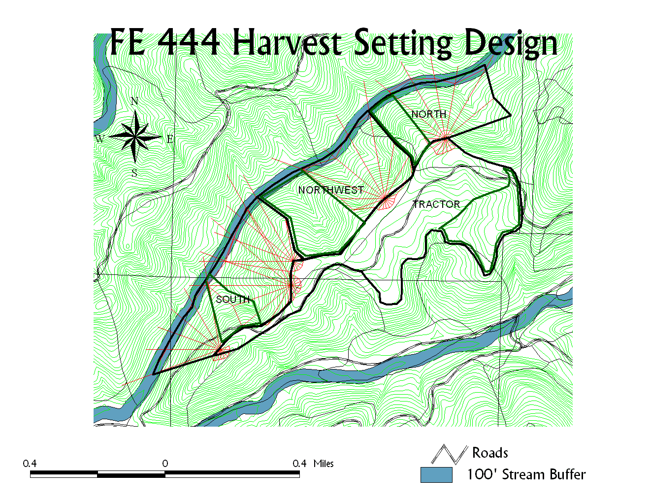
Retention areas are outlined in green.
(Right click on the image and select View Image to see a better image)
Identification of Sensitive Areas
Soil Sensitivity
In a harvest design, there are many factors that need to be considered when locating harvest and construction areas. Although the HCP provides a basis for these critical areas once must also identify soil areas sensitive to erosion. The Washougal basin contains varying topography, soil types, streams and timber areas. In order to complete this analysis we recreated maps and tables from the Soil and Mass Wasting layers of the FE423 Washougal Watershed Analysis '98.
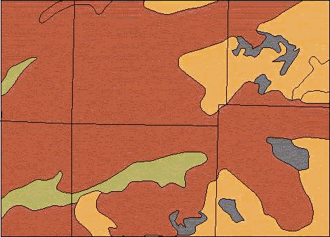
This report will first analyze soil types in order to determine the type of heavy equipment to be used. Figure 1 is a map of the soil types and their locations in the harvest planning area. We attained this map from the Soils layer of the FE423 Washougal Watershed Analysis '98.
|
|
|
Figure 1. Soil identification and location for our harvest unit in the Washougal basin. Zygore, Aschoff, Washougal, and Rock Outcrop are the four soil classifcations in our plan area.
These soils were then classified using the United Soil Classification System (USCS) and described according to its soil operability (see Table 1 in the appendix). A soil is described as "good" if no more than 30% of the soil passes through a 200 sieve which would be classified as gravels and sands. (Reference: table 13.A and 11.A in Soil Survey of Skamania County Area, Washington, October 1990) Gravels, gravelly sand, or sandy soils are highly favorable when using heavy equipment. There are no equipment restrictions and road slopes can be as high as 30-35% when these soil types are present. However, silt, silty, clay or ash soils are not favorable when using heavy equipment. The higher the fine content, the greater the hazard and restriction of equipment usage. When determining the soil operability, we also considered soil characteristics that affect the use of heavy equipment such as cohesion and saturation conductivity. Fortunately, in the planning area, favorable soil conditions exist.
Figure 3 shows the probability of failure according to soil type and steepness which represents the probability that the last fire changed the soil characteristics beyond its critical thickness. This map is useful in detecting potential areas for mass wasting. It also shows the degree of potential failure for our harvest unit. As you can see, the higher potential for failure is located on the side slopes and ridges. For some soil types, the values of soil cohesion and conductivity were zero. Unfortunately, GRID does not execute any equation where zero values are present so this results in a NODATA value. As can be seen below, the black areas are areas of NODATA.

Probability of Failure
¨
High Potential for Failure¨
Low Potential for Failure¨
No Data Available
Figure 3. Sensitive areas for the Washougal basin using the
Probability of Failure (Pfail) equation. This equation is based
on soil type and topography.
Due to the pockets of NODATA the map in Figure 3 is not completely accurate. It is reasonable to assume, however, that the NODATA areas are moderate to high since the Pfail equation is based on the friction angle of the soil angle slope. If you look up the soil values for these areas, they are mostly zero, which reflects poor stability. This prediction is based on data from the Soils layer and other related maps such as the Map of Potential Hillslope Equation.
According to the soil map, all areas are accessible by heavy equipment and our mass wasting analysis shows that our harvest unit is fairly stable. Our data was obtained through outside sources, however, so the reliability is unclear. The only way to make an accurate assessment of the sensitive areas would be to perform our own field study.
Stand Tables show dominant tree characteristics for varying site indices in a given stand which is used to determine the average size of the trees in the harvest area (see Table 3). This information was required and used for the vegetation simulators Stand Visualization System (SVS), Landscape Management System (LMS), and (FORSEE).
Table 3. 1998 Stand Table
|
SALE_NAME |
PRI_DBH |
PRI_SPEC |
PRI_HT |
PRI_TPA |
CRWN_DIA |
CRWN_RATIO |
|
Northwest/South |
12 |
DF |
115 |
153 |
17 |
0.28 |
|
North |
12 |
DF |
91 |
153 |
17 |
0.25 |
|
Tractor |
12 |
DF |
111 |
153 |
17 |
0.29 |
|
Tractor |
12 |
DF |
119 |
153 |
17 |
0.27 |
|
270079 |
8 |
DF |
122 |
286 |
12 |
0.19 |
LMS
LMS is a program designed by the University of Washington Silviculture Lab to model growth, project landscapes, aid visualization, and summarize information through stand tables. For this project, LMS was used to project dated stand information to 1998 levels. The stand table was used to extract relevant information such as average stand dbh, average height, and volume. This information was used to help in the design of our harvest system (see Table 4).
Table 4. 1998 Stand Averages
|
Year |
Stand Number |
DBH (in) |
Height (ft) |
Volume (mbf) |
|
1998 |
N |
15.41 |
96.7 |
2132 |
|
1998 |
S/NW |
17.1 |
108.1 |
5344 |
|
1998 |
Tractor |
15.34 |
96.6 |
2687 |
These stands were then projected to 2028 levels (see Table 5). With these values, changes could be made in the 1998 harvest design system to meet the needs of a system harvest larger trees.
Table 5. 2028 Stand Averages
|
Year |
Stand Number |
DBH (in) |
Height (ft) |
Volume (mbf) |
|
2028 |
N |
22.08 |
128.8 |
5187 |
|
2028 |
S/NW |
23.54 |
145.6 |
2541 |
|
2028 |
Tractor |
23.07 |
134.3 |
1648 |
This information is crucial to the final setting design as it provides both present and future wood values in our harvest area. Given the average tree size, design constraints can now be specified for the yarding system. Also, since these projections were done in 10 year increments, an economically efficient plan can now be developed considering issues such as whether tractor logging should be done first or last. Finally, this program made it possible to examine the changes in HCP restrictions as the stand aged. Overall, the LMS program eliminated the guesswork involved in future planning of harvest areas.
SVS
Although the SVS program has little impact on the final harvest plan, it can be used to visualize individual stands at present and future dates. This reference helps determine the crown closure of the stands and their suitability for wildlife areas.
An SVS visualization of our typical harvest unit in 1998
An SVS visualization of the retention stands at harvest in 2028
Although the stand images created did not strongly impact the final harvest plan, they provided a better understanding of the current and future stand structure. This capability will help in any kind of silvicultural planning, whether it be thinning or a habitat cut, as it can clearly displays the results of management activities. SVS is an important tool in any forest activity that will visually affect the aesthetics or structure of the current stand.
FORSEE
FORSEE is a computer program that uses a stand table to estimate total volume and weight and then produces a graphic to visualize a given vegetation system. In addition to using a stand table, FORSEE considers other stand characteristics such as scaling rules, additional fiber weights and board foot weight.
Once the program is run, a series of reports are produced: stand summary, log tally, and piece tally. The stand summary displays weight and volumes by species and size class totals for merchantable, unmerchantable, and unutilized materials categories (see Table 6). This provides a general summary of the timber which will be useful in determining the harvest system, number of truck loads and production. This table is useful in determining the type of operation needed and the result of the specifications used, such as HCP specifications. The results of FORSEE will be later be used in another program, Helipace, which will be discussed later in this report.
Table 6. This is the stand summary totals for the entire harvest area according to the stand table data (see Table 3) and timber specifications. (Note: These are green weight estimates)
|
Merchantable Material: |
||||||||||
|
|
Stems/acre |
Volume (ft3) |
Volume Scribner (bd ft) |
Bole Weight (lbs) |
Bark Weight (lbs) |
Total Weight (lbs) |
||||
|
Totals: |
427.6 |
11053.5 |
42792.0 |
367533.0 |
0 |
367533.0 |
||||
|
Unmerchantable Material: |
||||||||||
|
|
Stems/acre |
Volume (ft3) |
Bole Weight (lbs) |
Bark Weight (lbs) |
Total Weight (lbs) |
|||||
|
Totals: |
427.6 |
395.5 |
13149.0 |
0 |
13149.0 |
|||||
|
Unutilized Material: |
||||||||||
|
|
Stems/acre |
Volume (ft3) |
Bole Weight (lbs) |
Bark Weight (lbs) |
Total Weight (lbs) |
|||||
|
Totals: |
427.6 |
331.4 |
11227.0 |
0 |
11227.0 |
|||||
Table 7 is a Log and Piece tally which displays merchantable and unmerchantable log counts according to species. This table describes the amount of pieces and logs that can be attained in the harvest unit. For this analysis, the tables are the same because the number of logs is the same as the pieces from the logs. These tables will be useful in determining the yarding system, truck loads, production and specifications used to abide by HCP or FPA rules.
Table 7. Log Tally and Piece Tally for the entire harvest area according to the given stand table and specifications.
|
Piece Tally and Log Tally by Species (includes logs ripped to meet weight constraints as separate pieces) |
||||
|
|
Species |
Merchantable Pieces |
Unmerchantable Pieces |
Total Pieces |
|
Totals: |
202 |
962.1 |
855.2 |
1817.3 |
In addition to tables and summaries, FORSEE produces a stand and treatment graphic. Figure 6 is a stand graphic which displays a plan view of the entire stand and each crown. Within this graph, you may also make any adjustments to the picture of your stand.
The treatment graphic in Figure 7 displays trees that have been felled and is based on the image in Figure 6. The cut tree crowns are displayed in red and the tree boles are shown in black. This graphic can also be adjusted. This map is a helpful tool in visualizing the result of a harvest.
The results provided by FORSEE give a good indication of the type of stand that is present. Once the data is entered into the program, it can be manipulated to test different specifications such as payload and form class. This is useful in determining the type of harvest system and how HCP or FPA rules affect your stand. These results can now be used as input into the Helipace stand analysis which is discussed later in this report.
Contributed by Dolly Tyndall, Paul Reed, Luke Rogers and Jim English
Methodology
Choice of harvest systems for Washougal Drainage watershed is based on a number of broad design parameters. These categories are:
The different criteria to consider with regard to each of these design elements is taken in part from Berg and Schiess, 1996 in a paper submitted to the Clayoquot Sound Symposium.
Physical Design Elements
The geomorphic template of the landscape dictates many design decisions. Fluvial network of the streams is the backbone of basin hydrology and is influenced by activity on the adjacent slopes. These are the areas where the stability zones are identified, based on slope steepness, parent geology and soils. In the Washougal Basin, the presence of unstable soil conditions requires careful planning when designing the settings. Weak or potentially unstable areas were considered as partial cutting areas only, with full suspension. Rain-on-snow events are of concern at higher elevation settings and are addressed at the landscape level by limiting the rate of harvest. Retention of trees or patches of trees with heavy root systems (e.g. dominant and co-dominant canopy classes) was also considered, since it can soften the cumulative effects of the peak run-off within the managed forest matrix.
Technical Design Elements
To reduce logging related slope failures, better deflection line analysis is necessary when designing cable logging. Elements such as skyline systems (live, standing or running), landing locations, tower height, cable diameter, tail-hold anchors & heights, payload, topography and silvicultural system, were used to determine the suspension capabilities in a particular deflection zone. With current technology, ground based equipment is typically excluded from slopes in excess of 30 to 40 percent slope while silvicultural systems, such as clear-cut or selection-cut, may further restrict use of certain systems.
In areas of silvicultural retention log retention, log control during the yarding cycle is of paramount importance with regards to residual tree damage, ground disturbance, and yarding productivity. The design of the unit is driven by the retention plan. Full suspension zones allow for dispersed and variable density retention due to the flexibility in log control while partial suspension zones imply preferred patch cutting or wedge retention. The log control is affected by:
Corridors not in the fall line of the slope (or perpendicular to the contours) result in cross-slope or sidehill yarding. Under such situations, log control becomes difficult for partially suspended logs during inhaul. The trailing end of the log, dragging along the ground, tends to swing towards the fall line, away and downhill from the skyline corridor. This action results in added ground disturbance, and in the case of partial cut regimes, in wider corridors with higher damage to the residual stand. Differences of as little as three degrees between the corridor orientation have been known to cause the trailing end of the log to swing downhill, resulting in increased ground disturbance and residual tree damage. In such situations, full suspension may be required in order to keep corridor width, ground disturbance and residual tree damage within acceptable levels.
Where corridor locations cannot be marked prior to the beginning of falling activities, or where corridor locations may change after falling activities, falling timber parallel to contours should be the preferred option. Log length, skyline height in the corridor, and the ability to reposition carriage during lateral inhaul become important parameters in such situations.
Logger Preference
When planning the designing settings, an important factor often overlooked is the preference of the logger. Loggers know how their operating costs affect production and consequently, time and money. In order to maximize production, the amount of sidehill yarding and the length of yarding distances should be addressed. Knowing that there is a distinct preference for uphill yarding in cable systems, landing locations should be placed to maximize the amount of uphill yarding. Loggers favor yarding distances of less than 1000 feet.
Using PLANS
By using the PLANS program, the technical feasibility of a setting was assessed. Using three design-yarding systems (live, standing and running), the landing locations were chosen off the screen-based DTM. Radial settings were analyzed and placed into a progressive plan.
The main goal of the landing locations was to find areas of maximum coverage with appropriate consideration to stream buffers and mass wasting. Once these two constraints were evaluated, the next step was to weigh any biological, physical or technical restraints. Finally, when the landing locations were selected, Logger's Preference was considered, resulting in settings with optimal AYD's under 1000 ft, mostly with uphill yarding.
After careful consideration, we decided against logging across the fish bearing streams for two reasons. The first reason was due to environmental considerations of yarding over the riparian area. Secondly, the economic viability of harvest management in that area was poor due to low-volume timber and increased yarding distances. For the streams classified as Type 3, we used a 100-foot buffer zone, as per the Board Manual: Standard Methodology for Conducting Watershed Analysis: Under Chapter 222-22 WAC, Version 4.0, November 1997.
Anchor Installation
The Nakamura holding capacity equation:
F = 0.285D1.65..............................(Equation 1)
Where
F is the maximum holding force of the stump (kips)
D is the diameter (in.)
This equation is used to find the minimum stump diameter for a given line size and was taken from Skyline Anchors and Multiple Anchors: Luke A. F. Merry, College of Forest Resources, University of Washington, March 1985. The cable breaking strength in Table 8, was taken from the U.S. Forest Service 1978 Logging Systems Guide, p.43.29a--1, (for 6 x 19, 6 x 21, or 6 x 25 Independent Wire Rope Core (IWRC), Extra Improved Plow Steel (EIPS) wire rope). This shows the minimum stump diameters for different line sizes calculated using Equation 1.
Table 8. Breaking strengths of cable.
|
Line Size (in.) |
Breaking Strength (kips) |
Stump Diameter (in.) |
|
3/4 |
58.8 |
25.3 |
|
7/8 |
79.6 |
30.4 |
|
1 |
103.4 |
35.6 |
|
1 1/8 |
130.0 |
40.9 |
Table 1. Minimum Stump Diameters for a Given Line Size
From Table 1, it is clear that multiple stumps will need to be rigged as tailholds in order to harvest our settings. Some possible rigging situations are discussed in the appendix (under costs).
Payload Analysis
To estimate the mean payload, the number of chokers on a line must be selected. In our analysis, we selected three chokers. The total weight of the number of selected logs, three in this instance, estimates a single payload weight. When analyzing PLANS, we used a payload of 10,000lbs, which will still be applicable 30 years into the future.
Using an USGS 1:4800 contour coverage we were able to analyze the harvest area for yarding feasibility. The DTM and PLANS enabled us to view the potentially harvestable areas and analyze each profile individually. Initially, there was some discussion about harvesting timber on the northwest side of the type three stream. However, after better stand information became available, this idea was scrapped. The timber turned out to be too small for the yarding distances involved, and it appears that there is better access form the road on the next ridge. For this reason, the Type 3 stream defines the unit boundary to the northwest and to the southeast. The ridge top defines the remaining boundaries to our units.
Due to the large area of consideration, four units were designed. The three units to the northwest should be the first to be harvested. Each of these units has a rather large retention area that will provide habitat as required by regulations for dispersal areas. These retention areas separate the units by more than 200 feet, which allows harvest of all three units simultaneously. The ground-based unit on top of the ridge is to be harvested in the year 2008 to comply with 1997 HCP adjacency regulations.
To fully maximize the production from the harvest area, an access road along the northwest unit boundary should be constructed. This will allow greater flexibility when harvesting the current retention areas in the year 2028. In addition to clearcutting the current retention areas in 2008, an option would be thinning of the 30-year-old timber in the currently planned clearcuts. Constructing a long spur road along the north side of the ridge will allow more flexibility in thinning procedures, thereby enabling thinning from the road instead of a central landing. Given the aspect and slope of the current planning units, thinning in the year 2028 will provide better returns for future harvests.
Table 9. Acreage and Harvest Schedule for the first ten years
|
Unit |
Harvest Year |
CC Acreage |
Retention Acreage |
Total Acreage |
% Retained |
|
North |
1998 |
24.4 |
15.8 |
40.2 |
39.3 |
|
North West |
1998 |
34.5 |
25.8 |
60.3 |
42.8 |
|
South |
1998 |
53.1 |
12.9 |
66.0 |
19.5 |
|
Tractor |
2008 |
73.2 |
20.1 |
93.3 |
21.5 |
For the year 1998 through 2000, the total acreage for the entire unit that will either be harvested or retained is shown in Table 9. From the output analysis derived using PLANS, we were able to decide leave and clear-cut areas, based on the soil conditions and topography.
Table 10. Harvest Volume (Mbf) for each unit during the first ten years
|
Unit |
Harvest Year |
CC Mbf |
Retention Mbf |
2028 Retained Mbf |
|
North |
1998 |
907 |
587 |
1464 |
|
North West |
1998 |
1283 |
959 |
2391 |
|
South |
1998 |
1974 |
480 |
1196 |
|
Tractor |
2008 |
2955 |
811 |
1480 |
The harvest volume and the retention volume (Mbf) for the first ten years are shown in Table 10. After thirty years, the predicted harvest volume from the retained trees is displayed in the right hand column of the table. The retained Mbf has more than doubled in most of the units. Therefore, it will be more profitable to return and harvest the areas that were retained in 1998.
Contributed by Dolly Tyndall, Jim English, Paul Reed and Jason Bradbury
Our objective was to determine the costs of various logging systems that could be used in our harvest plan in the Washougal Watershed. This information will be used in conjunction with results from PLANS to determine a feasible harvest plan that maximizes production and profit, yet have a limited impact on the environment.
To make a comparison, we looked at two Thunderbird yarders, TSY6255 and TTY6170. We chose the TTY6170 yarder with the taller 70-foot tower, as this will provide the necessary deflection for our cable settings. Even though the cost per MBF is similar for both yarders, the TTY6170 is capable of higher production per day. This will reduce the numbers of days required to log this unit, thereby increasing profit.
The four units were individually analyzed for present and future harvest and cost estimation for each unit was determined using Skyap 97.
Table 11. Harvest cost comparison and production of the four units in our harvest plan.
|
Unit Location |
Year |
Acreage |
Volume |
Cost ($) |
Production |
|
South |
1998 |
53.1 |
1974.0 MBF |
125.95 |
22.19 MBF/day |
|
South |
2028 |
53.1 |
4511.6 MBF |
56.14 |
73.65 MBF/day |
|
Northwest |
1998 |
34.5 |
1283.0 MBF |
105.17 |
30.22 MBF/day |
|
Northwest |
2028 |
34.5 |
19.32 MBF |
71.01 |
48.51 MBF/day |
|
North |
1998 |
24.4 |
907.0 MBF |
106.83 |
30.06 MBF/day |
|
North |
2028 |
24.4 |
1366.4 MBF |
72.36 |
48.33 MBF/day |
|
Tractor |
1998 |
73.2 |
2306.0 MBF |
58.23 |
40.00 MBF/day |
|
Tractor |
2008 |
73.2 |
2955.0 MBF |
48.28 |
50.00 MBF/day |
Additional data or information can be found in the appendix under Cost.
Considering the terrain and environmental constraints of this region, we recommend logging the North, Northwest and South units in 1998 and the Tractor unit in 2008. The cable units are laid out with relatively short AYD's without logging across the streams. This will minimize environmental impact and provide overall economic feasibility. To accomplish this, the Thunderbird TTY6170 or a similar yarder should be used. The recommendation that the Tractor unit be logged in 2008 is due to adjacency issues. To log the Tractor unit in the year 2008, we recommend a crawler and rubber-tire skidder combination, such as a CAT D6H and CAT 518.
Webpage created and maintained by Kai M. Brown
Last updated March 19, 1998