Paul Carpenter
Jesse Saunders
Cathy Lander
Summary Table
Web Site Findings Related to Public Land Surveying Practices in the United States
Web Site
|
Description
|
|
Definitions and pictures of sections and townships |
|
|
Definitions of townships, sections, etc |
|
|
Map of primary meridians and base lines (US) |
|
|
http://lm0005.blm.gov/nils/bus.req/Reqs-pdf-docs/sec3-land-rec.pdf |
Detailed description
of land records environment (includes legal descriptions, history, and
numerous data mediums). * |
|
http://lm0005.blm.gov/nils/bus-req/NILS-tour3-00/nils3-00.pdf |
Incorporation of electronic transfer of surveys* |
USGS aerial photography* |
|
|
Description of how numbering of townships, sections, and corners are found (includes pictures). |
*detailed description below
Descriptions of Web Sites
http://www.ukans.edu/carrie/kancoll/articles/survey/sat.htm
This site covers basic descriptions and illustrations in regard to Sections and Townships, Baseline and Meridian, and Townships and Ranges. It leaves the viewer with a general knowledge of the Land Survey System. Layout of this site is illustrated in the example below:
.
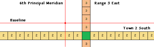
The example below illustrates the location of Town 2 South, Range 3 East of the 6th Principal Meridian, which
correlates approximately with Washington
Township of Washington
County, KS.
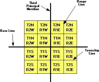
http://www.outfitters.com/genealogy/land/twprange.html
This site contains a sample exercise in finding a particular township, section, and section quadrants.
A further overview of the Land Survey System. This is a great site for a beginning surveyor.
http://www.ca.blm.gov/cadastral/meridian.html
As seen below, this site illustrates principal meridians and baselines found in the U.S. The intersection of these 2 coordinates begins the system of township layouts (see B.)
A.
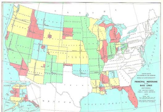
B. The intersection of these 2 coordinates begins the system of township layouts (example from http://www.outfitters.com/genealogy/land/twprangemap.html).
. 
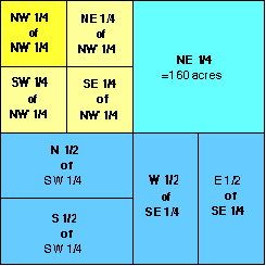
http://www.outfitters.com/genealogy/land/twprangemap.html
This site is a general site for finding information on townships, sections, and subdivisions thereof. The illustration below shows subdivisions of a section.
Detailed Descriptions of Unique Web Sites
http://terraserver.microsoft.com/default.asp
This site gives one a map of the U.S. To find the aerial photograph of a region, simply click on it. The area chosen can be incrementally reduced to maps of greater detail display. By zooming in, one gets closer views via sections and subdivisions thereof. This type of information could be useful in the forestry industry in terms of locating forested versus clearcut stands, road location, and various other geographical features. In addition to aerial photos, once a site is selected, it can also be viewed as a topographical map or a relief map.

The photo above was pasted from the above web site. This area is the southern section of the University of Washington campus. Husky stadium is seen in the lower right hand side.
http://lm0005iblm.gov/nils/bus-req/NILS-tour3-00/nils3-00.pdf
We found this great visual site by searching for public land survey from within BLM’s survey page.
National
Integrated
Land
System
This company works with BLM and the Forest Service to provide better electronic tools for land management. You can view their vision statement on page 5 of the document.
Following is a list of our favorite pages of this presentation:
PAGE Description
6 Layered view of where datum sets correspond with each other.
7 Diagram of land survey system data linked with geographic data.
11-13 How information is kept organized with technology.
23 Photos of actual land records.
24-46 Model layouts and flow charts of NILS business project process.
60 Great diagram of how legal descriptions of land fit into the picture.
47-66 Definitions of Key Terms including measurement formulas.
http://lm0005.blm.gov/nils/bus.reg/Regs-pdf-docs/sec3-land-rec.pdf
This BLM site contains a another link to a report titled Land Records Environment created by the National Integrated Land System (NILS). Page 1 discusses Cadastral and land records concepts. Also mentioned are control surveys which are important for establishing a special reference framework for all parcels mapping.
Page 2 contains a map of longitudinal changes from various geodetic datums.
Page 4 contains information on the State Plane Coordinate System. This is a map projection system that minimizes angular distortions if only a small portion of the earth is flattened out.
Pages 7 mentions warranty and quit claim deeds. These are important in transfer of ownership. A document important to local and county governments is a survey plat which describes the observations and measurements made by a licensed land survey (illustration shown on site).
Page 8 deal with describing what one owns and the extent of what they own. What property rights does the land owner have? The separable rights are important to NILS because to support federal land management and to determine the federal land ownership status all of the separable rights must be tracked through time.
Page 9 gives a brief history of the Public Land Survey System and the need for it. It also shows another good example of a Township grid.
Lastly, pictures of original master title plats and indexes are shown. This is a neat look back at history showing the beginnings of our current public land survey system.
“NILS envisions the ability to make parcel-based land information available for all managers, specialists and the public in an organized automated environment.”