Jason
Martin, Andrea Duvall, Chris Carusona, Luke Holden
Web
Search
FE
345
1) http://www.outfitters.com/genealogy/land/twprangemap.html
This web site gives you a nice colored portrayal of
the township and range system. It
describes the numbering system, as well as the quartering of the section. Another nice feature is that it is also a
jump off point to other information, such as the Legal Land Descriptions in the
USA.
This web site gives you a large number of surveying
or mapping links. About two-thirds the
way down there are nice descriptions and pictures of the U.S. Rectangular
Survey, Township Sections, Subdivided Section, and A Township and Range
Property Description. There are other
references to Metes and Bounds, State Plane Coordinates, Irish National Grid,
and other interesting links.
3) http://www.waukesha.tec.wi.us/busocc/reallaw/out4b.htm
This gives you a good out law of the Real Estate
Laws, describing Metes-and-Bounds, Rectangular survey system, as well as
preparation of a Survey, Measuring Elevations, and Land Units and Measurements.
4) http://www.lmic.state.mn.us/gc/dir/keys/usplss.htm
This is a web page that gives you 32 different links
that deal with Public Land Survey System.
5) http://www.outfitters.com/genealogy/land/twprange.html
This is a web page that gives great definitions of
Legal Land Description terminology. A legal land descriptions in
federal township and range system In the Southern United States in the State-Land states, land is
surveyed in the indiscriminate metes and bounds system, not the federal
township-range system. The metes and bounds survey system uses natural land
features, such as trees and streams, as well as neighboring land owners, along
with distances to describe plots of land.
6) http://www.uta.edu/paleomap/homepage/Geoscience/PhysGeolLab/township.htm
Explains
the township and range system. This
site defines the Township and Range System with figures to support them.
Locating yourself, or defining features can be easily attained with the
Township and Range System. The basic
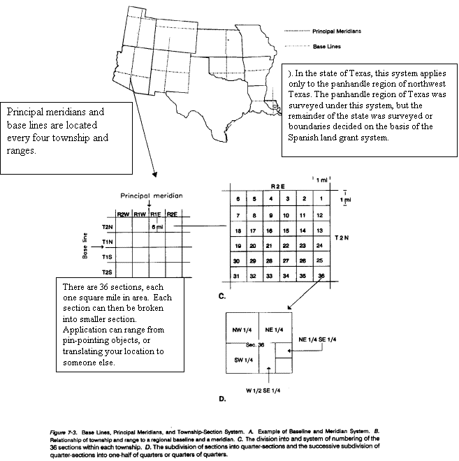
make-up of the system is the base lines and principle meridians (Figure
7.3A). Townships are found by locating
the intersection of the corresponding Township and range.
7) http://www.geneaview.addr.com/survey.html
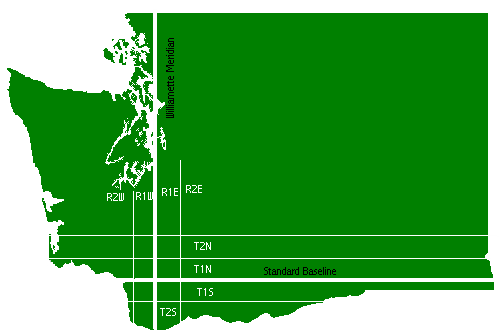
A
guide for understanding the Township and Range Survey system. Includes a diagram of Washington State and
definitions.
I.
As
the settlement of eastern North America by Europeans, land claims became very
important. By 1785 the Land Ordinance
was passed by congress to promote settlement and raise capital for the
nation.
1. The law
required that from a point where the Ohio River crossed the Pennsylvania
border, a north-south line became the principal meridian and the east-west line
became the base line to survey westward
II. Meridian and baselines are defined by North-South lines that start at points for rows of townships east to west. At every six miles a line separates the townships, east and west of the meridian. This dividing line is known as range, and is designated by the North-South township (see WA state figure below) and range number.
II.
Townships
are measured about 6 miles on each side and contain approximately 23,040
acres. The township is defined by its
relationship to a base line and a principal meridian.
III.
The
section number identifies a 1 square mile within a township. Townships usually contain 36 sections. The standard sections contain 640 acres,
which is identified by a section number.
The section numbering begins with the northeastern most section of the
township, and continues to the west to section six. The numbering system alternates every six sections, going from
east to west, then west to east, then east to west once again (see township
diagram).The section number is further broken down into quarters, referred to
as aliquots. The halves of a section
are represented as N, S, E, and W. Quarters of a Section (or subdivision
thereof) are represented as NW, SW, NE, and SE