Project No. 1
Map Locations
of Roads
Transportation
FE 345
Spring Quarter
|
|
Project No. 1 Map Locations of Roads |
Transportation FE 345 Spring Quarter |
Phase I. Route Selection and Field Reconnaissance Preparation
You will be given a topographic map of Pack Forest. Two existing roads are labeled 'Road #l' and 'Road #2'. A landing site is also marked. Our job this Quarter is to design, locate and stake a road connecting the landing to Road #1 or #2.
First create a slope class map using a set of divider. Draw the slope classes on a mylar overlay.
The slope classes to use are
0 - 30 percent
30 - 50
>50
The information is useful to evaluate generally suitable road location areas.
2. Road Location (pegging)
The next step is to "peg" a paper road location on the map, first from the landing to Road #1, and then from the landing to Road #2. Road standards to use are:
- maximum grade = 10% adverse, 15% favorable
- minimum curve radius = 60'
- switchback on < 35% sideslopes only
- 12' running surface
- total length of road, which runs parallel to a creek within 150 ft,
cannot exceed 500 ft.
- stay within the Pack boundary
Check references
Various references on the class web page
Divide the road into the following sideslope classes and determine road length (in stations) for each class:
sideslopes
0 - 30 percent
30 - 50
>50 percent
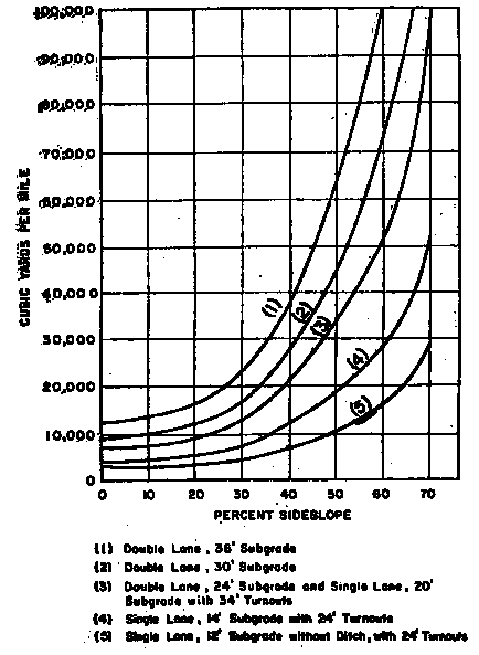
For each slope class calculate the required excavation volume based on a standard cross section with the following dimensions for each road:
The following road dimensions are to be used:
|
Traveled width |
12 ft |
|
Ballast depth |
12 inches |
|
shoulder slope |
2:1 |
|
Ditch width and depth |
3 ft, 1ft |
|
cut slope ratio |
1:1 |
|
fill slope ratio |
1.5:1 |
assume that 2/3 of road bed are in hill slope and 1/3 on fill portion
Use the following average side slopes
|
for roads on slopes in the range of: |
use this average slope value |
|
0 -30 % |
20 % |
|
30 - 50 |
40 |
|
> 50 |
60 |
Estimate road construction costs for each alternative using the USFS excavation rate. Assume common earth for excavation and costing purposes.
Road construction costs consist of
-Clearing & grubbing
clearing is the process of removing (felling) timber from the right of way
grubbing is the process of removing stumps/rootwads from the construction area
typically a common cost value is used for clearing & grubbing of $ 600.-/acre
-Excavation; use table values below
U.S.F.S. unit rate for excavation.*
|
Type of Material |
Base Unit DOLLARS/CYD |
|
Common |
$0 90 |
|
Rippable |
$1.80 |
|
Solid |
$3.60 |
Slope Adjustment Factor adjust base rate with factor below, based on material
0-30% : 1.0
30-50% : 1.2
Over 50% : 1.4
-Rock (Road ballast); @ $ 10.-/cubic yard in-place
-Cross drain culverts @ 100.-/station
stream culverts separate, if any
Report the costs as total $ values and also in $/station.
Provide the relative ratios (percent) of each cost component in the total (e.g. clearing/grubbing, ballast, excavation, drainage/culverts)
6. Choose one of your two locations as the 'best' road to build. Justify your choice (e.g. based on total cost, location, stream proximity, etc)
7. Keep both road locations marked on your map, but for the chosen 'best' location clearly mark grades to run and distances to each grade break and bearings on the map. A copy of this map will be taken into the field and will be the basis for your trial gradeline.
8. Turn in a report containing your map and all of the information discussed above.