A Thinning and Access Strategy for Accelerated Stand Habitat Creation
Burnt Mountain
Prepared by:
University of Washington
Senior Forest Engineering
Class of 2000
Under the direction of:
Dr. Peter Schiess
Professor of Forest Engineering
Prepared for:
Tom Robinson
Region Manager
Olympic Region
Department of Natural Resources
Forks, Washington
Executive Summary
During spring quarter 2000, the University of Washington Forest Engineering program developed A Thinning and Access Strategy for Accelerated Stand Habitat Creation in the Burnt Mountain Block of the Olympic Experimental State Forest. This project is a collaborative effort between the DNR and UW designed to provide real-world experience to the forest engineering class, while also supporting DNR management goals.
The project develops a harvest and transportation plan that provides habitat and economic outcomes. It also identifies alternative harvest strategies to aid in road density management, and also highlights new technologies and ideas for providing more intuitive representations of potential management outcomes in a visual format.
Another goal is to identify options for research and monitoring as specified in the HCP for the Olympic Experimental State Forest. In support of this need, the plan identifies harvest systems by setting, providing information needed to determine the type of silvicultural systems that can be implemented on a setting basis.
To provide opportunities for habitat creation during harvest operations, three silvicultural options are assessed: single-density thin, variable-density thin, and no-harvest. Outcomes of each option are assessed using growth models projected to the year 2040.
Economics of each option are also examined. This includes costs associated with harvest as well as road construction needed to reach these units.
From economic and habitat creation inputs, four scenarios are developed and details of habitat creation and economics are provided for each.
Based on management needs and desired outcomes, Scenario Three, a modified variable density thin, is recommended for the 1,679 harvestable acres in the planning area. Variable density thinning will create the desired habitat over 99% of the acreage by the year 2020. Of the operations analyzed the combined log length and whole tree yarding (modified variable density thin) shows the best return ($121/Mbf) over most of the planning area. The combined variable density thin with an 80 acre regeneration harvest would be the next best option. It has a net return of $77/Mbf to the trust and is able to access 1244 acres because regeneration harvest pays for the road construction. The last two options, variable density thinning and helicopter thinning would be the last choice due to the small amount of returned profit to the trust (helicopter $29/Mbf, and variable density thin $25/Mbf). But one advantage of the helicopter option is only 52 stations of road would have to be constructed.
Table 1 Stump-to-truck cost, revenues and road construction activities for three basic thinning regimes which also includes helicopter. The modified variable density thinning allows for best returns due to increased payloads made possible by tree-length yarding in settings where residual trees per acre drop below 100.
|
Scenario I |
Scenario II |
Scenario III |
Scenario IV |
|
|
Variable Density Thinning |
Variable Density w/ 80 Acre Re-Gen Harvest |
Modified Variable Density |
Thinning w/ Helicopter |
|
|
Area Harvested (Acres) |
397 |
1244 |
1,679 |
2,557 |
|
Vol. Harvested (mbf) |
2086 |
10,861 |
12,505 |
17,446 |
|
Haul Cost ($/mbf) |
35 |
35 |
35 |
35 |
|
Harvest Cost ($) Harvest Cost ($/mbf) |
590,720 283 |
2,494,124 230 |
1,877,191 150 |
6,280,560 360 |
|
Road Cost ($) Road Cost ($/mbf) |
182,039 87 |
954,399 88 |
1,555,390 124 |
102,947 6 |
|
Road Length (sta) |
91 |
477 |
777 |
52 |
|
Return To Trust($) Return To Trust ($/mbf) |
51,593 25 |
836,297 77 |
1,513,105 121 |
505,934 29 |
To support management goals of reducing road densities across the landscape, the plan also includes assessments of alternative harvest systems. The two systems examined are long-span cable yarding and helicopter yarding.
Long-span yarding was determined to be appropriate in areas where ridge-to-ridge corridors can be placed. Analysis of the planning area identified approximately 264 acres in the north section where use of long-span systems will enable the elimination of 41 stations of road.
The south section of the planning area did not provide opportunities for road density reduction using long-span systems. The reason for this is the dissected topography of the area. Dense networks of north-south ridges prevented development of long-span cable corridors. As a result, a denser road network is needed to support traditional length cable spans.
Thinning by helicopter is also assessed as a strategy for reducing road densities. Approximately 2,557 acres in the planning area are identified as appropriate for helicopter thinning, providing 17,446 mbf. This option produces the least return to the trust ($29/mbf) due to the high cost of operations, but provides the greatest road density reduction opportunities, requiring approximately 50 stations of road construction. Average stump-to-truck costs are estimated at $360.-/mbf, road construction and haul costs at $ 6.-/mbf and $ 35.-/mbf, respectively.
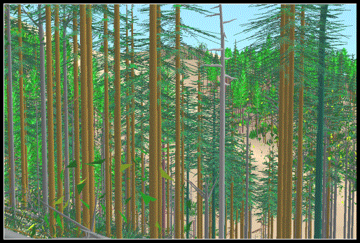
A continuing focus of the UW’s involvement in these projects is to highlight and showcase new technologies that give land managers increased options for communicating land management outcomes. The most recent addition to this toolbox is the visualization program EnVISION, being developed at the UW by the Forest Systems Engineering Research Cooperative (FORSYS). The EnVISION program provides landscape images for use in modeling management impacts on the landscape. Below is an example of a variable density thin modeled on the Burnt Mountain Planning Area.
The EnVISION program is still in development at this time. The final version will use tree images derived from actual photographs to provide a “photo realistic” image of the landscape. The UW expects this tool to be useful for communicating management prescriptions in terms that a broader audience can grasp, even those without a natural resource background.
Other technology developed during this project consists of conversion programs to import FRIS data to FVS, and also web-based project development.
The UW team developed a conversion program to take FRIS data and put it into a format that can be used in FVS. This allowed us to grow stands forward in time using data from each individual tree vs. a “stand average” tree. This provides more realistic representations of future conditions, something not possible with current approaches.
Web-based project development was used to allow interested parties access to project results in an on-going fashion. Using map management software (ER Mapper), we were able to post planning and results maps on the web in a format that preserves detail and resolution while allowing for extremely fast re-draw speeds.
A secondary goal of the planning project is to identify settings appropriate for research activities. The criteria used to identify these areas are:
· Average stand ages between 40 and 60 years.
· Accessible by either ground systems or cable systems.
· Returns a net profit to the trust.
By identifying the type of system that can be used on each setting, realistic silvicultural prescriptions can be identified and placed within the planning area. This supports design of a statistically valid research program by allowing for random placements of research settings.
Silviculture data has been developed for all of these stands using differing treatments. Also provided is information about habitat creation resulting from each option (see sliviculture section of report).
Opportunities are identified for long-span cable yarding (mostly in the NE area), and single and variable density prescriptions to be applied. This information can be found in the section on yarding costs and also the habitat and economics section.
The above map, identifies areas where thinning operations can be carried out economically. The types of yarding system appropriate for each setting are identified.
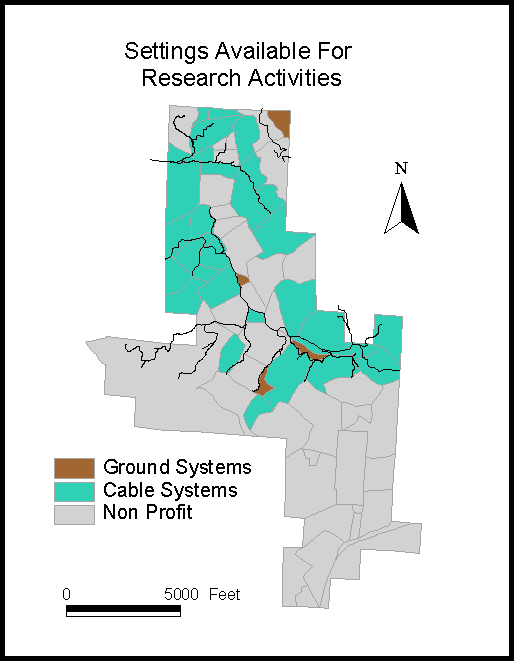
Figure 1. Potential Research Settings Having Positive Return to the Trust and the required road system that is required for the cable thinning operations