9 Preliminary Road Design Process
The first step in the laying out of the roads was to peg in their locations. This was done by using ArcView Pegger, an extension that was developed by Luke Rogers.
Preliminary landing locations were developed by PLANS. These landings were then imported into the GIS layers. Using this information along with 5' contours (generated from the LIDAR DEM), slope classes, slope stability, stream locations and buffer zones, control points were then identified. Several roads were then pegged in connecting the landings to the existing road network.
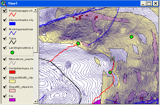
Figure 18: A screen capture from pegger.
We considered using 1' contours since our LIDAR data is accurate to about 6'. The file sizes for these maps were more than a gigabyte. Since we did not have computers that could handle such large files we used five foot contours. In addition, use of the 1' contours would have required interpolating the elevation from the LIDAR data. Once the roads were pegged, they were saved as shape files.
After the roads were laid out, the next step was to perform an analysis on these roads. This examination was very specific and broke each road up into smaller sections. The assessment included such factors as length, side slope, and line slope. All of the issues were evaluated within ArcView using the line slope calculator and other GIS functions.
Then the roads were merged into one shape file for each sheet map. The pegger program can then be used to calculate the grade of all the road sections. When roads were pegged manually (instead of using pegger), the grade can be set equal to the line slope determined from the previous analysis. Merging all of the individual shape files for each sheet box resulted in one shape file containing all of the pegged roads in the project area.
The costing analysis was preformed by using the North Tahoma Road Costing Spreadsheet. Since this was a preliminary cost analysis, average values were chosen for many of the variables. The analyzed data was then compiled in each roads attribute table.
There were several design guidelines we had to keep in mind when pegging in our roads. These guidelines are outlined below:
9.2.1 Side Slope Considerations
Full Bench Road Design:
Under the HCP with which we are working with it states that all roads constructed on side slopes in excess of 45% must be designed with a full bench road prism. On roads with side slopes between 45%-55% a full bench road prism is required, but the excess material can be side cast and compacted. Any road that is constructed on side slopes over 55% must have a full bench road prism and any excess material must be end hauled to a suitable disposal site.
Balanced Cut/Fill Road Design:
On all roads constructed on side slopes of less than 40% a balanced cut/fill road prism may be used.
9.2.2 Road Grade Considerations
Favorable road grades are defined as the downhill travel of a loaded log truck. Truck performance, safety, and DNR road standards limit the favorable grade to 18%. Adverse road grades are defined as the uphill travel of a loaded log truck. Truck performance and DNR road standards limit the adverse road grade to 12%.
9.2.3 Alignment Considerations
The minimum curve radius used in the preliminary design of horizontal curves was 60 feet. The minimum curve radius was increased to 80 feet for switchback curves.
9.2.4 Stream Crossings Considerations
One of the main priorities when designing our roads was to minimize stream crossings. The HCP states that all crossing structures must be capable of passing the 100 year flood. Type 1, 2, and 3 streams were therefore only crossed when absolutely necessary. All Type 4, 5 and 9 stream crossing structures were assumed to be corrugated metal pipes.