12 Alternative Harvest Systems Analysis
The alternative harvest systems analysis explores the use of helicopter yarding and long span yarding as alternatives to conventional harvest systems. These alternatives are explored in areas where conventional systems would require the construction of new roads, or the use of existing roads in poor locations. There are several reasons for performing an analysis of alternative harvest systems. Most notably, the alternative analysis provides an opportunity to reduce the impact from roads and perhaps reduce the combined cost of harvesting and road construction. Additionally, as these undesirable roads are eliminated, the liabilities from these roads are also eliminated.
Unfortunately, performing an alternative analysis is not as straightforward as it may seem. The analysis is limited by the technology currently available for harvest planning. Current software limits the number of options that can be explored, so it becomes inefficient to provide a complete analysis of multiple options.
Another difficulty in alternative analysis revolves around the long span alternative. The setting boundaries for long span harvest systems are, by nature, different from conventional settings. This becomes a problem when comparisons are made between the different options. Direct comparisons cannot be made, so concrete results are difficult to achieve. This problem is compounded when an alternative analysis is attempted on an individual timber sale rather than on a landscape wide basis. However, this problem does not exist in the analysis of helicopter yarding as an alternative because helicopter settings and conventional settings can be the same.
12.2.1 Methods Employed
Helicopter yarding is considered as a potentially viable alternative to conventional harvesting in areas where access is limited, road construction is restricted, or where terrain makes road construction difficult or impossible.
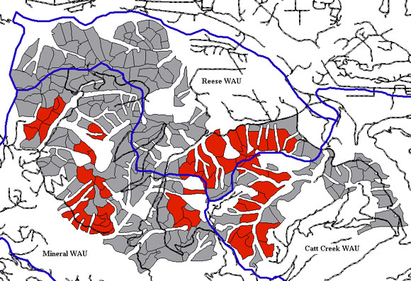
Figure 43: Settings analyzed for possible helicopter yarding.
Fig 43 shows all settings considered for alternate helicopter harvest (in red). These settings were chosen based on the conditions listed above. Areas where clear cutting is allowed, such as in the Reese WAU, will most likely be harvested in conventional fashion.
Areas in Reese WAU that were considered for helicopter yarding were on the north ridge of the east part of the watershed (Ridge road system). Extensive road building would be required to reach this area and helicopter yarding would significantly reduce the haul routing. The western section of the Reese WAU was not considered for helicopter yarding due to the poor location of existing landings for a chopper (either uphill from the units or a 1.5 - 2 mile run to existing roads).
Areas in the Mineral WAU considered for helicopter yarding include the western portion which would require extensive road building. The areas to the east are on top of a ridge and would require long roads built into steep terrain to facilitate cable yarding. The areas to the south are located near the termination of an existing railroad grade that is in poor condition. It may be more economic to fly helicopters into this area versus expensive re-building of the railroad grade or other access routes.
The settings remaining in the Mineral WAU and Catt Creek WAU would all require extensive road building for access. No areas with landings on existing roads were selected for consideration of helicopter yarding.
12.2.2 Economic Viability
To compare costs between settings that were capable of being harvested with cable yarding systems as well as helicopter yarding, Helipace was used to determine an average cost in $/MBF. This program requires the coordinates and elevation of the centroid of the unit, service landing, and landing in which it is being flown to. In doing so, it takes into account change into elevation. This determines capable payloads the helicopter is able to handle. Other factors include percent crown closure over logs, gross scale volume in MBF/acre, volume unit weight in pounds/BF, cut trees/acre, cut logs/acre, average available load, restricting residual tree height, falling cost/gross MBF, number of woods and landing crew, and number of loaders and operators. Several factors also required a range of values to give a more representative cost estimate. These values can be seen in Table 14.
| Unit Centroid Easting | Setting Dependent |
| Northing | " |
| Elevation | " |
| Log Landing Easting | " |
| Northing | " |
| Elevation | " |
| Service Landing Easting | " |
| Northing | " |
| Elevation | " |
| Aircraft | BV 107 - 61A |
| Percent Crown Closure Over Logs | 0 |
| Gross Scale Volume MBF/acre | 40 |
| Volume Unit Weight: pounds/ net BF | 10 |
| Expected Average Scale Defect (%) | 3 |
| Cut trees/acre | 120 |
| Cut logs/acre | 360 |
| Average Available Load | 6500-7500 |
| Load Factor | .8-1 |
| Restricting Residual tree height | 150 |
| Falling Cost/Gross MBF | 7 |
| Woods and Landing Crew | 10-13 people |
| Loaders with Operators | 1-2 people |
12.2.3 Cost Verification
Harvest costing estimates for helicopter units obtained from Helipace also need to be verified. These values ranged from $180-$200 per MBF harvested, on average. On May 23, 2003, the FE senior group made a visit to a WA DNR helicopter harvest area on Tiger Mountain. The harvest was being performed by Carson Helicopters. The estimated cost for their harvest operation was $194/MBF. This value will obviously vary with the specific unit, but lies within the range of costs derived from Helipace, confirming these values.
As part of the alternative yarding analysis, the next alternative to be looked at is long span yarding. The purpose of long span yarding is to minimize sediment delivery to streams and reduce the construction of unnecessary roads. These areas were chosen due to good deflection over existing streams and they all were able to prevent the construction of planned roads that pertained to conventional yarding units.
The analysis of alternative long span yarding looked at various possible long span scenarios, comparing their costs with conventional yarding and road construction. The following figure shows long span yarding corridors (in blue) that were selected for our project area.
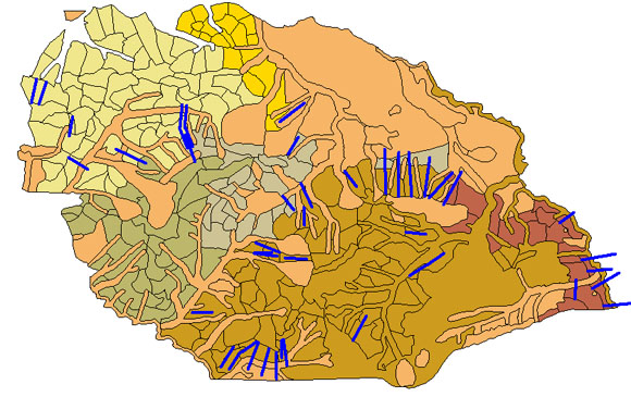
Figure 44: Possible Long Span Yarding Areas.
Also needed was summary statistics for all the profiles delineated as long span yarding. Table 15 shows the maximum, minimum, mean, and total length or all the profiles.
| Minimum Length: | 1012.2 ft |
| Maximum Length: | 2541.7 ft |
| Mean Length: | 1485.0 ft |
| Total Length: | 68307.9 ft |