Chapter 5 The 5103 Bridge Design
5.1 Introduction
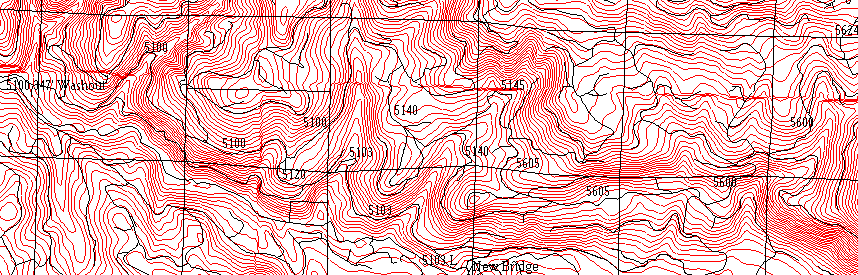
The washouts on the 5100, 5145, and 5140 cause the isolation of a large section of land, 3 621.69 acres, or 5.61 square miles ( Figure 5.1). The volume that used to proceed west down through the 5100, 4600, 4640, and 4100 road path can no longer proceed west, due to the 5100 washout. The washout is a 347 ft. stretch of eroded road that washed completely away to the base of the rock cliff that abutted the road on the uphill side. No econonomical alternative could be established for replacing the washout. We looked at other options for the volume that normally proceeded east to west from the 5100 to the 4600 road. Trial grade lines were run across the 14 Mile creek, trying to connect the 4681 road with the 5102 and 5100 road, crossing it about one half mile upstream. Unstable slopes on the east banks proved unsurmountable. The details of the trial lines ae discussed in Chapter 9.10.
Figure 5.1. Overview map of 5100, 5140, 5145 roads.
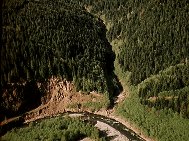
Figure 5.2. 5600 road wash-out at base of the rock cliff, viewed from south looking north. To the left is the fill/culvert failure across the 14 Mile Creek
The volume that used to proceed west, will have to move east to either the new Herrington Alt bridge site, then south to the 4100, before resuming its path west or up to the ridge-top road system. Possible routes out are detaild below.
Option 1. 5100, 5120, 5103, 5103L, West Connector, New Bridge (N.B.) and 4100
Option 2. 5100, 5140, 5605, 5600, 2730, 4250 & out the Ridge top (4200 road).
Option 3. 5100, 5145, 5605, 5600, 2730, 4250 & out the Ridge top (4200 road)..
Option 4. 5100, 5140 5605, 5600, East Connector, New Bridge and 4100
The SNAP model is useful in identifyingthe most economical haul routes based on selected harvest schedules and road costs (both construction and haul costs).
5.2 SNAP Comparisons for Haul Time, Haul Distances,
and Preferred Route
SNAP analysis input parameters included the reconstruction cost for the old 5103 road grade, the bridge needed (5103 bridge, conservative estimate at $90 000) to proceed to the west connector and the new bridge site for option one. Option two (5140 crossing) and three (5145 crossing) both had input parameters including 72"x70’ culverts. Option 4 was also available as a possible route allowing the timber to bypass 5103 and its bridge cost in favor of the culvert crosssing (5140) but longer travel distances.
The solution provided in the SNAP analysis selects the 5103 bridge crossing, eventually going across the new bridge location and out the 4100 mainline. For all activities East of the 14 Mile creek timber will continue to use the 5103 bridge link throughout the periods. Only much later into the schedule is the upper crossing (5145) built to expedite the movement of timber harvest in the immediate vicinity of the 5145 crossing.
The design path for the first option (5103) is contingent upon the availability of the New Bridge location. Analyses where the New Bridge link was not made avialble forces timber haul to the ridge-top road system. In that case timber from the East of 14 Mile creek uses options 2 and/or 3. (5140 and/or 5145 roads). The 5103 bridge crossing is not used at all.
Curently DNR scheduled the replaement of the 5140 culvert washout to be rebuilt.
We advise against the building of the 5140 and the 5145 options. SNAP does not consider the cost for maintenance in the possibility of future washouts. If the 5145 option were to be built in a later period, as SNAP suggests, the increased risk of washout on the 5103 option would be high. The most likely scenario for the past washouts was that the 5145 crossing failed taking out the 5140 and 5103 crossing with it (Figure 5.1).
As we have found through analysis, the 5103 is the most important design path for the volume in this region. We, therefore, believe that the 5103 option should be built first, and that the 5145 option should be considered for future use, but with caution. If the 5145 fails due to debris blockage in the culvert, it will put the 5103 design at greater risk for failure, as the built up debris will cascade into the 5103.
5.3 Bridge Design
5.3.1 Preface
Having established the 5103 option as essential, we considered two possible crossing options, a bridge, or an open arch culvert. The use of an open-arch culvert would allow the design of a curve across the creek, thereby minimizing excavations on both sides into the steep sidehills. Alignment is severly constraint by steep slopes on both sides. Using a bridge in the design requires appropriate bridge deck width to allow the rear end of trailer (e.g. lowboys - off-tracking) to enter onto the bridge deck or allow for access tangents of at least 25 ft to allow truck-trailer combination to align such that standard bridge deck widths can be used.
The open arch culvert advantages included a lower cost, due to less alignment excavation, and lower material and installation costs. The disadvantage for the culvert was the insufficient safety factor, given the amount of debris that may potentially wash out from the upper locations during a storm event. Considering the cost of future maintenance and the probability of large debris cascades, we rejected the arched culvert as an option in favor of a bridge design.
![]()
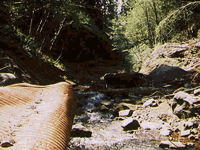
Figure 5.3. View of channel, looking downstream. Portion of failed culvert visible.
5.3.2 Bridge Design Parameters, General Considerations
DesignVehicle. Lowboy. Given the large area west of the 5103 bridge (over 3000 acres) a considerable amount of construction and yarding equipment would be brought in over time. Given that timber volume it was felt that lowboy combinations should be able to negotiate curves and bridges without undue delay or manouvering.
Lowboy width 8 ft.
Tractor length (Front axle to centerline drivers) 18 ft.
Trailor length (Fifth wheel to centerline trailor tandems) 36 ft.
Fifth wheel position (Ahead of centerline driver) 1ft.
Design Speed. We wished to keep the design speed into and across the bridge about 5-8 MPH.
Grade Limits. Grades were not to exceed (+-) 4% for a minimum distance of 50 ft. into and out of the bridge . The grade was not to exceed 3% on the bridge. The grade change at the bridge entry and exit is not to exceed 4%. The grade change at the border of the 50 ft. lead in and exit distances from the bridge cannot be greater than 4%.
Curve Radii. The lower limit on curve radii was 80 ft. Lower radii would make for excessive curve widening conditions when the design vehicle, in this case a lowboy, attempted to track around the curve. The design speed for an 80 ft. curve is 8 MPH. This is the slowest design speed we were willing to negotiate to minimize earthwork, in the trade off of cost for excavation vs. loss in haul time.
Alignment Alignment and design were constraint by the steep slopes on the west side and the desire to catch the natural bench with the road. In fact the existing road uses that bench on the west-side of the creek. The difficulty in the design was that the old design used a fill (with a 6 ft culvert) across the creek, allowing the creek to be crossed with a curve. In our design a bridge was a design input, therefore access tangent or adequate bridge deck width are of paramount concern to allow for oftracking of the vehicle combinations. The design approach taken was to forego access tangents of any length since that woud result cutting into the steep slope on the west side that consists of rock. Rather the bridge deck would be widened to allow for off-tracking.
5.3.3 Design Results
Curve Radii. The curve radius on the west bridge entry was 100 ft. The curve radius on the east bridge exit was 115 ft. Offtracking was used to check curve widening. There was no place in the stationing where the curve widening was larger than the design width of 20ft. for the running surface of the road.
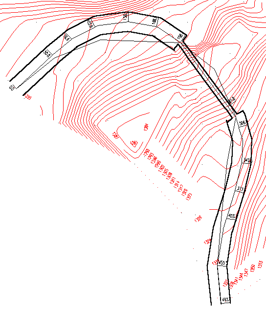
Figure 5.7. Plan view of 5103 bridge design.
Grade Limits. The grade, west to east (loaded), in the west approach 50 ft. out from the bridge was -8%. The grade (loaded) out of the east approach, 50 ft. from the bridge was 6%. The grade change at 50 ft distance west of the bridge was 4%. The grade change at the 50 ft distance east of the bridge was 4%. The grade was -2% on the bridge. The grade change at the bridge entry was 2%. The grade change out of the bridge was 4%.
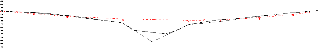
Figure 5.8. Profile view 5103 bridge design and p-line.
Excavation. The total cut volume for excavation was 1897 cubic yards.
Curve widening was calculated using the program Offtracking. There were no sections of the road that needed widening beyond the 20 ft. design width for the road. Offtracking did reveal that the bridge width needed to be 18 ft. wide due to the curve widening leading into the west end exit.
Bridge dimensions. The design results in 95 ft long bridge span with about 5 to 10 ft abbuttments. The bridge deck width required is 18 ft. This is based on 16 ft maximum trackwidth at both bridge exits as established from off-tracking analysis plus 2 ft for driver error (or "wandering") for the lowboy dimensions given above.
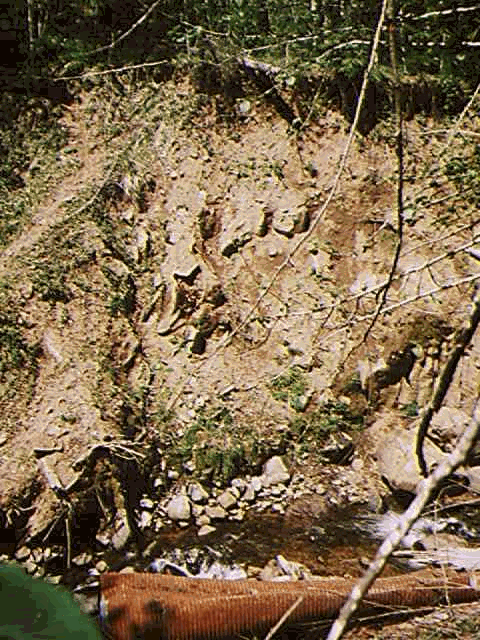
Figure 5.5. View across channel from west to east with the failed culvert/fill visible at the bottom
5.3.4 Bridge Cost
We consulted the contact listed in the FEMA report for prices on Hamilton EZ bridges. He could not quote a price for the bridge with an 18 ft wide running surface, as bridges greater that 18 ft. in width require special designs that, in turn, determine the prices. We were able to get a price quote for a 100 ft. long by 16 ft. wide bridge. The cost for this bridge would be $87 000. The cost for an 80 ft. bridge with a 16 ft wide running surface is $67 000.