Chapter 6
4100 Alternative Route FEMA Points Seven through Eleven
6.1 Introduction
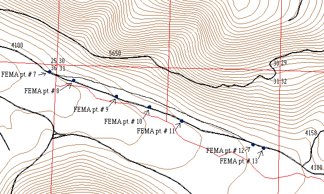
The present 4100 mainline is located in the flood plain of the South Toutle. The Department of Natural Resources is in the process of receiving FEMA funding for the reconstruction of fourteen damage zones, ranging from new culverts and road cleanup, to new road and bridge location. The DNR has expressed interest in rebuilding the existing road system by minor road realignment and bridge work where needed. The geographical scope of this portion of the report concerns the densest portion of the flood damage, FEMA damage points seven through eleven. Please see figure 6.1., below.
Figure 6.1. FEMA project and bypass overviews.
We feel that the best design for this section of the 4100 mainline will involve complete relocation for the FEMA damage points eight through eleven. FEMA point 7 will remain where it is. To recapitulate the damage to the 4100 is listed in the FEMA report is as follows:
FEMA Project 7: Large debris flow from 5650 road above. Approximately 300 ft. length of the stream channel is filled with the debris.
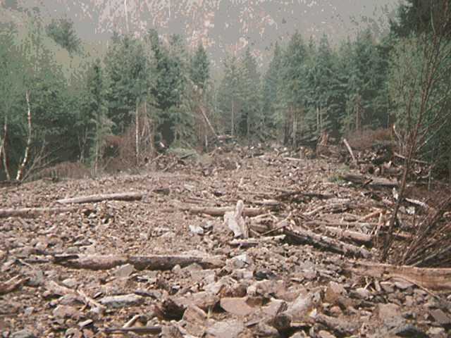
Figure 6.2. FEMA 7, on east side of the 4100 looking north into the main body of the slide.
FEMA Project 8: Road washed away, approximately 225 ft. long by 6 ft. wide.
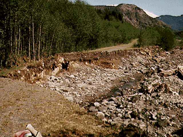
Figure 6.3. FEMA 8, on west side of 4100 looking east to the back end.
FEMA Project 9: Road washed away, approximately 100 ft. long by 5 ft. wide (no picture)
FEMA Project 10: Road washed away, approximately 1000 ft. 60" x 60’ cmp washout out, embankment 20 ft. long by 8’ in depth washed out.
Figure 6.4. FEMA 10, on east side of road looking west.
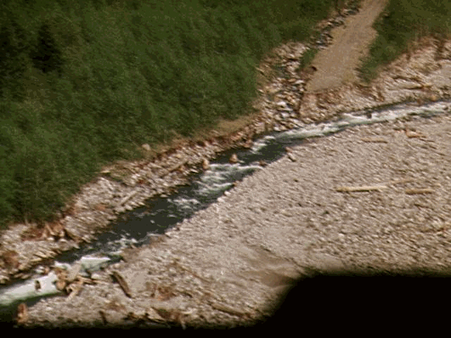
Figure 6.5. FEMA 10, viewed from the southwest, looking northeast.
FEMA Project 11: Road washed away, approximately 150 ft. long by 12 ft. wide.
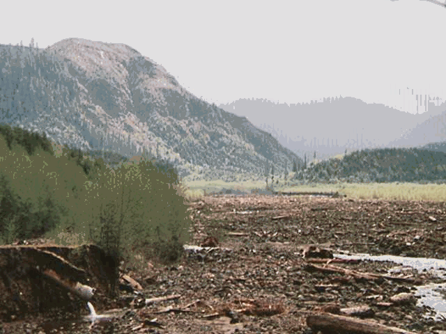
Figure 6.6. FEMA 11, on west side of the 4100 looking east.
The severity of the washouts and the frequency and probability of future washouts prompted us to look for a permanent solution to the problem. First it is important to inspect the proposed solutions as listed in the FEMA report.
FEMA Project 7: Need to replace 72 in. cmp with 84 in. cmp. Need to construct new grade for approximately 300 ft. Excavate the stream channel and dig a catch basin. Need to install an 84 in. by 50 ft. cmp. Need to remove the woody debris from road. Use on site gravel for road surfacing.
Total Cost Estimate = $11 234
State share at 33.3% = $3 741
FEMA Project 8: Need to relocate 300 ft. of the road 10 ft. north, away from the river. Need to reslope the river bank - riprap protection for 300 ft. length, at a 10 ft. depth. Replace 24" x 34’ cmp.
Total Cost Estimate = $12 036
State share at 33.3% = $4 008
FEMA Project 9: Need to relocate 300 ft of the road 10 ft. north. Need to provide pit run rock. Need to reslope the river bank - riprap protection for 150 ft. length, at a 5 ft. depth.
Total Cost Estimate = $6 204
State share at 33.3% = $2 066
FEMA Project 10: Need to relocate 1200 ft. of the road 30 ft. north. Provide two 18" x 34’ cmp. Provide pit run surfacing. Armor the river bank for approximately 300 ft. at a 4 ft. depth. Need to provide a 60" x 60’ cmp, and replace the embankment. Provide pit run surfacing.
Total Cost Estimate = $20 037
State share at 33.3%= $6 672
FEMA Project 11: Need to relocate 200 ft. of the road 15 ft. north. Need to reslope the stream bank and provide riprap 200 ft. at a 10 ft. depth.
Total Cost Estimate = $8 749
State share at 33.3% = $2 913
The total cost for FEMA Projects 7 - 11 is $58 260. The total State cost is $19 400. The proposed relocation has the potential to be a constant and costly problem. We therefore, proceeded to look at other options. After reconnaissance we were able to decide on the best design option. Our design completely relocates the road north, out of the flood zone. The design bypasses the 1475 ft. of washed out road constituting FEMA Projects eight through eleven. Our design does not bypass FEMA Project 7.
6.2 Design Objectives and Results
Having taken care of the primary objective regarding relocation out of the flood plain, our design needed to meet further parameters suitable to mainline haul restrictions. The design speeds were to be maximized. One of the objectives in design was to keep speeds in the range of 30 to 35 MPH. We were trying to limit our curve radii to a 20 MPH minimum. This corresponds to a curve radius of 300 ft. Grades were not to exceed 6% adverse, and 9% favorable to keep 20 MPH speeds. Not all sections of our design were able to meet these parameters. Our design vehicle for curve widening calculations was a lowboy (see Chapter 5.3.3.). The road template parameters included a running surface of 20 ft. width corresponding to the needs of a main line road. The ditches were set to a 1 ft depth and a 3 ft. width. Cut slopes were 1:1, and fill slopes were 1:1.5. All daylight distances for substantial cuts were to be 20 ft. from the road centerline. The template road width provided for a wide enough running surface, and curve widening was not needed on any part of the design. The following results show that most of these parameters were achieved. This part of the report is broken up into four sections Speed, Construction, FEMA Project Seven, and Economic Comparison.
6.2.1 Speed
Alignment and grade were chosen during reconnaissance to aid in the design of a mainline that would allow haul speeds of 20 to 35 mph. The road is broken up into four sections that reflect the geographic difficulty in obtaining the design speeds. The first section is the alder flat near FEMA Project 11. This corresponds to L-line stations
0+00 - 09+77. Grades are favorableranging from 4 -5 percent with no curves (Table 6.1). The speed in this section is controlled by grade. The second section is somewhat difficult due to the rock formations and tallus slopes on the up slope side of the road location. This corresponds to L-line stations 09+77 - 26+30. The speed in this section is controlled by horizontal curvature with radii averaging about 200 ft. The smallest curve radius of this section is 150 ft. Offtracking results showed no need for curve widening. There is an adverse grade of 3 to 6 percent from stations 9+50 to about 15+00 that changes to a favorable grade from about 4 to 5 percent.
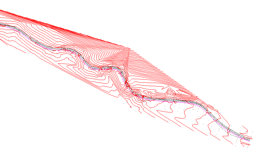
Figure 6.7. Plan view of east half of 4100 alt. Fema Point 10 is near the beginning of the road or in the lower right corner of the picture. Haul is from east to west or right to left.
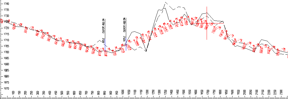
Figure 6.8. Profile view of the east half of the 4100 alt design. Haul direction is from left to right
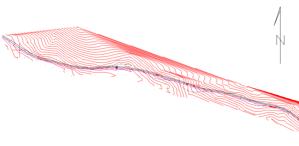
Figure 6.9. Planview of west half of 4100 Alt, haul is from east to west or right to left
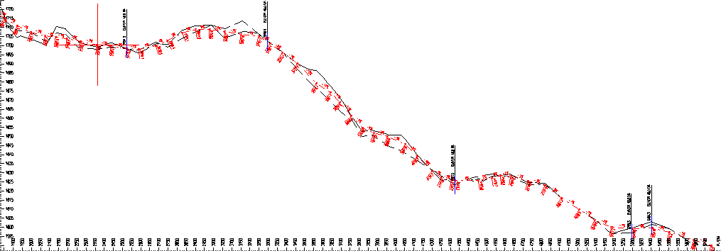
Figure 6.10. Profile view of west half of 4100 alt. Haul direction is from left to right
The third section is relatively free of curves with easy road building. This corresponds to L-line stations 26+30 - 35+16. The speed in this section is controlled by grade. The fourth section is another difficult section due to steeper, favorable grades (up to 11 percent for short stretches) that are a result of the need to improve alignment. This corresponds to L-line stations 35+16 - 37+52. The speed of this section is controlled by grade. The fifth section is easy road building . This corresponds to L-line stations 37+52 - 56+80. The speeds are controlled by grade.
Table 6.1. 4100 Alternative road data.
|
Section |
L-Station |
MPH |
Speed Control |
Ave.Rad. (ft) |
Grd. Range% |
|
Section 1. 0+00- 09+77 |
0+00-9+77 |
30-35 |
Grade |
N/A |
-4% to 5% |
|
Section 2. 09+77-26+30 |
09+77-13+62 13+62-15+88 15+88-18+87 18+87-26+30 |
15-20 10-15 20-25 20-25 |
Alignment |
216 |
-6% to 5% |
|
Section 3. 26+30-35+16 |
26+30-28+42 28+42-31+92 31+92-35+16 |
20-25 30-35 20-25 |
Grade |
N/A |
-9% to 4% |
|
Section 4. 35+16-37+52 |
35+16-37+52 |
10-15 |
Grade |
N/A |
-11% to -10% |
|
Section 5. 37+52-56+80 |
37+52-39+67 39+67-41+67 41+67-47+72 47+72-50+45 50+45-56+80 |
25-30 20-25 30-35 20-25 30-35 |
Grade |
N/A |
-9% to 2% |
6.2.2 Construction
The reconnaissance objectives were to limit the amount of new road needed, in light of the need for a permanent solution to the flood plain damage. The amount of new road was therefore minimized in light of the cost of road construction. Alignment becomes a key issue when designing for minimal road length. The earthwork for straight alignment was weighed against the amount of new road built due to curves around difficult terrain. Section 2 and section 4 required substantial earthwork to improve alignment. The mass haul analysis shows excessive yardage from stations 12+50 to 13+50 and also from 16+00 to 18+00. The Roadeng section views revealed adequate sites along the high mass haul stations with most of the stations corresponding to 30-50% side slopes, with stable ground types. End haul should not be an issue. Please see the Roadeng section notes for the stations mentioned above. As a side note, the road template used had a running surface of 20 ft. width. The ditches were set to a 1 ft depth and a 3 ft. width. Cut slopes were 1:1, and fill slopes were 1:1.5. All daylight distances for substantial cuts were set to be 20 ft. from the road centerline.
Fill slopes were not to exceed a vertical height of 20 ft. There is one design station that is close to this limit. The L-station is 11+89. The side slopes at this station are -15% left, and 37% right. We do not perceive problems at this station. The ground at both the stations ahead and behind have stable side slopes.
Culverts were to be placed at approximately 80 ft. vertical drops in elevation. Our survey notes determined the location of the stream culverts. The profile view obtained from Roadeng revealed drainage patterns for cross drain culvert locations. The L-stations for the culverts are given as follows:
08+51 = 48 in. cmp
10+27 = 48 in. cmp
24+72 = 24 in. cmp
32+55 = 48 in. cmp
43+04 = 24 in. cmp
54+08 = 48 in. cmp
This culvert density is more than the minimum culvert requirement for 80 ft. elevation drops.
There is an old rotational failure that is older than 300 years between stations 12+71 and 16+58. The ground has not moved in the last several hundred years as indicated, on site, by the old growth stumps.
6.3 FEMA Project Seven
FEMA Project seven is a specialized problem. The debris fan (54+08 to 56+36) poses a special maintenance problem. As part of the damage survey as documented in the FEMA report the team proposed the installation of a 7 ft diameter culvert in combination with the construction of a large catch basin above the culvert inlet. Given the grade of the road substantial excavations would be required both for the culvert installation as well as the catch basin. The unconsolidated material would become de-stabilized and continually sluff into the catch basin because of steepend stream gradients as well as cut banks around the catch basin.
We propose a different approach.. The watershed tributary to the culvert is not large. Culvert failure at the time was not caused by an extreme flow event but by a debris torrent created by a rock/slope failure above which also took out a road fill above the crossing in question. The stream and streamflow can be handled by a 4 ft diameter culvert, even large extreme flow events. A normal-sized catch basin with trash rack above the culvert inlet should handle extreme flow events. To protect the road itself the template should be adjusted. Proposed is an oversized ditch such as 3 ft deep with a 4 ft bottom and 2:1 slopes rip-rapped with rock. The ditch line can then serve as a catch basin for perennial sluffing of the material and the occasional, above average flow event. Should a larger event such as a debris torrent occur, it might overflow on to the road surface. By hardening the surface, similar to a ford crossing, the road could be cleared with little effort.
6.4 Economic Comparison
The new road location is comparable in price to the FEMA cost analysis. All costs derived in the analysis are from the cost model of the USDA Forest Service Cost Estimating Guide for Road Construction October 1993, Region 6 Format, Zone 1 National Forests, Davis-Bacon Area 2 publication.
6.4.1 Clearing, Grubbing, and Slash Disposal
The costs for clearing, grubbing, and slash disposal are $724.53, $1846.64, $1327.11, respectively. Please see Table 6.2, below. The timber on sight during the construction period is unmerchantable timber. The grubbing cost has been separated into three categories. The categories correspond to the side hill slope percentage. The analysis in Roadeng revealed the breakdown in percentages. Most of our design falls within the under 30% category, stations 0+00 to 09+77, and 26+30 to 56+80. The second largest category is the 30-50%. Most of this corresponds to the stationing 09+77-26+30. 50% and above was occasionally dispersed in the stations 09+77-26+30. Slash was figured with a light windrow const. slash title.
Table 6.2. Operation costs, clearing, grubbing, slash.
|
Operation |
Cost $ |
||||
|
Clearing UnmerchantableTimber |
14028.8 |
||||
|
Grubbing |
1846.635 |
||||
|
Under 30% @ $396/Ac |
|||||
|
30 - 50 % @ $441/Ac |
|||||
|
50% and above @ $234/Ac |
|||||
|
Slash |
1327.106 |
||||
|
Windrow Const. slash @ $294/Ac |
|||||
6.4.2 Excavation and Seeding
The total excavation cost for the length of the road (56.8 Stations), was $21 964. This cost was based on the figures given in the costing guide mentioned above. The manual gave prices for the two types of excavation that correspond to our design. Stations 0+00 to 9+77 and 26+30 to 56+80 were all common excavation. Stations 9+77 to 26+30 were rippable rock excavation. Please see Table 6.3., below.
Table 6.3. Operation costs, excavation, seeding.
|
Operation |
Cost$ |
||||
|
Excavation Cost |
21964 |
||||
|
Type |
Basic Unit Cost (cyd) |
||||
|
Common |
$1.24 |
||||
|
Rippable Rock |
$2.15 |
||||
|
Seeding |
1183.09 |
||||
|
Purchase Cost |
|||||
|
Seed |
100.32 |
||||
|
Fertil. |
66.88 |
||||
|
Hay Mulch |
304 |
||||
|
Subtotal |
471.2 |
||||
|
Cost for application |
|||||
|
Seed |
121.8443 |
||||
|
Fertil. |
140.1209 |
||||
|
Hay Mulch |
449.92 |
||||
|
Subtotal |
711.8852 |
||||
The costing guide assumed that 40 lbs. of seed and 200 lbs. of fertilizer will be applied per acre. Furthermore the dry mulch method assumes that 4 000 lbs. of dry mulch will be used also. Using Roadeng, and Excel, an estimate for the total cut and fill area for seeding was calculated at 1.52 acres. 60.8 lbs. of seed, 304 lbs. of fertilizer, and 6080 lbs. of mulch will be needed. The cost for the seed, fertilizer, and mulch, on a per pound basis was $1.65, $0.22, and $0.05, respectively. The cost for application for the seed was $80 per acre. The cost for application for the fertilizer was $92 per acre. The cost for application for the mulch was $74 per thousand pounds. The total seeding costs were $1183.09. Please see Table 6.3., above.
6.4.3 Ballast and Culverts
The costs for ballast and culverts were the largest component of the economic analysis. The estimate for ballast given by Roadeng was 4081.8 cubic yards. The ballast estimates were based on a road template with a 20 ft. wide running path, and 12 in. deep ballast depth. The length of the road was 56.8 stations. From the computed ballast volume, at a cost (given by the costing guide) of $8.50 per cubic yard, the total cost of the ballast was $34 695.30. Please see Table 6.4., below.
Table 6.4. Road costs, ballast and culverts.
|
Road Costs |
Cost$ |
||||
|
Ballast |
@ $8.50/cyd |
34695.3 |
|||
|
Culverts |
5442.12 |
||||
|
08+51 = 48 in. cmp |
48" x 24’ |
1087.2 |
|||
|
10+27 = 48 in. cmp |
48" x 24’ |
1087.2 |
|||
|
24+72 = 24 in. cmp |
48" x 30’ |
1359 |
|||
|
32+55 = 48 in. cmp |
24" x 24’ |
821.52 |
|||
|
43+04 = 24 in. cmp |
48" x 24’ |
1087.2 |
|||
|
54+08 = 48 in. cmp |
Total = |
5442.12 |
|||
The total cost for the culverts is $5442.12. The costs for the culverts were based on the costing manuals prices for galvanized, round, aluminum pipe, at 0.60 thickness (16 gauge), with 2 2/3 x 1/2" corrugation. The 24" cmp was $19.56 per foot. The 48" cmp was $45.30 per foot. Please see Table 4 above, for the cost breakdown of the various culvert lengths.
6.4.4 Economic Summary
In summary the cost breakdown for each of the operations and road costs is listed below in Table 6.5. Please note the percentages of each category. This is a percentage of the total cost of the project which is $67 182.77.
Table 6.5. Cost Summary
|
Cost Breakdown |
Dollars |
$/Sta. |
%of Total |
|||||||
|
Clearing Unmerchantable Timber |
724.52 |
13 |
1.05 |
|||||||
|
Grubbing |
1846.64 |
33 |
2.68 |
|||||||
|
Slash |
1327.11 |
23 |
1.93 |
|||||||
|
Excavation Cost |
21964.00 |
387 |
31.91 |
|||||||
|
Seeding |
1183.09 |
20 |
1.72 |
|||||||
|
Ballast |
34695.30 |
611 |
50.41 |
|||||||
|
Culverts |
7089.36 |
96 |
10.30 |
|||||||
|
Total Cost |
68830.01 |
1183 |
100.00 |
|||||||
Figure 6.9. 4100 Alternative Route Design Cost Summary
The proposed FEMA plan for the reconstruction of points seven through eleven had a total cost of $58 260, total. The plan proposed above is $8 922.77 dollars more. The competitive nature of the cost for our design is a positive attribute, especially when viewed in the long term. The security of our design is well above the proposed FEMA plan of relocation within the flood plain. Given another unforeseen flood event, the cost of maintenance for the FEMA plan would more than likely exceed the $8 922.77 invested now. It is our opinion that the our design option will save the DNR money in the long run, as its maintenance will not be a function of the South Toutle’s drainage patterns.