Chapter 8 - South Toutle Bridge Location and Approach Design
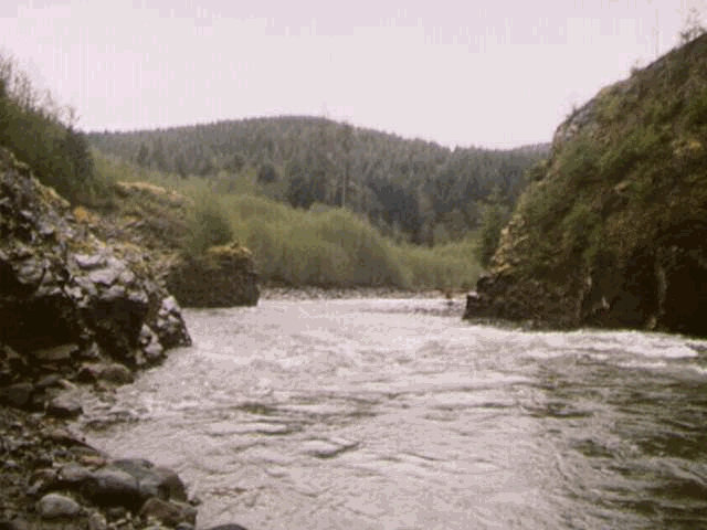
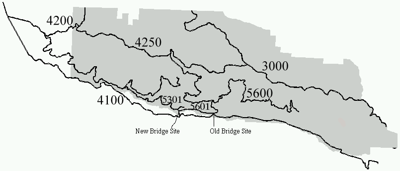
Recent heavy storm/flood events in the Toutle area precipitated many road washouts and bridge failures, seriously limiting access to and management of the Toutle Block (Figure 8.1). Probably the most critical of these failures was the loss of the Herrington Bridge crossing of the South Toutle River (Figures 8.2 ). The loss of this crossing disabled the link between the segments of the 4100 mainline on the north and south sides of the South Toutle River, limiting administrative access to and transport of timber from areas east of the bridge crossing.
The Herrington Bridge crossing cannot be rebuilt due to environmental concerns of damage to fisheries and coarse sediment inputs. In particular, with little potential for clearance above the river and long approaches in the flood plain, this location is susceptible to future flood events and shifting of the river channel. The infeasability of this site necessitates the development of a new crossing site that provides the same transportation benefits while providing a greater degree of protection against storm events and environmental degradation.
Figure 8.1. Overview of main roads in Toutle Block including location of old and new South Toutle bridge crossings.
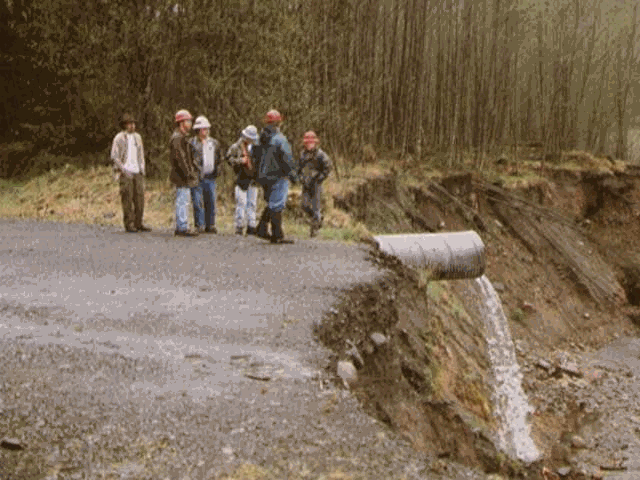
Figure 8.2. Failed Herrington Bridge Crossing (Old bridge site). View shown is the end of the south bridge approach.
The objective of the search for a new South Toutle River bridge crossing is to develop a new mainline connector between the north and south 4100 with a high level of stability and potential for approaches that allow a road standard compatible with high-volume truck traffic.
8.2.1. Reconnaissance/Location
The initial phase of reconnaissance involved the analysis of map and aerial photo resources. This was supplemented by limited field reconnaissance by Department of Natural Resources personnel. In general, there are few potential bridge sites available in the appropriate area. Most areas are too wide for a reasonable span length or too low to provide the desired clearance. In addition, many areas consist of unstable material and have poor potential to provide high standard (defined in 8.3.1.1.) approaches.
The initial site identified as a potential new bridge site was rejected during field reconnaissance. Though rock on the south side provided a good base for abutments, the north side consisted of highly erodible sand bluffs. To provide a stable location, a long span would have to be installed to place the north abutments on stable material. In addition, the potential for high standard approaches on the north side is very limited due to severe terrain constraints. The approximate location of this site is shown on Figure 8.3 as a brown dot just east of the new bridge site.
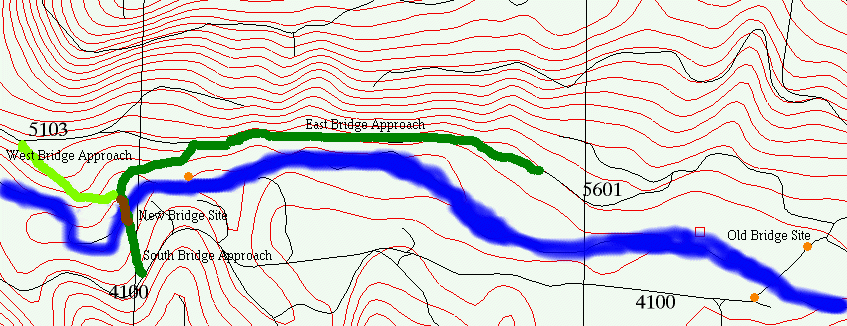
Figure 8.3. Overview of local area near the new bridge site.
After rejecting the initial site, the field reconnaissance team continued to search for a potential bridge location along this area of the river. The recommended site was located just west of the initial site (Figure 8.3). This site provides all of the attributes necessary to provide a high standard link between the north and south 4100 mainline. Rock on both sides of the site provides a stable base for bridge abutments. The height of the rock outcrops will provide good clearance (>20 feet) for high flow and debris passage. The width of the span is reasonable (approximately 100 feet) and the surrounding terrain provides reasonable potential for high standard approaches. Various views are shown in Figures 8.4, 8.5, and 8.6.
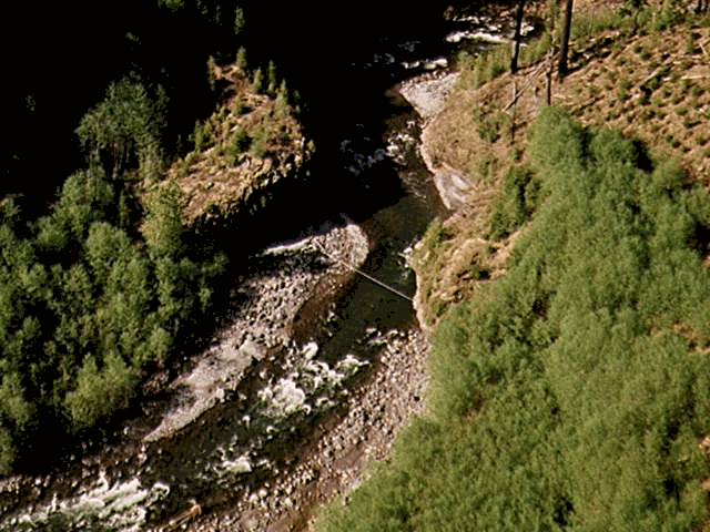
Figure 8.4. Aerial view (upstream) of recommended bridge site.
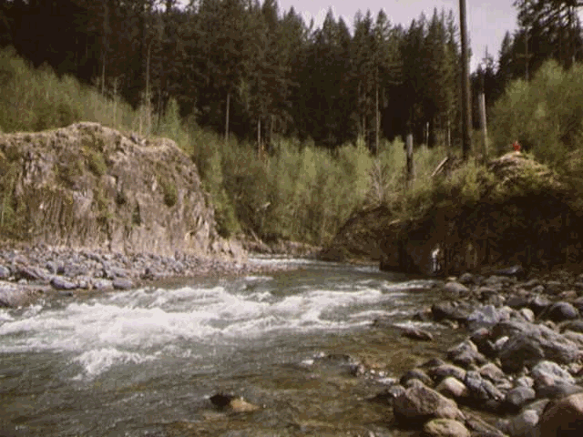
Figure 8.5. Ground view (upstream) of recommended bridge site.
Figure 8.6. Ground view (downstream) of recommended bridge site.
8.2.2. Data Collection
Access to the north side was a significant problem in data collection for the recommended bridge site and the accompanying approaches. To reach the north side using the present road system required a significant drive followed by a strenuous hike through rough terrain. All things considered, this approach would have cut data collection time by 3-4 hours per day. Based on this, it was decided that a method for directly crossing the river at the bridge site should be developed.
After exploring some alternatives for crossing the river, it was decided to set up a crossing using a tight-line with a pulley system and a canoe. Anchors were set on the south side (Figure 8.7) and the river was crossed by canoe. After setting anchors on the north side, a tight-line was established and a pulley system was developed. The canoe could then be ferried across rapidly using this system (Figure 8.8). This system worked quite well and enabled a larger portion of the time available to be used for data collection, though there were moments of anxiety (Figure 8.9.) and one episode of capsizing, in which some personal field gear was lost downstream.
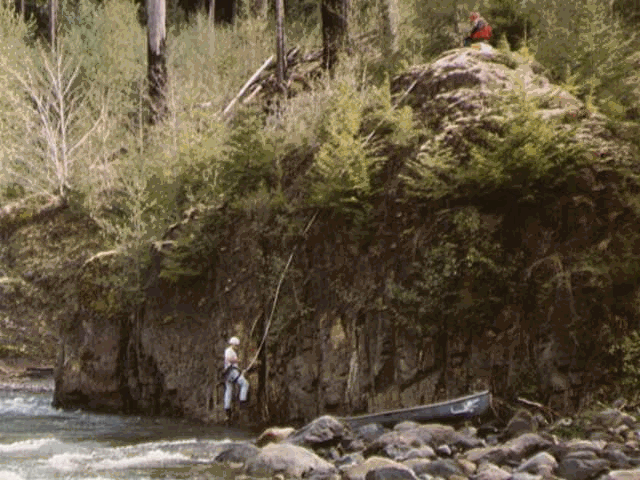
Figure 8.7. Setting tight-line anchors on the south rock face at the recommended bridge site.
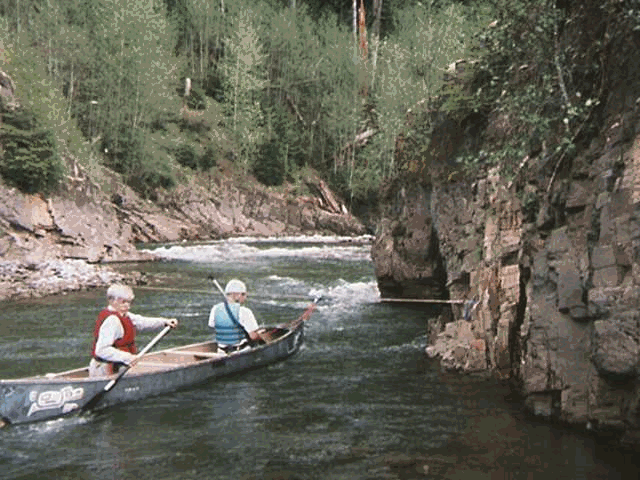
Figure 8.8. Crossing the South Toutle River at the recommended bridge site.
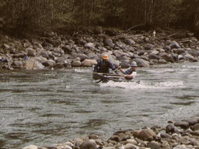
Figure 8.9. A moment of anxiety crossing the South Toutle River.
8.2.2.2. Survey Data Collection
Bridge site and approach data was collected using a Criterion Laser surveying system (Figure 8.10.). In general, this system resulted in efficient collection of accurate data. The perceived advantages and disadvantages of this system are outlined below:
Advantages
Disadvantages
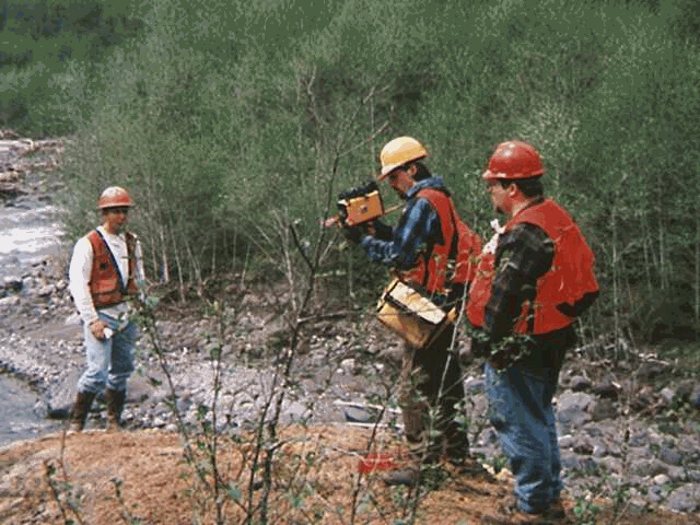
Figure 8.10. Survey crew using Criterion Laser surveying system.
8.3.1.1. East and South Mainline Approaches
The design objective in this case was to develop a high standard road segment to link the north 4100 mainline to the south 4100 mainline through the 5601 road system and the recommended bridge site. Figure 8.11. provides an overview of the area and the location of the bridge and approach routes.
The road standard is essentially defined by the objective travel speed of standard log trucks transporting timber volume out of the area. For this design, a maximum speed of 35 mph was desired. In general, to obtain this speed, the following design parameters were used or attempted in the design:
8.3.1.2. West Approach
The design objective in this case was to develop a secondary road segment to link the 5103 road system to the south 4100 mainline through the recommended bridge site. Figure 8.12. provides an overview of the area and the location of the bridge and approach routes.
The road standard is essentially defined by the objective travel speed of standard log trucks transporting timber volume out of the area. For this design, a maximum speed of 25 mph was desired. In general, to obtain this speed, the following design parameters were used or attempted in the design:
Figure 8.11. Overview of bridge site area and approaches
8.3.2.1. East and South Mainline Approaches
Figures 8.12. through 8.17 provide plan design/contour and profile views of the east and south bridge approaches. Beginning at the east end of the east approach near the 5601 take-off, the primary location constraint was the presence of sand bluffs to the south and rock cliffs to the north. Through the area shown in Figures 8.12. and 8.13., the objective was to maintain a rolling grade with little overall elevation change.
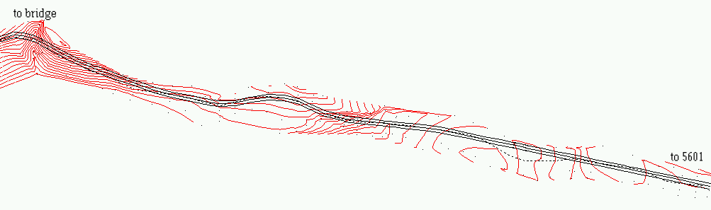
Figure 8.12. Plan view of design/contours of the eastern portion of the east bridge approach.
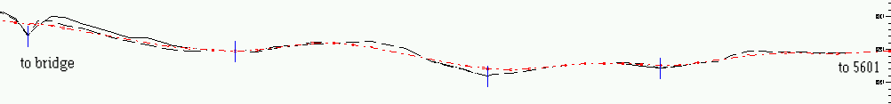
Figure 8.13. Profile view of eastern portion of the east bridge approach.
Through the areas shown in Figures 8.14 and 8.15., the primary constraint was the need to connect with the bridge site at a reasonable grade while crossing the multiple draws in reasonable locations. Near the bridge site, the approach curve radius was limited by the terrain.
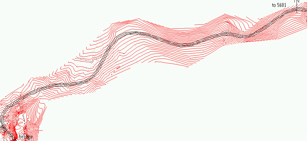
Figure 8.14. Plan view of design/contours of the western portion of the east bridge approach.
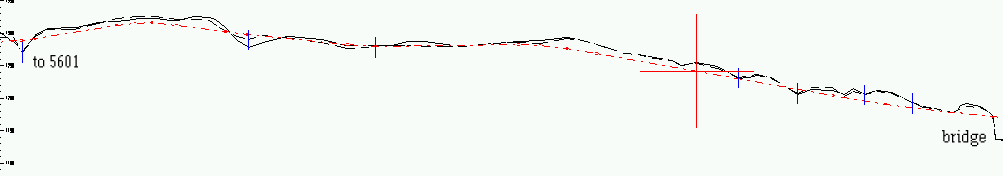
Figure 8.15. Profile view of western portion of the east bridge approach.
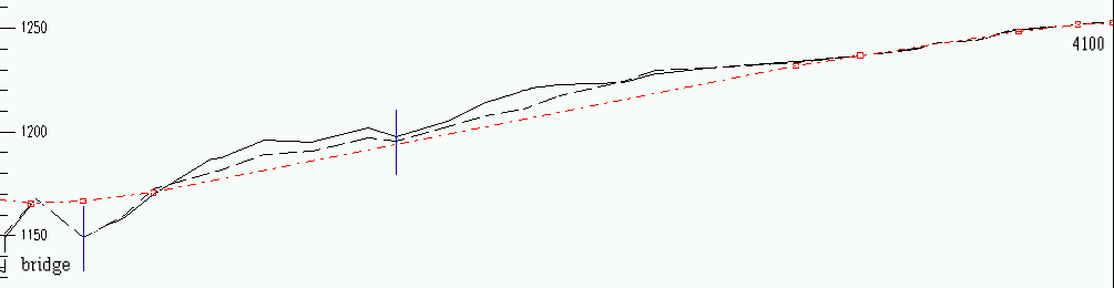
The south bridge approach was primarily constrained by the sideslope terrain immediately south of the bridge site (Figures 8.176 and 8.17) and the need to reach the south 4100 road prior to a major stream crossing.
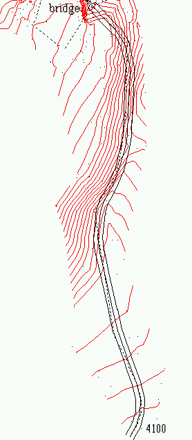
Figure 8.16. Plan view of design/contours of the south bridge approach.
Figure 8.17. Profile view of south bridge approach.
8.3.2.2. West Approach
Figures 8.18. and 8.19 provide plan design/contour and profile views of the west bridge approaches. Beginning at the west end of the west approach, the primary objective was to overcome the significant elevation drop to the bridge site but maintain a reasonable grade. In addition, the presence of rock cliffs (Figure 8.20) to the south constrained the location. Near the bridge site, curve radius was limited by terrain constraints.
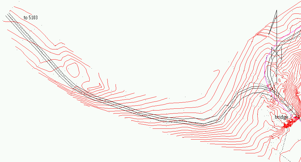
Figure 8.18. Plan view of design/contours of the west bridge approach.
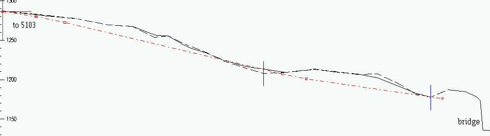
Figure 8.19. Profile view of west bridge approach.
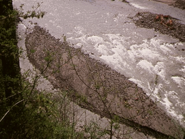
Figure 8.20. View of South Toutle River from cliffs constraining location of west bridge approach.
8.3.3.1. East and South Mainline Approaches
In general, the east and south mainline approaches were located on solid material and should be stable roads with few problem areas. Based on performance data from the Otto program (Chapter 7), the average speed is expected to be around 20 miles per hour (Figure 8.22). This is lower than desired but good considering the terrain constraints placed on the design process. The maximum adverse grade for the east approach is 10% for short sections. 8% adverse grade is the highest for any significant distance. The minimum curve radius is found at the bridge and is 125 feet. The maximum adverse grade on the south approach is 10% and the minimum radius is 121 feet, found at the bridge tangent. Generally, the design process resulted in well-balanced designs for both the east and south bridge approaches.
In general, the west approach was located on solid material and should be a stable road with no problem areas. No performance analysis was performed on this approach because of the secondary nature of the road. The maximum grade is 12% favorable, with no significant adverse grade. The minimum curve radii are found at the reverse curve leading into the bridge tangent and are 92 and 100 feet in the direction of loaded haul respectively. Much of the design calls for full bench construction in fractured rock. This should be a very solid road.
8.3.3.3. Bridge Site
The bridge site location (Figure 8.21) allows for minimum of 100 feet of tangent approach on each side of the bridge. With this tangent length, vehicle off-tracking does not pose an issue and no bridge deck widening is required. The bridge grade is approximately 5%. The east approach curve is of radius of 125 feet, the south approach curve is 121 feet in radius, and the west approach comes in with a reverse curve of 92 and 100 feet radius. Curve widening is required on the west approach reverse curve.
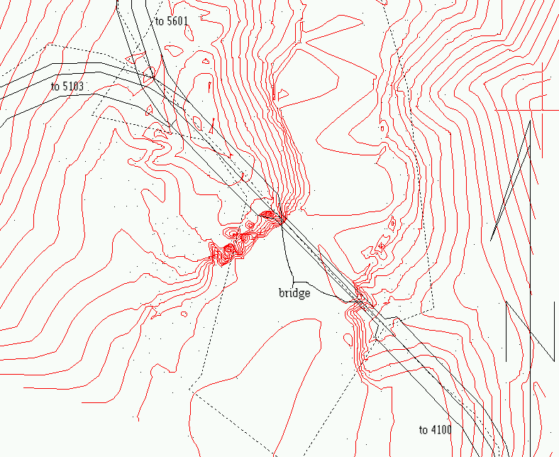
Figure 8.21. Contour view of bridge site area.
A rough estimate of $140,000 for the cost of a 100-foot span concrete bridge was made by conversation with a local, private road engineer. Detailed costing for the bridge is left to those responsible for the actual installation of the bridge site.
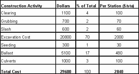
Cost estimates for the construction of the bridge approaches are based on the Forest Service Cost Guide. Generally, all elements of road construction are considered. A summary of costs for each approach is provided in Tables 8.1, 8.2, and 8.3. Clearly labeled spreadsheets containing the calculations for these cost estimates my be found in the digital data directory in the "Costing directory.
Table 8.1. Cost estimate summary for east bridge approach.
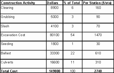
Table 8.2. Cost estimate summary for south bridge approach.
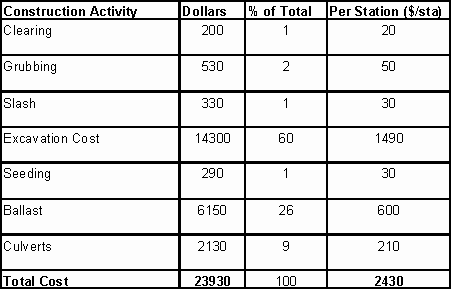
Table 8.3. Cost estimate summary for west bridge approach.
Historically, forest road design has been limited to locating roads based on the lowest apparent cost of road construction that provides for a given purpose. This continues to be appropriate for spur type roads where a relatively small volume of traffic is expected and the necessary life of the road is limited. However, in the design of high volume roads such as mainlines, a higher level of consideration is warranted in providing the highest economic return over the longer life of the road. Often, the lowest apparent cost (construction) is not truly the lowest cost in the long run.
High volume road design should be a balance between design parameters (grade, curvature, and location) and costs (construction, haul costs, maintenance). Location optimization is an issue of the value of a given road location relative to the needs of the user, as measured by truck performance, speed, haultime, and relative to location of adjacent roads. Currently, this aspect is being addressed and implemented to some degree.
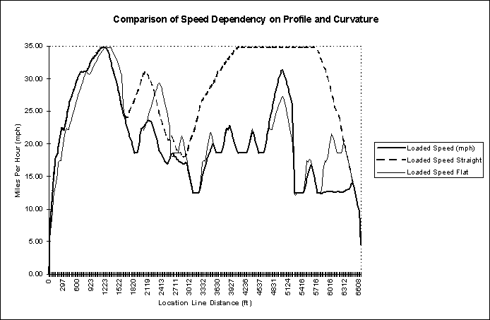
Typically, in forest road design, grade and curvature are addressed as a function of construction costs and truck performance is rarely addressed explicitly. Various standards for grade and curvature have been set by regulation and experience and these are applied generally to all construction projects. This results in roads that are generally limited by either curvature or grade but rarely both. road design data were imported from RoadEng into OTTO. The road design data are arranged in a fom that could be read by the truck simulator program. File structure basically required radius, direction, distance, grade, information that could be easily extracted from RoadEng. As can be seen in Figure 8.22. the speed of the east bridge approach on this project is largely limited by curve radius. Virtually all of the significant drops in speed can be attributed to a relatively small horizontal curve radius at that point. Grade appears to have some effect but overall, the limiting factor on this road is curve radius. Performance data was obtained using the Otto program (Chapter 7).
Figure 8.23 shows the relative speeds of three different travel scenarios for the east bridge approach. The "normal" line is the actual performance of the east bridge approach. The "flat" line is the east bridge approach with a 0% grade throughout but horizontal curvature remaining. The "straight" line is the east bridge approach with no horizontal curvature but the original profile remaining.
Though artificial in nature, Figure 8.24 provides a conceptual look at the limiting factors along the length of the east bridge approach. This type of analysis allows the optimization of the design parameters to a point in which grade and curvature can equally limit the performance and thereby obtaining the best balance for a given location.
For example, from Stations 30+00 through 40+00, curvature is clearly the limiting factor and grade has little effect on truck performance. In this case, the maximum speed of this section could potentially be increased by finding a better balance between grade and curvature. Continuing this as an iterative process, a balance could potentially be found in which grade and curvature limit the maximum speed in a similar fashion, resulting in a higher overall speed and potentially lower construction costs. This type of analysis is necessarily site-specific and may be limited by extreme terrain or other controlling factors.
Little time was available in this project to thoroughly address this issue, but the concept of performance analysis and optimization of road design by an iterative process could potentially be well applied to forest roads. Again, secondary roads do not justify this level of analysis, but in the case of mainline roads, the economic benefit over the life of a high standard road could be substantial.
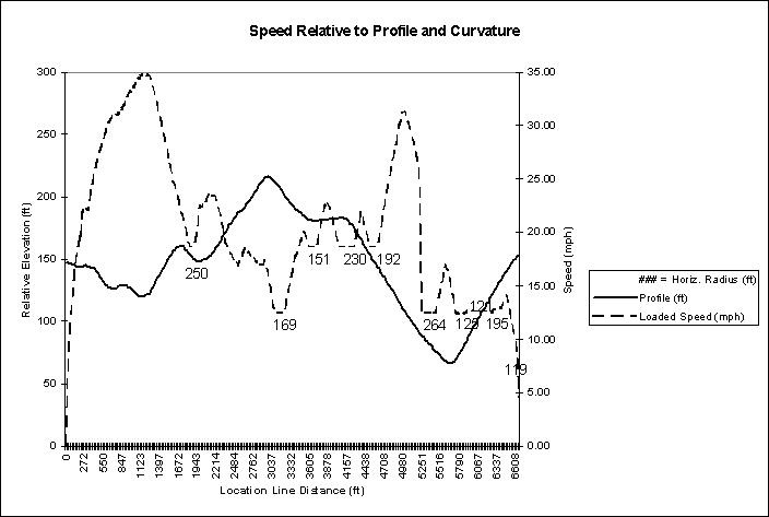
Figure 8.22. Speed and profile vs. L-line station for east bridge approach.