Chapter 9 Reconnaissance Reports
9.1 Weyerhaeuser Potential Bridge Site Area Recon
Location: Approximately 1000 feet southwest of 4100/4158 junction
Background: Access to the 4100 mainline on the north side of the South Toutle River by Weyerhaeuser was closed by the failure of the original bridge crossing approximately 1 mile upriver of the current recon area. This access provides an alternative to circuitous haul routes in moving volume to the Castle Rock area. For environmental/administrative reasons, reconstruction of the original crossing is not possible and alternative sites are being considered. The value of an alternative crossing is significant in avoiding the high haul costs associated with routes located on the south side of the river. This site was chosen as the most likely alternative because of the presence of a rock outcrop that substantially decreases the width of the floodplain at this point.
Procedure: In general, the analysis of this site was limited to visual observations with limited use of an Advantage laser to provide reasonably accurate estimates of vertical and horizontal distances.
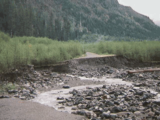
Site Description: The south edge of the floodplain is generally low-profile, erodible material with the exception of the rock outcrop. The rock outcrop appears to be fairly competent on the west and north sides and relatively poor on the east side. The initial face of the rock outcrop is approximately 50 feet in height (from the floodplain). The visible upper face of the outcrop is approximately 20 feet in height but appears to increase in height toward the back. The north edge of the floodplain is consistently low-profile, erodible material approximately 25 feet in height. The width of the floodplain from the rock face to the north edge is approximately 375 feet.
Comments: As the narrowest local portion of the floodplain, this site was considered to be most suitable for a potential bridge site. Though no alternative is available, this site is generally unacceptable as a bridge site. Considering the width of the floodplain, the expense of a full span would be prohibitive. Potentially, a through fill could be constructed on the non-flowing portion of the floodplain and a bridge installed over the flowing channel. Such a structure would require substantial engineering to maintain any chance of integrity during peak flows. The probable and chronic failure of such a structure would pose substantial monetary and environmental risk. In addition to the width of the floodplain, the differential in height (50 feet or more) between the north bank and the rock outcrop would make construction of a bridge site costly, if possible at all. In general, this area is unsuitable as a bridge site and additional consideration of this site is not warranted.
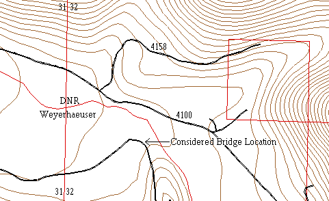
Figure 9.1 Overview of area where the considered bridge site was located
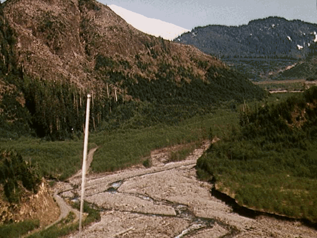
Figure 9.2 Photo of considered Weyerhaeuser bridge site as viewed from west to east
9.2 4158 Rock Knob Attempt
Starting Point: 4158 above large rock outcrop at 4100/4158 junction
Ending Point: At creek to east of rock outcrop
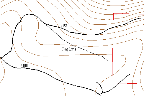
Status: Grade reconnaissance ribbon (orange) running generally west to east / abandoned at creek
Comments: An initial attempt to establish a grade line utilizing the existing portions of the 4158 to bypass the bridge washout (FEMA PT 14) and move the 4100 Road away from eroding banks met with unfavorable results. Soon after taking off of the 4158, the grade line crests the major slope break heading down into the creek drainage. Almost immediately, the slope becomes very wet. Nearly continuous seeps create swampy areas and generally saturate the hillside. Very poor potential for a road site. At the creek, an extremely wide floodplain and multiple braided channels indicate that potential for feasible crossings is essentially non-existent. At this point, the gradeline was abandoned.
Figure 9.3 Schematic of 4158 rock knob attempt
9.3 FEMA #14 Bypass
Starting Point: 4100 just east of the 4158/4100 junction
Ending Point: 4100 east of FEMA PT 14
Status: Reconnaissance ribbon line (orange) running generally west to east.
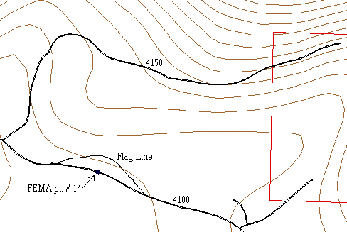
Comments: A short bypass connector with the intent of moving the creek crossing away from the South Fork Toutle River and gaining bridge clearance for debris passage. The estimated length is 500 feet. At the flagged creek crossing (approximately 300 feet from beginning), the estimated bridge length is 60 feet. The surrounding terrain is generally flat and construction should encounter little difficulty. This line was not stationed.
Figure 9.4 Schematic of FEMA #14 Bypass involving a stream crossing (bridge or large culvert)
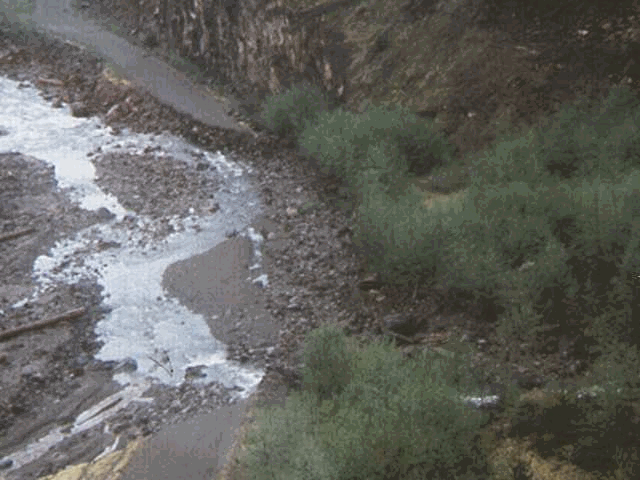
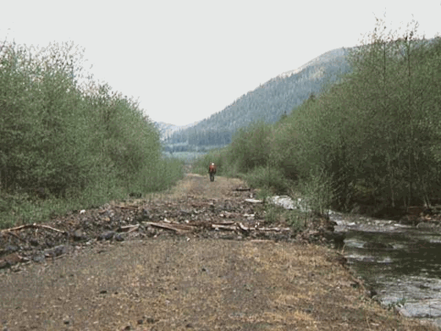
Figure 9.5 4100 foreground looking west to east. 4100 washout in foreground and tributary stream washout in background.
Figure 9.6 Aerial view of FEMA #14
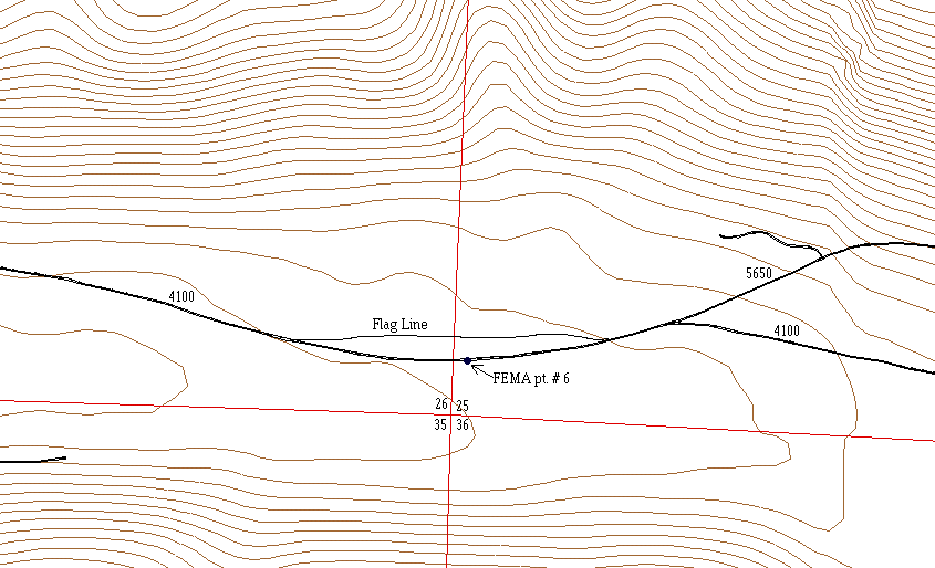
9.4 FEMA #6 Bypass
Starting Point: 4100 at 5649/4100 junction
Ending Point: 4100 west of FEMA PT 6
Status: Reconnaissance ribbon line (orange) running generally east to west
Station and Comments:
0+00 Beginning point
1+60 Minor creek crossing
6+40 Minor creek crossing
12+00 Creek crossing
15+20 End of grade line at 4100
Comments: The intention of this road line is to bypass FEMA PT 6 and move the 4100 mainline away from the banks of the South Fork Toutle River. The terrain is generally flat and construction should proceed with little difficulty and much flexibility. Some portions of the flag line follow old grades. The flag line crosses the creeks at point at which it was perceived that minimal construction would occur.
Figure 9.7 Schematic of FEMA #6 bypass
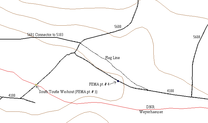
9.5 FEMA #4 Bypass
Starting Point: East end of 5601 at final curve
Ending Point: 4100 east of FEMA PT 4
Status: Reconnaissance ribbon flag line (orange)
Station and Comments:
0+00 Final curve on east end of 5601
1+60 Cross 5600 road
12+00 Creek crossing (10-12 feet wide)
16+40 End of ribbon line at 4100 east of FEMA 4
Comments: The purpose of this road line is to bypass FEMA PT 4 as well as provide a smooth transition from the existing 4100 to the 5601 approach to the potential new bridge crossing of the South Fork Toutle River. The terrain is generally flat and has high potential for easy road construction and maintenance.
Figure 9.8 Schematic of FEMA #4 Bypass involving moving the road north to achieve a better stream crossing
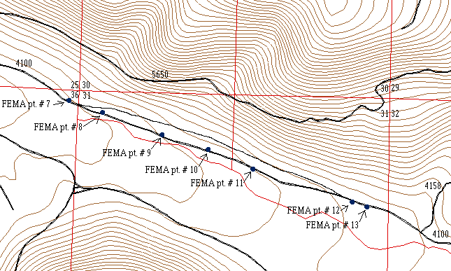
9.6 4100 Bypass
Starting Point: On 4100 West of FEMA report point 12.
Ending Point: On 4100 near FEMA report point 7 just before the debris fan.
Status: Preliminary stake line, orange stakes with flagging for intervisibility. Traverse and design data exists for this road. Proposed for construction.
Stake # and Comments:
01 On 4100 West of FEMA report point 12.
15 Will require culvert, probably 4’.
18 Stream crossing.
27 Beginning of rock slide area from 5650.
28 Center of rock slide area from 5650.
54 Stream crossing.
67 Rock slope/cliff located 50 feet beyond last side shot to North.
68 Log jam located beyond last side shot, continues level for 80 feet.
69 Old cabin site located to North.
77 On 4100 road just East of the debris fan at FEMA point 7.
Comments: The continued presence of the main channel of the South fork of the Toutle on the North side of the flood plain, in many instances where the 4100 was previously located makes reconstruction at the existing location impossible. This relocation both limits the possibility of future damage from the river, but also allows stream crossings that will be less prone to wash outs.
Figure 9.9 Schematic of 4100 Bypass flag line
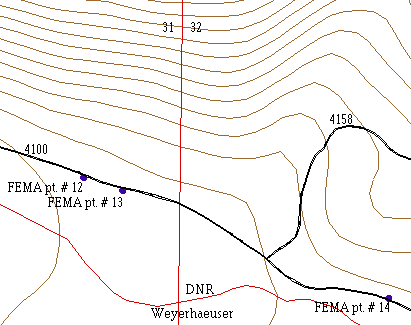
9.7 FEMA #12 and #13 Bypass
Starting Point: 4100 and 4158 junction
Ending Point: West of FEMA pt. # 12
Status: Various abandoned flag line segments on the west side of the stream crossing, and one reconnaissance ribbon line on the east side of the stream crossing.
Comments: No feasible crossing of the creek to the west of the 4158. Creek banks steeply incised and approaches requiring tight curve radii on steep side slopes. Creek crossing across a debris fan requiring substantial construction, which might be susceptible to future debris torrent. Debris fan will act as a settlement area reducing speed and delivery potential from above.
Recommendation: Follow recommendation in the FEMA report for points # 12 and # 13. Repair and reinstall culvert at point # 13 would redirect stream into original channel, and divert it from it’s current course which currently parallels the 4100 ditch line.
Figure 9.10 Schematic of area containing FEMA pt. # 12 and 13
Figure 9.11 FEMA #12 view east to west on 4100. Stream in ditch line caused by plugged culvert at FEMA #13. By restoring culvert at pt. # 13, water will be reverted to original channel
9.8 5100, 5120, 5103, 5103 L (inspection of existing road system)
Starting Point: 0+00 is the Fourteen Creek Washout
Ending Point: 250+00 is the 5103 L end of construction
Status: Reconnaissance ribbon flag line (orange line for grade)
Station and Comments:
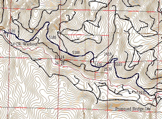
0+00 14 Cr. washout
35+00 Side cast failure (shoulder only). West (uphill) is the beginning of a rock outcrop. The road can be shifted slightly uphill into the rock outcrop.
59+00 West side at the beginning of the draw, culvert is not draining properly. Stream is below the culvert entrance and exit. Replace with a 36" cmp.
136+00 There is a slump in the draw, road cracks are apparent from the middle of the road to the edge of the road on the down slope side. Need to make sure that the 36" cmp is draining properly. Creek is 10 ft below culvert outlet and 20 ft below the culvert outlet. The creek disappears approximately 150 ft in front of the intake. Log jams above the intake for 150 ft. Needs a trash rack.
162+00 Crushed culvert. Replace culvert.
170+00 Clean out 3 ft cmp, add a debris rack.
172+00 Side cast failure. Move the road into the uphill side of the existing road prism, full bench, for 2.5 stations (Existing road grade is -13%).
193+00 Cutslope cleanup for 2.5 stations, cutbank is shale. Cleanup blowdown for 1 station.
204+00 Side cast failure for 1.5 stations. Move road uphill 6 ft to the base of the rock face.
230+00 Road washout, same stream as 5145, 5140 washouts. End of existing road construction ballast. Past this point is old road grade grown over with grass; no ballast.
250+00 End of inspection, end of existing 5103 L spur.
Comments: The unfeasibility of drill and shoot across the face of the 350 ft. long washout on the 4600, and the unsuccessful attempt to find a better crossing using the 4681- 5102 link (please see the pertinent reconnaissance report) made this haul option the primary choice. The 4600 washout has isolated a large area of timber that must first proceed east to the new bridge site and then west along the existing 4100 mainline.
Figure 9.12 Overview of 5103 road system.
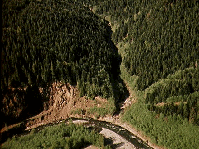
Figure 9.13 5100 Washout, viewed from south looking north
9.9 5601 Connector to 5103
Starting Point: West end of 5601 from Herrington Flats.
Ending Point: End of spur road at 5103, spotted owl survey point.
Status: Preliminary stake line, orange stakes with flagging for intervisibility. Traverse and design data exists for this road. Proposed for construction.
Stake # and Comments:
12 Sandy wash between alder clumps. Extremely loose soil at this point.
22 Stream crossing. Small channel type 4 or 5. Begin climbing hill away from old road grade at this point.
47 Stream crossing. High slope in channel, type 4 or 5. Relatively large fill at this crossing.
60 Stream crossing. High slope in channel, type 4 or 5.
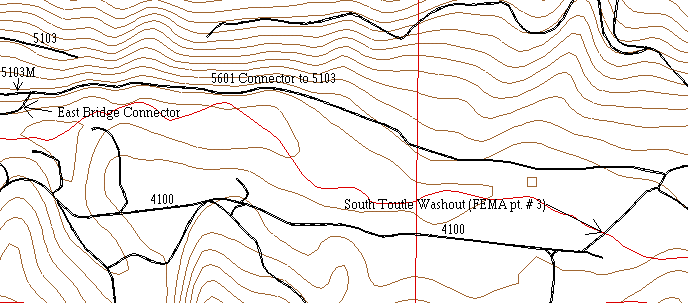
73 On grade with old skid road in cedar shake unit. Tie in to East connector.
75-77 On end of spur road to 5103 with owl survey point.
Comments: Although this road parallels the old 5601 road grade for a substantial distance, the location was chosen to prevent large future washouts. The old grade is located on a flat that is currently being undercut by the South fork of the Toutle.
Figure 9.14 Schematic of 5601 connector to 5103. Road also serves as the potential bridge east connector
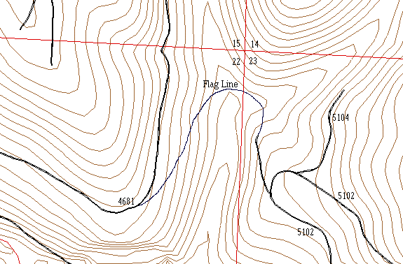
9.10 14 Creek Alternate Route, 4681 Connector to 5102
Starting Point: 33+00 east from 4680 & 4681 jct.
Ending Point: 10+00 east and then south, along the road, from 4104 & 4102 jct.
Status: Reconnaissance ribbon flag line (orange line for grade)
Soils: Saturated, unstable
Station and Comments:
0+00 Descending @ -12% to 12+50
9+00 - 11+00 Wet soil @ 40 % to 50% side slopes. Seepage and potential slumps and side cast failures.
11+50 Small stream.
12+50 - 13+50 Grade change from -12% to 0 %
17+00 Small stream
18+00 Potential bridge crossing. Bridge span is 55 ft. The tangent across the stream is at 38 degrees Az. The east side bridge easement starts into an 80 ft radius curve. The curve has 50 ft. chord lengths with a 36 degree deflection angle on all chords except the first and the last, which have deflections of 18 and 16 degrees respectively. To recapitulate, the tangent across the stream is at 38 degrees Az. The first deflection is 18 degrees from a 38 degree tangent giving a 56 degree Az. The second deflection is 36 degrees from 56 degrees giving a 92 degree Az. The third deflection is 36 degrees from 92 degrees giving a 128 degree Az. The fourth deflection is 36 degrees from 128 degrees giving a 164 degree Az. The fifth deflection is 16 degrees from 164 degrees giving a 180 degree Az. The fifth deflection crosses the east fork at a 50 ft. tangent. There was no grade carried across the curve.
20+50 East fork, north bridge easement, end curve, begin 150 ft tangent.
21+00 East fork, south bridge easement.
22+00 Begin ascending at 12% to meet 5102 at
36+00.
Station and Comments (cont.):
24+00 - 34+00 75% to 95% side slopes. Fern, devils club, and vine maple indicate poor soil conditions. Seeps and poor drainage saturate the soil. Great potential for slumps and side cast failure. Full bench and endhaul over ten stations would make this a costly option. These stations are very unstable. These stations are also the main factor in the decision to forego analysis on this option.
34+00 - 36+00 Flat, convenient road building.
36+00 Connection to 5102 spur.
Comments: The east face of the 14 creek connector is the problem area of this option. There were 75% to 95% side slopes. Fern, devils club, and vine maple indicate poor soil conditions on these side slopes. Seeps and poor drainage saturate the soil. There is a great potential for slumps and side cast failure. Full bench and endhaul from 24+00 - 34+00 would make this a costly option. These stations are the main factor in the decision to forego analysis on this option.
Figure 9.15 Schematic of 14 Creek Alternate Route, 4681 connector to 5102
See also Figure 9.13 for an aerial view of the 14 Creek Washout.
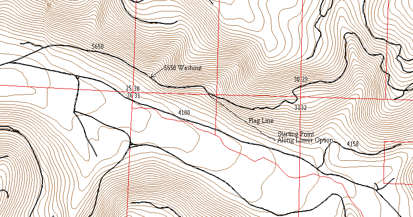
9.11 4100 Connector to 5650
Starting Point: 14+80 west along yellow option (lower road option).
Ending Point: First draw east of the washout on the 5650 (2000 ft east of the washout)
Status: Reconnaissance ribbon flag line (orange line for grade)
Station and Comments:
0+00 Begin grade ascension at 10% to 28+00
10+00 - 28+00 Rock cliffs and slides. Side slopes ranging from 75% to 100 %. Difficult road building. 18 stations of full bench and endhaul. Approximately 50 ft. of drill and shoot.
Comments: The difficulties that would be encountered with the road building made this option for the 4100 bypass of FEMA points 7 - 13 unfeasible.
Figure 9.16 Schematic of 4100 connector to 5650 starting from 14+80 along the lower 4100 alt.
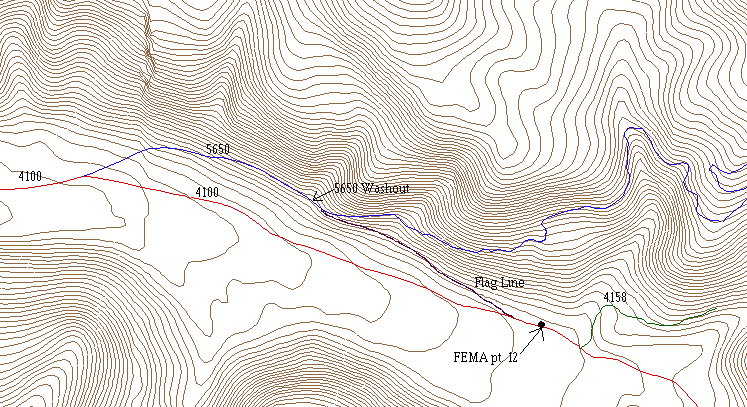
9.12 5650 to 4100 Connector
Starting Point: 400 ft. east of 5650 washout
Ending Point: 200 ft. west of FEMA pt. 12
Status: Reconnaissance ribbon flag line (pink line for grade)
Station and Comments:
0+00 Begin grade line at 5650 with grade of -10%
2+50 Rock cliff. 0% grade for 150 ft.
4+00 Resume grade at -10%
8+00 Stream crossing
16+00 Beginning of rock slides
20+00 Mass wasting area
24+00 Change grade to 0%, follow edge of hill
40+00 Connection with 4100
Comments: Between stations 0+00 and 24+00 side slopes range from 60 to 100%. Rock slides likely would result in costly maintenance in the future if a road was located
Figure 9.17 Schematic of 5650 connector to 4100