Chapter 7 Haul Time Comparison and Break-Even Analysis
7.1 Introduction
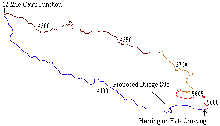
The main objective of this analysis is to evaluate the trade offs of either redesigning the 4100 and adding a new bridge across the South Fork Toutle River or choosing another option that would eliminate the need for a new bridge location. This analysis will be accomplished by comparing the haul times of the two options, and costing out the difference in the two haul times to come up with a minimum number of trips that must be made across the redesigned 4100 in order to pay for the addition of the bridge, as well as the additional road construction. The following figure displays the two routes that are to be analyzed. The redesign of the 4100 begins at the junction of the existing 4100 and the 5600. It then follows the abandoned 5601 road to its end, and then continues west until it reaches the proposed bridge site. At this point it continues south until it connects with the existing 4100 close to the junction of the existing 4100 and the 4100A spur, and then continues west along the existing 4100.
Figure 7.1 Schematic of redesigned 4100 option including the proposed bridge site, and the ridge option that follows the 5600-5605-2730-4250-4200.
The other option that is to be considered also begins at the junction of the 4100 and the 5600. From this point it follows the 5600 north until it reaches the 5605, at which time the route follows the 5605 to the 2730, and then it follows the 2730 to the 4250. From this point, the route follows the 4250 to the 4200, and finally it follows the 4200 out to the junction with the existing 4100. To acquire the necessary data to perform the haul time calculations, a GPS (Global Positioning System) was used to log data at positions of change in vertical and horizontal alignment. Utilizing a GPS was preferred over using ARC/INFO data, because the ARC/INFO road data that we had did not contain the appropriate grade and curve data that is necessary for use in haul time calculations. Once we obtained the necessary road data, the computer-based OTTO 2.0 truck performance model1 was used to calculate the haul times for each round trip. These results were then put into a spreadsheet, and the savings in haul times due to redesigning the 4100 and adding a new bridge was evaluated.
7.2 GPS Data Collection
The Trimble Pathfinder GPS was used along with a CMT (Corvallis Microtechnology, Inc.) MC-V datalogger to acquire data to be used in haul time calculations. GPS is a navigation system developed by the U.S. Department of Defense that uses between 4 and 8 of the 24 GPS satellites that orbit the earth, and computers to compute positions anywhere on the earth. A GPS was used for data acquisition because extensive amounts of roads could be traversed in less time than if they were traversed by hand, and the data was in the form that could be promptly downloaded onto a computer and ready for use.
To begin the data acquisition, the GPS unit was positioned inside of a vehicle with the antennae attached to the top of the vehicle. At this point the vehicle was stopped at either points of curvature, or points where there was a change in grade, and data was logged. A minimum of 30 points was taken at each location to ensure adequate accuracy. The GPS unit was set to log 1 point per second, resulting in a theoretical time of about 30 seconds per position (excluding travel time between positions). But due to obstructions such as hills or canopy cover, adequate satellite coverage was sometimes hard to come by. The result was an average of about 1.25 minutes per position (including travel time between positions). Positions were taken approximately 130 ft. apart, resulting in approximately 8.2 miles of road that could be GPSed in a seven hour period. With the acquisition of data complete, the next step was to make the necessary data corrections.
7.3 GPS Data Conversion
Before any of the data acquired could be used for analysis purposes, it had to be corrected for selective Availability. Selective Availability is an artificial degradation of the satellite signal by the Department of Defense that can be corrected by a process know as differential correction. This correction process was accomplished using the Trimble software package Pathfinder OfficeÔ . In order to complete this process, data that was taken at the same time as the uncorrected data must be obtained from a location of known coordinates, known as a base station. To correct our data, we acquired data from the USFS GPS Page (http://www.fs.fed.us/database/gps/portland.html) on the internet that was taken from their Portland, OR base station. Once we had the required data sets, the DIFFERENTIAL CORRECTION function was run within Pathfinder OfficeÔ to acquire the spatially correct points.
The next step in the preparation for haul time computation was to combine data and export it for use in OTTO. First, since some data for the same road was in multiple files, these files needed to be combined. Again this was accomplished within Pathfinder OfficeÔ by using the COMBINE command. Once the correct files were combined we exported them for use in OTTO. This was done within Pathfinder OfficeÔ using the EXPORT function. To accomplish this we customized the export format to an ASCII format that included the x and y coordinates in latitude/longitude, the elevation in meters, and attached a .gps extension to the export file. Figure 7.2 demonstrates the format that the GPS data must be in before it can be used in OTTO.
x-coordinate y-coordinate elevation
deg min sec deg min sec meters
46 14 21.24 122 26 16.70 352.5
Figure 7.2 ASCII export format of GPS data for use within OTTO
Now, the road data must be imported into OTTO. To accomplish this, the ROAD icon must be selected within OTTO. Next, the GPS icon must be selected, and the road file name, as well as the associated surfacing type and speed limit must be entered. At this time, the elevations will need to be corrected in order for OTTO to work correctly.
Although the obtained data are spatially correct for the x and y axes, an exaggeration was introduced in the vertical direction due to the satellite coverage. In order to correct this exaggeration we used the EXPONENTIAL SMOOTHING function within Microsoft Excel spreadsheet. This function can be found under the Tools/Data Analysis dropdown menu. Basically, this function detects trends in the data to predict values given a damping factor, and data interval. Before this function was used, all grades that exceeded 100% were minimized by a factor of 100 to eliminate the large spikes that would occur in the graph of grade versus distance. The function was then performed on the grade alone, and a damping factor of between .8 and .95 was used. The damping factor was adjusted until the resulting elevations at the beginning and the end of the road segment matched the elevations of the corresponding points obtained from the GPS. Figure 7.3 shows the result of this process as it was applied to the 2730 option. As the graph indicates, these results agree reasonably well with the actual gradient of this option. For example, the
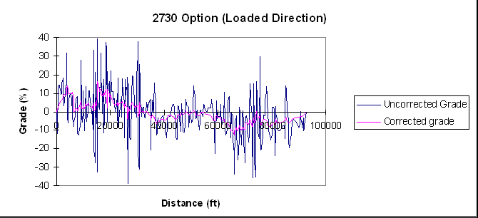
Figure 7.3 Before and After example of the grade of the 2730 option corrected for vertical exaggeration
grade quickly rises to about +15% for the first 5,000 ft., which corresponds to the 5600 portion of the road, from the Herrington Flats Crossing to the 5605 junction. Between 5,000 ft. and approximately 37,000 ft. the grade is predominantly positive, and lies between -4% and +16%. This corresponds to the 5605 and 2730 portion of the road. From approximately 37,000 ft. to the end of the road is predominantly negative grades that range from level to about -12%. This portion corresponds to the 4250 and 4200 portion of the road.
7.4 OTTO Truck Performance Model
OTTO is a truck performance model used to compute haul times for roads based on motor, transmission, truck configuration, driving technique, and road characteristics.
GPS files were directly imported into OTTO in the format discussed in the previous section. Once this data was imported it was ready for the analysis. All that is left is to determine the motor, transmission, truck configuration, and driving technique to be used in the analysis. The following tables display the configurations used for our analysis.
Table 7.1 Configuration of the truck motor used in OTTO.
Cummins NTC-400
Power(max) = 400bhp @ 2100 RPM
Torque(max) = 1320 lb-ft @ 1300 RPM
RPM idle @ 780 RPM
RPM range 1200 - 2100 RPM
Power
|
RPM |
Power (bhp) |
Fuel Consumption (lb/bhp-hour) |
|
1200 |
295 |
.33 |
|
1300 |
325 |
.32 |
|
1400 |
343 |
.32 |
|
1500 |
360 |
.32 |
|
1600 |
370 |
.32 |
|
1700 |
382 |
.33 |
|
1800 |
389 |
.33 |
|
1900 |
394 |
.33 |
|
2000 |
399 |
.34 |
|
2100 |
400 |
.35 |
Table 7.2 Configuration of truck transmission used for analysis in OTTO
Fuller RTO14610
Maximum input torque = 1450 lb-ft
Number of gears = 10
Gear Ratios
|
Gear Number |
Ratio |
Gear Number |
Ratio |
|
1 |
7.73 |
6 |
2.19 |
|
2 |
6.00 |
7 |
1.68 |
|
3 |
4.63 |
8 |
1.30 |
|
4 |
3.57 |
9 |
1.00 |
|
5 |
2.81 |
10 |
0.79 |
Table 7.3 Configuration of driver technique used for analysis in OTTO
|
Shifting technique |
Progressive |
|
Deceleration |
Medium |
|
Acceleration |
Slow |
|
Normal RPM Range |
50-60% RPM max |
|
Curve Speed |
Low |
|
Road Speed |
Medium |
|
Gear shifting rapidity |
Slow |
Table 7.4 Truck configuration used for analysis in OTTO
Tractor Width = 8.2 ft.
Tractor Wheel Base = 20.0 ft.
Fifth Wheel to Rear Trailer Axle = 30.7 ft.
Truck Weights
|
Front Axle |
Rear Dual Axle |
Trailer Axle |
|
|
Empty 28,000 lb |
10,000 lb |
18,000 lb |
0 |
|
Loaded 78,000 lb |
10,000 lb |
34,000 lb |
34,000 lb |
7.5 Results of Haul Time Analysis
Each road option was run within OTTO using 2 separate conditions: a rough gravel surfaced road, and a selected gravel surfaced road. Although using rough gravel surfacing material is not a practical option considering that this road is a replacement for a mainline, it has been provided for comparative purposes. Table 7.5 displays the haul times for the two options that are being analyzed with respect to the surfacing type. Data
Table 7.5 Haul times for the 2730 option and the redesigned 4100 option with respect to surfacing type
|
Road Option |
Condition |
Loaded Haul Time (min.) |
Empty Haul Time (min.) |
Round Trip Time (min.) |
|
2730 |
||||
|
5600-5605-2730- |
Rough Gravel |
49.75 |
45.75 |
95.5 |
|
4250-4200-4100 |
Selected gravel |
43.74 |
40.49 |
84.23 |
|
4100 |
||||
|
Redesigned |
Rough Gravel |
35.27 |
34.82 |
70.09 |
|
Mainline |
Selected gravel |
27.78 |
27.13 |
54.91 |
was available on the 4100 along the existing road from the Herrington Flats Crossing to the 12 Mile Camp junction, but not available for the redesigned portion from the Herrington Flats Crossing to the proposed bridge site. To compensate for this fact an additional 60 seconds was added to the loaded time and 45 seconds was added to the empty time. Not having this data should not affect our analyses, because the difference in distance between the existing portion of the 4100 and the redesigned portion is relatively small (approximately 4,000 ft.), and also this portion of the road is short in comparison to the overall road length.
As Table 7.6 shows, the difference in haul times comes from the fact that the 2730 option is 19,600 ft. (3.7 miles) longer than the 4100, and the average speed over the entire 2730 option is 5.8 mph and 5.9 mph slower in the loaded and empty directions respectively. The slower speeds along the 2730 option are due to the poor horizontal alignment (Figure 7.1), as well as the steep, adverse grades present in the 5600,5605, and 2730 segments of
Table 7.6 Speeds and distances for the 2730 and the 4100 option
|
Loaded |
Speed |
(mph) |
||||
|
Road Option |
Road Segment |
Distance (ft) |
Speed Limit |
Max. |
Min. |
Average |
|
2730 |
5600-5605-2730 |
31372 |
25 |
25 |
7.92 |
15.9 |
|
4250-4200-4100 |
61330 |
30 |
30 |
17.43 |
28.3
|
|
|
Total Road |
92702 |
24.1 |
||||
|
4100 |
4100 |
73143 |
35 |
35 |
12.5 |
29.9 |
|
Empty |
Speed |
(mph) |
||||
|
Road Option |
Road Segment |
Distance (ft) |
Speed Limit |
Max. |
Min. |
Average |
|
2730 |
5600-5605-2730 |
31372 |
25 |
25 |
7.79 |
21.1 |
|
4250-4200-4100 |
61330 |
30 |
30 |
18.75 |
28.5 |
|
|
Total Road |
92702 |
26.0 |
||||
|
4100 |
4100 |
73143 |
35 |
35 |
12.5 |
31.9 |
the road option. Figure 7.4 shows the speed and grade graphed versus the distance along the road (in the loaded direction). From the graph of the 2730 option, it can be seen that the speeds are clearly lower at the points of increased grade that occur in the previously mentioned road segments. Truck speeds approached the set speed limit once the truck reached the 4250-4200 road because of better horizontal and vertical alignment. The graph of the 4100 shows that with the predominantly low grades, the speeds are consistently near the limit. Keep in mind that with the addition of the redesigned portion of the 4100, the grades for approximately the first 11,000 ft. of the road will be slightly higher and the speeds likely will be slightly lower through this portion.
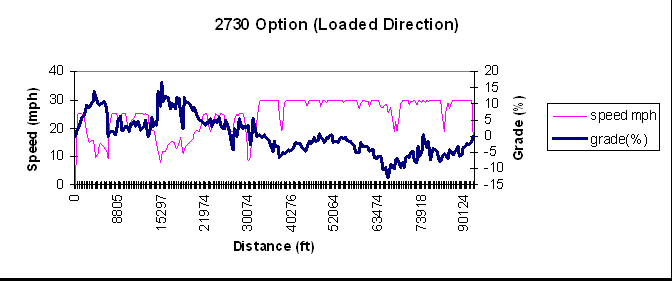
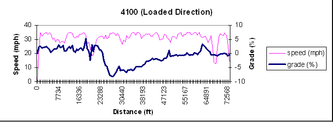
Figure 7.4 Graph of speed and grade versus distance in the loaded direction for the 2730 option and the existing 4100 from the Herrington Flats Crossing to the 12 Mile Camp Junction
7.6 Break-Even Analysis
The final analysis that has been done is a break even analysis between the two options. To achieve this, the round trip haul time had to be computed first. Then, the difference in the haul times was tabulated. Next, this difference was multiplied by a truck rate ($/hr) to achieve the amount of money that would be saved per round trip by redesigning the mainline instead of using the 2730 option. Since a specific rate was not known, the analysis was run for 3 separate rates: 45 $/hr, 55 $/hr, and 65 $/hr. Also, the cost difference between redesigning the mainline and using the 2730 option was computed. A value of $200,000 was used for this analysis. This value was based on a cost of $140,000 for the bridge, $150,000 for the east connector to the bridge, 25,000 for the connector from the bridge south to the 4100, and allowed for $110,000 in repairs on the 2730 option to bring it up to the desired standard for a main haul route. And finally, the cost difference between the 4100 and the 2730 option was divided by the amount saved per trip that was computed earlier. This achieved the amount of round trip hauls over the redesigned 4100 it would take to break even with the additional amount it would cost to redesign the 4100 and add a bridge, as opposed to using the 2730 option. Table 7.7 displays the break even analysis that was run on the two options.
Table 7.7 Break even analysis of 4100 versus 2730 option from the Herrington Flats Crossing to the 12 Mile Camp Junction.
|
Road Option |
Condition |
Round Trip Haul Time |
Number of Trips Needed To Break Even |
||
|
(min.) |
45 $/hr |
55 $/hr |
65 $/hr |
||
|
2730 |
|||||
|
5600-5605-2730- |
Rough gravel |
95.50 |
|||
|
4250-4200-4100 |
Selected gravel |
84.23 |
|||
|
4100 |
|||||
|
Existing |
Rough gravel |
70.09 |
10,493 |
8,585 |
7,265 |
|
Mainline |
Selected gravel |
54.91 |
9,095 |
7,441 |
6,296 |
7.7 Discussion
As the results from the previous section show, the amount of round trip hauls that it would take to break even with the added costs of redesigning the 4100 mainline widely varies with the truck rate used. Table 7.8 displays how many timber sales it will take to achieve the desired round trip hauls. A range of between 6,000 and 11,000 round trip hauls was used to reflect the range of truck rates that are likely to be incurred. In reference to Tables 7.7 and 7.8, for a low truck rate (45 $/hr) it would take approximately 9,000 trips across the redesigned 4100 to break even with the cost of the bridge and additional road construction, amounting to approximately 15 timber sales.
Table 7.8 Total volume of timber that will have to be hauled across the redesigned 4100 in order to break even with the additional cost incurred, as well as an estimation as to the time it will take to achieve this volume. Performed over a range of 6,000-10,000 round trip hauls
|
Number of |
Estimated |
|||||
|
Round Trip Hauls |
MBF/Trip |
Total MBF |
Avg. MBF/Sale |
Tot. # of Sales |
# of sales/ year |
# of years to break even |
|
6,000 |
5 |
30,000 |
3,000 |
10 |
2 |
5 |
|
7,000 |
5 |
35,000 |
3,000 |
11.7 |
2 |
5.8 |
|
8,000 |
5 |
40,000 |
3,000 |
13.3 |
2 |
6.7 |
|
9,000 |
5 |
45,000 |
3,000 |
15 |
2 |
7.5 |
|
10,000 |
5 |
50,000 |
3,000 |
16.7 |
2 |
8.3 |
|
11,000 |
5 |
55,000 |
3,000 |
18.3 |
2 |
9.2 |
The result is that it will take anywhere from 10 to 19 timber sales to break even on the additional cost that redesigning the 4100 will present. This would take approximately 5 to 9.2 years to accomplish, if we consider that 2 timber sales per year utilize this alternative. This result is reasonable when considering the expected life of a concrete bridge is at least 30 years.
SNAP indicates that it is economically feasible to build the bridge and its accompanying approaches within the first five year period. What this analysis has provided is a time frame in which the bridge would be paid for due to the savings in haul times between the current condition (2730 option), and the condition with the bridge and approaches in place.
7.8 References
1. Jalinier, C., and Nader, J. May, 1993. OTTO: Truck Performance Simulator Program, Forest Engineering Research Institute of Canada, Technical Note TN-195. 8 pg.