|
||||||||||||
|
|
Sites in the Tahirler Survey Region
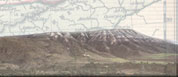
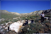
UykuThe site of Uyku lies north of the paved modern highway that connects Beypazari to Cayirhan. The site, covering an area of ca. 300 by 400 meters, spreads across a series of narrow stony terraces above a dry stream bed. On the lowest terrace [marked A on map #4]., we identified and photographed the remains of a monumental building with steps on its southern side. Located immediately above these steps are several enormous marble blocks (one possibly a lintel; another with architectural carving), presumably from the same ancient building. At the eastern end of this building are the remains of what appears to be a very large apse constructed with re-used marble blocks. Beneath this building there is a stream bed, dry in summer but probably subject to heavy flooding in winter. Above the eastern side of the stream bed, a robber hole has revealed the remains of a second monumental building composed of medium-size marble blocks, some them apparently still in situ. Humps under the ground suggest the presence of several further stone buildings located on the narrow terraces rising above terrace A. Aerial photography could probably confirm this hypothesis, but weather conditions (lack of wind) stymied our attempt to use a balloon for this purpose. The attached map is based upon readings taken from a electronic total station set atop the high flat ridge (Area B) that overlooks the lower terraces. Tahirler Project staff collected ceramics from across these terraces, using a combination of systematic walking (along transects that followed the contours of the terraces) and ‘random grab’ across the whole area. Due to the abundance of sherds in this area, only fine ware and indicators were collected. Initial analysis of this material suggests that there was Bronze and Iron age settlement on top of the ridge (Area B), while the lower terraces were occupied primarily during the Roman and Byzantine periods. Finds of early-mid Roman fine ware were concentrated around area A. Other finds confirmed that settlement at the site continued down to the end of the Byzantine period. We found one coin, later identified as a fairly common eleventh-century Seljuk denomination. And in an emergency excavation approved by the Department of Antiquities, we excavated a Middle Byzantine vat, which had been exposed by erosion along the eastern bank of the stream bed marked on the map as area C. This Byzantine ceramic vat has since been reconstructed and is now on display in the garden of the Museum of Ancient Anatolian Civilizations in Ankara. Although our research on Uyku is still at a preliminary stage, we have developed the following hypotheses about the site. The monumental building at Uyku was probably a Roman temple, with its earliest phases of construction during the early-mid Roman period. From the Roman highway approximately four kilometers south of Uyku, one has a clear line of sight up the narrow, flat valley that leads north towards Uyku: a monumental building on terrace A would thus have been visible to travelers along the Roman highway between Juliopolis and Lagania. It is our theory, therefore, that the ruins at Uyku represent a rural Roman shrine, with a series of modest ‘service’ buildings surrounding a central monumental temple. The apse at the eastern end of this temple suggests that its building was converted into a church at some stage during the early Byzantine period. Settlement at the site continued until at least the eleventh-twelve centuries, when growth of the new Seljuk city at Beypazari may have diverted attention from Uyku. We hope to continue analysis of the ceramics from Uyku during the museum study season in September 2002. |
|||||||||||