Global Patterns of New Zealand
Mount Cook is a precious gift of nature that stands tall over the islands of New Zealand in the heart of the Southern Alps. The Southern Alps stunning landscape and unique blend of temperate rainforests and glacial mountains make the area one of a kind. Mount Cook's elevation of 12, 314 feet and position with regards to the South Pole are contributing factors to its great amount of snow and glaciers yet, as you move down the glacial faces you will run into rainforests.
Mt. Cook is one mountain of more than 140 that make up the Southern Alps which guard the eastern plains of the south island. The Southern Alps and Mt. Cook parallel a similar pattern to the Northwest corner of the United States, specifically Mt. Rainier and the cascades. Mt. Rainier has a slightly higher elevation at 14, 410.1 feet and is surrounded by several glaciers however; many of Rainier's glaciers have melted while most of Mt. Cook's glaciers are advancing. The United States Geological Survey recently stated that Mt. Cook's glaciers are slowing their retreat or approaching a steady state and several are advancing (2000). The Franz Joseph Glacier is advancing at a phenomenal rate of 70 cm a day (Wikipedia 2007). Although the glacier is growing at a pace of 10 times that of other glaciers, it has recessed since the last ice age. This cyclic behavior can be described by the view from St James Anglican Church. The church was built in 1931, with a panoramic altar window to take advantage of its location to the glacier. Beginning in 1954, the glacier disappeared from view from the church for over 40 years until it reappeared in 1997 (Wikipedia 2007).
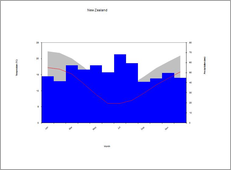
This Climate graph represents the mean temperature and precipitation throughout a calendar year. As you can see, Christchurch, New Zealand (where these numbers were recorded) experiences the most dry temperatures in July and August. As for precipitation, December, January and February are the most active months of the year.
(World Weather 2007)
Lake Pukaki is just one of the three large lakes on the Southern Island in New Zealand. It is fed from the Northern point of the lake from the large Tasman and Hooker Glaciers on Mt. Cook. With the use of hydroelectric dams on the Tasman River that feeds into Lake Pukaki, it provides nearly half of islands hydroelectric capacity (Wikipedia 2007). The lake was formed by the receding of the glaciers and their terminal moraine, which explains the basin of the lake made out of glacial flour. The glacial flour in the lake gives it the very vibrant deep blue color. The northwest coast of North America also shares the same climate as New Zealand and the Southern Alps. According to the Koppen Climate System,
One thing that is unique to
There is nowhere else in the world where glaciers come so close to the coast line while being outside of the polar regions. This not only makes the glaciers very accessible but much warmer with respect to other glacial sites in the world. The glaciers are able to survive because of the high elevation, topography, and location with respect to the South Pole. These factors help produce great snow fields which feed the multiple glaciers around the mountain. However, recent climate changes are threatening the glaciers at
Last modified: 6/09/2007 3:55 PM