The Cretaceous Chalk
in Southern England
By Brieanna Graham
During the
Cretaceous Period chalk deposits built up over most of the planet (Wicander 2004). This was a result of almost the entire
planet experiencing the same environmental conditions. The earth was going
through a warming period following the Permian, and it reached a climax at the
end of the Mesozoic, the Cretaceous (Wicander 2004).
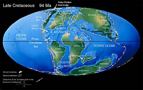
This environment was characterized by warm, shallow seas covering most of the
continents and no ice caps (Wicander 2004). The image
below shows the location of the landmasses in the Late Cretaceous and sea level
at that time (Scotese 2003).
On a worldwide
scale sea level had risen 600 meters and “many continental areas, which had
been land since the Paleozoic, were flooded by shallow water” (Oxford Museum 8
Aug 2006). Because of this warm environment a thick layer of chalk formed in
most of the world’s oceans and can now be seen in places such as France,
Scotland, Greenland,
Asia, and Texas
(Rayner 1967). Along the Jurassic Coast of Southern England the chalk is
“synonymous with the Upper Cretaceous beds” (Bennison
1969). It can be seen at various points along the Jurassic
Coast and is the youngest rocks
found in this World Heritage Site (Gallois 1995). A
long and complex story is associated with the chalk.
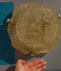
Chalk
is “made up of whole or broken coccoliths…up to
10μm in diameter” (Melville 1982). Four hundred million coccoliths would be necessary to cover a single £1 coin (Gallois 1995). Below is a model of a coccolith
enlarged 10,000 times in the Museum
of Natural History.
More specifically, “coccolithophores are small, single-celled autotrophs covered with disks of calcium carbonate (coccoliths) fixed to the outside of their cell walls”
(Garrison 2002). These tend to live near the surface of the ocean in areas
where there is an abundance of sunlight (Garrison 2002). Coccolithophores
can become so abundant that they will give the water a milky or chalky
appearance (Garrison 2002). In warm water coccoliths bloom
and in clear, undisturbed water their skeletons can sink to the ocean floor and
be preserved to form chalk (Brundsen 2003). Coccolith shells form a matrix in which other calcium
components are often trapped and subsequently embedded into the chalk (Melville
1982). The coccoliths in Southern England “are present
in vast numbers and in all stages of disintegration down to individual
component crystals” (Chatwin 1960). In this area many other calcium
carbonate remains are found, including, “calcispheres
(Oligostegina),
formanifera, and fragmentary debris of many larger
invertebrates (especially the bivalve Inoceramus)” (Melville 1982).
The chalk in Southern
England is considered a calcareous ooze, which is an “ooze
composed mostly of the hard remains of organisms containing calcium carbonate”
(Garrison 2002). The accumulation of ooze on the sea floor depends on “a
delicate balance between the abundance of organisms at the surface, the rate at
which they dissolve once they reach the bottom, and the rate of accumulation of
terrigenous sediment” (Garrison 2002). Oozes
accumulate very slowly, at a rate of only about 1 to 6 centimeters per thousand
years (Garrison 2002) but the deposition of the chalk in Dorset took place 100
million years ago until the end of the cretaceous 65 million years ago (Gallois 1995) so it had a long time to build up over 410
meters of chalk (Rayner 1967).
The
environment that the chalk formed in was significant to how and why it formed
as it did in Southern England. The chalk layer
“indicates the most considerable change in conditions in Purbeck times, namely,
an invasion of the sea which spread over a large part of the south of England”
(Melville 1982). At the beginning of the Mesozoic the supercontinent
Pangaea began rifting apart and drifting to its present day locations (Wicander 2004). By the Cretaceous Period “America
continued to drift away from Europe” and the “Atlantic
Ocean and Mediterranean expanded” resulting
in the entire area being drowned in a warm, shallow, extensive sea (Brunsden
2003). Most of Britain
was under water and “evidence of shorelines [was] scanty even in the western
outcrops” and near Scotland
(Bennison 1969). Throughout the Cretaceous “shallower
water conditions became established at times but there is no evidence that any
area became emergent” (Bennison 1969). Bioturbation and nodular beds are often used as evidence to
show that the water was shallower at times (Bennison
1969) as well as ripples, or current action (Chatwin 1960). “Marls indicate an
increase in terrigenous material possibly consequent
on the elevation of neighboring land areas” (Bennison
1969). The environment in which the chalk was deposited was not consistent;
there is evidence of cyclic deposition “with episodes of low energy and steady
accumulation alternating with ones of higher energy and perhaps shallower
water, when deposition was interrupted” (Melville 1982).
The
climate was much warmer when the chalk formed than it is now. We know that the
water was warm because of the composition of the rock. The billions of cocolithophores which made up the chalk only survive in
warm, relatively pure water, so this sea must have had these conditions (Gallois 1995). Calcareous oozes can only form in water less
than 4500 meters in depth, so the chalk was not formed in any sort of deep sea
environment (Garrison 2002). This chalk had to have
been deposited in water approximately 200 to 300 meters in depth because this
is the only way the small, delicate cocolithophores
would have been preserved (Melville 1982). The chalk is thought to have formed
on the outer edge of a continental shelf, the biggest in any Jurassic sea found
along the Southern Coast of England (Melville 1982). At this point in time England
is thought to have been situated at “a more southerly location…than at present”
which would have augmented the already higher temperatures (Lovell 1977).
The Chalk
Sea lasted for approximately 30
million years (Ensom 1998) which was enough time for billions of coccolithophores shells to be deposited on the seafloor (Gallois 1995). One thing that makes the chalk so unique is
the near “absence of terrigenous material” (Chatwin
1960). This is due to the fact that land was a great distance away from the
depositional environment (Chatwin 1960). Also, the land had to have been fairly
flat and would not have had a good mechanism with which to bring detrital matter out to the open sea (Rayner 1967). The
chalk is especially unique because it has the greatest outcrop area of any
formation in England
(Rayner 1967).
Within
the chalk there are three subdivisions, the Lower Chalk, the Middle Chalk, and
the Upper Chalk. The contacts between these layers are gradational, indicating
a gradual change in environment (Wright 1981). The layers of chalk can be
identified by their lithological characteristics, as
well as the fossils they contain (Chatwin 1960). Over time, the water in the
area became deeper and the chalk became purer (Gallois
1995). Only the Upper Chalk has many economic uses, “it writes readily on wood,
and is fit for the cooper, for whiting, for lime, and for manure” (Wright
1981). The Middle Chalk is noted as only being fit to use on highways (Wright
1981). Overall however, the chalk is hard enough to be a significant building
tool but only on the local level because it is so much softer than the
surrounding limestone (Ensom 1998).
The
Lower Chalk is situated directly above the Glauconitic Marl and is mostly
composed of Chalk Marl and Grey Chalk (Melville 1982). The lowest portion of
the Lower Chalk, called the Varians Zone, begins with “the glauconitic ‘Chloritic’ marl, sandy and nodular, which grades up into
grey marly Chalk” (Bennison
1969). The sponge Exanthesis labrosus is
very common in the Varians
Zone in the Isle of Wight (Melville 1982). The Lower
Chalk as a whole is characterized by “ammonites of the genera Schloenbachia, Mantalliceras,
and Hypoturrilies,
bivalve shells including ‘Aequipecten’ beaveri, Entolium sp., Plicatula inflata and Inoceramus crippsi, and tubes of the worm ‘Serpula’ umbonata”
(Mellville 1982). The Upper Part of the Lower Chalk
is characterized by the belemnite Actinocamax plenus and ends at the Plenus
Marls where it then gives way to the Middle Chalk (Melville 1982).
The
Middle Chalk varies in thickness by up to 60 meters, but in most places it is
much less than that (Melville 1982). The base is very nodular and is “hard and
white in places and elsewhere containing slightly yellow nodules and lumps in
pale grey streaky marl” (Melville 1982). This basal bed is called the Melbourne
Rock (Bennison 1969), but is not recognizable in South
Dorset and the Isle of Wight (Melville
1982). Common fossils found in the Melbourne Rock include: brachiopods and the
echinoids as well as the bivalve Mytilides mytiloides (Melville 1982). The rest of the Middle
Chalk is mostly “white and homogenous, with marl partings” showing up
occasionally (Melville 1982). The Middle Chalk is usually without flints except
for the uppermost 30 feet (and in the Isle of Wight is
completely without flints)” (Bennison 1969). One
break in the homogeny is that in Swanage and the Isle
of Wight, “the upper part of the Middle Chalk becomes lumpy and
nodular” and is termed the ‘Spurious Chalk Rock’ (Melville 1982). The most
common fossils found in the Middle Chalk are brachiopod shells, echinoids and
bivalve shells (Melville 1982). In the upper part of the Middle Chalk the echinoid Holaster planus and Micraster sp. are
common, as well as the bivalve Inoceramus lamarcki (Melville
1982). Throughout the Middle Chalk actual ammonites are rare, but there is
evidence of their presence (Wright 1981). “Ammonite aptychi and impressions of ammonite shells [are found] on
the bases of corals, oysters and other originally calcitic
cemented forms” (Wright 1981).
The
Upper Chalk is the largest portion of the entire chalk beds (Melville 1982). It
is up to 404 m in the Isle of Wight and 260 m in Dorset
(Melville 1982). It is described as “milk-white, fine in its grain and smooth
when cut” (Wright 1981). The base of the Upper Chalk is marked by the hardest
layer of all, the Chalk Rock (Melville 1982). It has a nodular character and
was deposited in unusually shallow water (Bennison
1969). It contains the fossils of sponges and the moulds of ammonites and
gastropods (Melville 1982). Above the Chalk Rock the chalk becomes very smooth,
white, and “massively bedded, except for nodular beds and hardgrounds
in…the pilula
Zone of the Isle of Wight and Dorset” (Melville 1982). There are many different
types of fossils present in the Upper Chalk (Bennison
1969). These include remains of fishes, in particular
teeth are quite common, as well as the remains of sharks and teeth of ray
fishes (Melville 1982). This provides extra evidence to support the statement
about how calm the water was in which the chalk was found. Sharks have a
cartilaginous skeleton, and are usually not preserved well since they are so fragile
(Wicander 2004). To find a shark skeleton means that
the water was not disturbed much over a long period of time. Echinoids such as Micraster and Echinocorys are common and can be used to correlate
different layers of chalk (Melville 1982). Ammonites are also used for
correlation including the Hyphantoceras reussianum (Bennison 1969).
Other fossils present include: gastropods, bivalves, oysters, brachiopods, and
sponges which are commonly enclosed in flint (Melville 1982).
An
important characteristic of the chalk is the formation of chert. Chert is a
dense, smooth rock made up of silica (Chesterman
2005). It forms when “certain algae and protozoans,
which, having accumulated on the ocean bottom [are] compacted and partly recrystallized to form chert of opaline
composition” (Chesterman 2005). Other cherts form when silica is precipitated out of sea water
and condenses into rock (Chesterman 2005). The chert
can be found within the chalk. As the chalk breaks apart
nodules or layers of chert are exposed (Davies-Vollum
28 Jul 2006). Along the Jurassic
Coast the chert is typically yellow
colored though it can also be various other colors (Chesterman
2005). The chert is very hard and fractures conchoidaly,
like glass (Chesterman 2005). A certain specific kind
of chert was especially common along the Jurassic
Coast, flint (Davies-Vollum 28 Jul 2006).
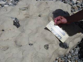
Flints
are common along certain areas of the Jurassic
Coast where the chalk outcrops.
Below is a picture of flint embedded in the chalk at Lulworth Cove.
For a long time the boundaries
between the Lower, Middle, and Upper Chalk were determined by the abundance of
flints before they were adjusted to where they are now (Wright 1981). The Upper
Chalk contains an abundance of flints, while the Lower Chalk completely lacks
flints (Bennison 1969). Flints
are “a fine grained form of quartz, formed during the early
stages of hardening of the chalk sediment” (Gallois
1995). Flint generally forms near
the surface of the earth in a low pressure, low temperature environment (Chesterman 2005). It contains no crystals and has a
hardness of 7 on a scale of 1 to 10, with 10 being the hardest substance on
earth (Chesterman 2005). Flint
is commonly found on the surface of the chalk because as the softer chalk
erodes away the hard flint pieces are left on top (Oxford Museum 8 Aug 2006). “Flint
formed at several different periods during and after the deposition of the
Chalk” (Melville 1982). Flint
filled in burrow holes in the chalk, allowing these to be preserved in areas
that the burrow holes normally would be indistinct (Melville 1982). “At a later
stage these may have been joined together by further growth of flint to form
more or less continuous courses of nodules” which had to have formed prior to
the Tertiary deposits since the flint often shows up as pebbles in Tertiary
gravels (Melville 1982). Within the flints fossils of “shells of sea urchins,
bivalves and sponges” are common (Gallois 1995). Flints
are a “major source of aggregate for the construction industry” (Ensom 1998)
and ideal for the manufacture of stone tools due to their composition and
durability (Gallois 1995). In the town of Beer
flint has been used as a local building tool due to its durability and
availability (Brunsden 2003). However, there is a great deal of controversy
about whether or not it would be wise to remove these flints because they are
actually very good at preventing erosion of the chalk cliffs (Ensom 1998). Up
until the 1970’s the flint was mined until “growing fears concerning depletion
of the beaches led to a ban being imposed” (Ensom 1998).
The
chalk outcrops in several places along the Jurassic
Coast including Beer, Axmouth to Lyme Regis, White Nothe, Lulworth Cove, and Old Harry Rocks (Brunsden
2003). Old Harry Rocks are located on
the eastern edge of the Jurassic Coast
and Beer is located on the western end of the Jurassic
Coast (Brunsden 2003).
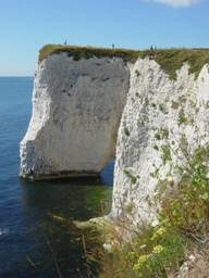
Old Harry Rocks is
a massive Upper Chalk formation near Sawnage
(Brunsden 2003). At Old Harry Rocks the chalk has been eroded extensively.
Waves will find weaknesses in the rocks and will erode these areas until they
form arches or caves. These then continue to erode until the arch collapses and
there becomes a tall island of chalk called a stack. Finally, the chalk stack
or needle (a stack that comes to a point) will be eroded to the point that they
collapse completely (Brunsden 2003). As
recently as a few thousand years ago the area around Old Harry Rocks was
connected to the Isle of Wight, but they are now
separated by the English Channel (Brunsden 2003). As of
1770, a person could climb out to Old Harry Rocks which are now considered to
be a stack of rock not connected to the rest of the chalk (West 2006). In 1896,
the Wife of Old Harry, another chalk stack, collapsed (West 2006). However, it is
important to note that while some of the chalk formations are collapsing,
others are constantly being created as the waves continue to erode weaknesses
in the rock (West 2006). Eventually the small arch in the rocks on the left
will look like the rocks on the right.
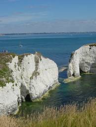
Clearly, these land forms are in a
constant state of erosion and change. At the site of Old Harry Rocks the chalk
is nearly horizontal, only dipping at 8° North (West 2006). Several small
faults and joints can be seen in this area but they are not big enough to
indicate any sort of major tectonic activity (West 2006).
There
is some major faulting within the chalk, though not seen at Old Harry Rocks. At
Ballard Point the chalk is curved to a near-vertical orientation and this can
be viewed by boat from the English Channel (West 2006).
The chalk above the faulting is from the Upper Chalk and is 76 meters thick (West 2006). Image from
West 2006.
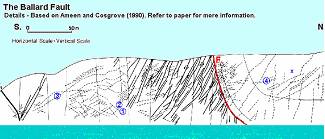
The thrust fault was caused by compression and probably originated from
tectonic movements related to the uplift of the Alps (West 2006). The current structure
of the Jurassic Coast
has not been altered much since this event (Melville 1982).
Another major geologic
feature along the Jurassic
Coast where the chalk can be seen is Lulworth
Cove. Here the Lower and parts of the Middle Chalk make up the resistant back
wall to the bay (Burnsden 2003). Lulworth Cove was
formed when a stream first breached the resistant Portland Limestone (Brunsden
2003). This allowed sea water to wash back into the stream and consequentially
the weaker Wealdon Beds located behind the Portland
Limestone began to erode (Brunsden 2003).
As the Wealdon Beds were eroded more and more
the area began to take on the shape of a cove until it finally reached the more
resistant chalk beds which greatly slowed the spread of the cove to the north
(Brunsden 2003). The chalk found at Lulworth Cove has been greatly altered by
tectonic activity. The chalk was deposited in the Lulworth Cove area 90 million
years ago (Gallois 1995). However, 30 million years
ago the entire area was compressed due to Alpine Earth Movements (Gallois 1995) and now parts of the chalk have been
completely overturned (West 2006).
The chalk can be seen
along the Jurassic
Coast at the site of the great unconformity which
can be viewed at Branscombe and Golden Cap (Brunsden
2003). The unconformity represents a time gap between rock ages, implying there
was deposition of rocks, and then erosion so a great portion of the geologic
record is lost. Along the Jurassic Coast “The rocks were tilted east in the
Mid-Cretaceous, and then eroded by seas and rivers. There was little erosion in
the east of the [Jurassic Coast] Site but in the west, all the Jurassic and
Lower Cretaceous rocks are missing and the Upper Cretaceous rocks lie directly
on the eroded surface on the Triassic” (Brunsden 2003). In Seaton the white
chalk can be viewed right beside red Triassic rocks (Davies-Vollum
3 Aug 2006).
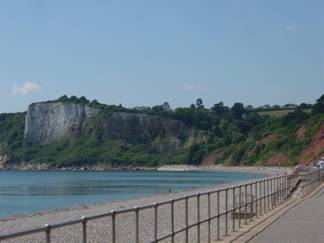
The chalk is very hard in this spot, and much more
splintery than at Old Harry Rocks. It is closer in composition to the
Beer Stone which is located below the chalk. In this spot the Triassic rocks
are very soft, red, and eroded. The fault has weakened the rocks joining the
two beds and consequentially there is a large V in the land between the chalk
and Triassic rocks (Davies-Vollum 3 Aug 2006).
The landscape in Southern England has been largely dominated by the chalk.
The Isle of Purbeck is considered to be an island because of the chalk. The
chalk has created a hard band of hills that can only be crossed in two
locations, by Corfe Castle and on Highway A351 (Davies-Vollum 28 Jul 2006). This makes the Isle of Purbeck an
island because it is as isolated as an island. Corfe Castle was strategically places in one of the dips
that was naturally cut by a river. This means that
anyone wanting to go into the Isle of Purbeck had to pass by Corfe Castle so it was an excellent place for trade and
consequentially dictation of the surrounding area (Davies-Vollum
29 Jul 2006). The chalk is also responsible for the topography of Lulworth
Cove, because its hard structure does not allow the cove to expand farther to
the north (Gallois 1995). In addition to the
topography, the chalk is responsible for some of the vegetation of the region. Because
it breaks down to form such poor soil only short turf can grow there, and
hardly any trees (Melville 1982). The area where this is most obvious is at
Lulworth Cove. Vegetation growing on top of the chalk is sparse and short. It
is easy to see where the chalk meets the Greensand because the vegetation
changes so dramatically from short grasses growing on the chalk to the more shrubby, lush vegetation on the Greensand.
The Cretaceous
ended in a catastrophic manner 66 million years ago (Wicander
2004). The Chalk Sea
retreated and the rocks were exposed to erosion and slight folding (Melville
1982). The cause of the enormous change in environment was the arrival of the
asteroid which hit earth and resulted in the second largest extinction in
earth’s history (Wicander 2004). The dinosaurs, giant
marine reptiles, and ammonites were all gone. An entirely different global
environment dawned; one dominated by mammals, flowering plants, and grasses,
like we have today (Brunsden 2003).
References Cited:
Bennison,
George M., Alan E. Wright. 1969. The
Geological History of the British
Isles. New York St. Martin’s Press. New York.
Brunsden, Denys
Ed. 2003. The Official Guide to the Jurassic Coast, Dorset and East Devon Coast World Heritage Site- A Walk Through Time. Coastal Publishing.
Wareham.
Chatwin, C.P., 1960. British Regional Geology The Hampshire Basin and Adjoining Areas 3rd Edition.
Her Majesty’s Stationary Office. London.
Chesterman,
Charles W. 2005. National
Audobon Society Field Guide to North American Rocks and Minerals. Alfred A. Knopf. New York.
Davies-Vollum, Sian. Lecture
28 Jul, 29 Jul, and 3 Aug 2006.
On site.
Ensom, Paul. 1998. Discover Dorset Geology.
Dovecote Press. Wimborne.
Gallois, Ramues. 1995. Holiday Guide:
Lulworth Cove Area. British Geological Survey. Exeter.
Garrison, Tom. 2002. Oceanography An
Invitation to Marine Science 4th Edition. Wadsworth Group. Pacific
Grove.
Lovell, J.P.B. 1977. The British Isles
through Geological Time A Northwest Drift. George Allen & Unwin Ltd. London.
Melville, R.V., Freshney,
E.C. 1982. British Regional Geology The Hampshire Basin and Adjoining
Areas 4th Edition. Her Majesty’s Stationery Office. London.
Oxford Museum.
8 Aug 2006. “Cretaceous Chalk” Second Floor, Display Case #13.
Rayner, Dorothy H. 1967. The Stratigraphy of the British Isles. Cambridge University Press. London.
Scotese, Christopher R. 2003.
Paleomap Project. <http://www.scotese.com/cretaceo.htm>.
West, Ian. 2005. “Lulworth Cove—Dorset”
and “Harry Rocks and Ballard Point” <http://www.soton.ac.uk/~imw/Lulworth.htm>
and <http://www.soton.ac.uk/ ~imw/harry.htm> respectively.
Wicander,
Reed, James S. Monroe. 2004. Historical
Geology Evolution of Earth and Life Through Time 4th Edition. Brooks/Cole.
Belmont.
Wright, C.W., W.J. Kennedy. 1981. The Ammonoidea of
the Plenus Marls and the Middle Chalk. Palaeontographical
Society. London.
Home
Back to Student Project