Geology, Landscapes, and Land Use of
Dorset and East
Devon
By: Angus Leger, University of Colorado
Introduction to the Jurassic Coast Word Heritage Site
The south coast of
Dorset, England
is a geologic wonderland. Virtually the
entire Mesozoic era is represented within the cliffs and outcrops along the
coast between the the towns of Swanage and Exmouth. It is possible to view 185
million years of sedimentary rock deposition in 95 miles of coastline. A unique
situation where geology, paleontology, natural beauty, cultural and scientific
history meet. The United Nations Educational, Scientific and Cultural and
Organization (UNESCO) granted the coastline World Heritage status. The internationally
protected site is now called the “Jurassic
Coast”. A more appropriate name for the region would
be the Mesozoic coast, but Jurassic has a popular culture association due to
the “Jurassic” Park movies.
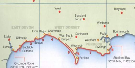
Figure 1. A general map (http://www.jurassiccoast.com 2006).
The Jurassic
Coast (see fig. 1) is a great place
to study sedimentalogy and paleontology.
The continual erosion of the coastline exposes more and more fossils to
be discovered. Lyme Regis is the
birthplace and life-long home to one of the earliest fossil gathers, Mary
Anning. She was an uneducated lower
class woman that lived in the early 1800’s that collected fossils as a child to
sell them to travelers then continued here quest the rest of her life. Some of her discovers were instrumental to
the development of the science of paleontology which has a huge role in
correlating geologic layers around the world and in affect developing the
tectonic history of earth.
Around the same time
Mary Anning was making her discoveries on the Jurassic
Coast an unbelievably intuitive man
named William Smith was developing some ideas of his own. Smith is the father of geology because of his
discovery of a constant succession in the rock strata all around England.
He dedicated most of his life to his masterpiece, the first geologic map. Smith made a geologic map of England
and Wales complete with a cross section which was published in 1819 and was
accurate for today standards.
Smith and Anning
are just two of the many people involved in an explosion of interest in the rock
layers and in the fossils. There were
many clerics, scholars, naturalists, and unique common people in England
that were starting to put the puzzle of earth together.
The common thought
that dominated the early nineteenth century in western civilization was very Christian-centric. Simon Winchester wrote a book about this era
called, “The Map That Changed the World:
William Smith and the Birth of Modern Geology”. The book is a great story
of the life of the father of Geology. In
his book Winchester goes into
detail about the power of theology during the nineteenth century in England. At one point in his explanation Winchester
writes about a bishop who had a strong influence of the popular beliefs for
hundreds of years.
“James
Ussher (1581-1656), Archbishop of Armagh, established that the first day of
creation was Sunday
23 October 4004 BC based on an intricate correlation of
Middle Eastern and Mediterranean histories and Holy writ (Winchester 2002).”
Ussher’s findings
were incorporated into an authorized version of the Bible that printed in 1701. That same version was still common in homes a
hundred years later. Furthermore, the
church’s belief was that all the creatures that God created still existed on the planet. So when the evidence that the earth was quite
a bit older than 6000 years and that there were extinct creatures preserved as fossils
started to accumulate the western world began a massive transition.
There has been an
explosion of new science in the past two hundred years. However, it is arguable
that many of the basic concepts of geology, paleontology and earth history are
yet to be accepted by the general public. Plate tectonics was not taught in school until
relatively recently. The “theory” of
evolution is still under suspicion in many parts of the United
States. The conflict between Earth Science and the
Christian religion rages on today. For
this reason the Jurassic Coast
and southern England
is very important to me as a geologist.
It is the Mecca of earth science.
The
Jurassic Coast
has been studied extensive by Geologists and Paleontogists. Countless papers have been written on various
subjects like the Kimmeridge Clays, Chisel
Beach, or the marine fossils at
Lyme Regis. To write a paper that
contained some original theory or a novel idea regarding the geology of this
coastline would take some extensive field work.
The idea behind this paper is simply to make some observations about the
coast and apply those observations to basic geologic processes. The goal was to make a documentary and modest
interpretation of the Jurassic Coast.
Geology of the Dorset Coast
The
Geology, landscapes, and human land use of the Jurassic
Coast are all directly linked to
each other. The rock beneath our feet
plays the biggest role in determining where a ridge of valley will develop or
what type of industry will there be.
Furthermore, the type of rock directly underneath the surface will
dramatically affect the fertility of the soil.
Farmland, stone quarries, and locations for towns all depend directly to
the landscapes and geology of the land.
Before
we can examine the focus area in detail there are some concepts and facts that
need to be clear. Depositional
environments of the sedimentary rocks of the Jurassic
Coast are important to review. A description
of the strata and their unique characteristic will help in understanding the
relative strength of the rocks. A brief tectonic history of area will aid in
our understanding of some landscape formations. Finally, a general review of
coastal and terrestrial erosion processes that are influencing the landscape
will be helpful as well.
Mesozoic Depositional Environments
In
the beginning of the Triassic period earth’s continents were group together in a
huge supercontinent called Pangea. This
massive landmass was located near the equator.
The majority of Pangea, including what we now call England
was far from any coastline. The climate
was dry and arid and the landscape was barren.
It is hard to picture England
as a desert, but that is exactly what it was 250 million years ago. The depositional environments that dominated
the Triassic period were terrestrial alluvial fan, river, floodplain and sand
dune environments (House, 1989).
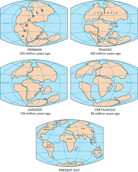
Figure 2: Tectonic history /
Continental Drift (http://www.jurassiccoast.com
2006).
During
the start of the Jurassic time period Pangea began to split apart (see fig 2). This was a very climatically significant geologic
event that created a new look for England. What is now called the mid-Atlantic rift was
forming right under what is now the British Isles. The rift continued to break the northern part
of Pangea, often called Laurasia into two separating continental plates. England
was now on the boundary of a continental. Furthermore it was an island or more
like a system of islands due to high sea level during most of the Jurassic and
even higher sea level in the Cretaceous (Sloan 1993). England
now had many coastlines and all of the diverse depositional environments that
come with the coast. England
was also still near the equator. Thus, the landscape looked much like the
present day Caribbean (Davies-Vollum, 2006).
There are many
different depositional environments that are associated with coastlines. The amazing thing is that they all exist
relatively close to each other. For
example; marine depositional environments that create different kinds of
limestone depending on exactly how far the environment is from the coast or
shoreline depositional environments with deltaic or tidal flat deposits or swampy
near shore lagoon depositional environments.
The presence of a shoreline, that was created during the early Jurassic,
helped diversify the depositional environments that existed in England
and more specifically, Dorset.
Relative Erosive Character of the Strata
Figure 3 is a
Stratigraphic column courtesy of Michael House who wrote The Geology of the Dorset Coast in 1989.
Note that the thickness of the beds vary throughout the Jurassic
Coast.
The Cretaceous
Chalk is the youngest and most resistant of all the sedimentary beds that are
present on the Jurassic Coast. This chalk is a very fine grained homogenous
limestone formed from the off-shore accumulation of fallen Nanoplankton.
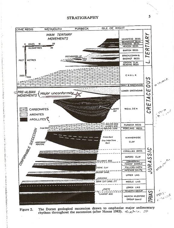
Figure 3 (please ignore the “Figure
2” above) (House 1989).
The Chalk is very resistant
to weathering. Flint
nodules are very common in the Chalk and are even more resistant than the chalk
itself.
Directly
beneath the Chalk is a relatively thin layer of cretaceous marine marl known as
the Greensand. This layer lives up to
its name; it really is green due to the percentage of the mineral
Glauconite. While the Lower Greensand is
much less resistant than the Cretaceous Chalk the Upper Greensand and Gualt is
only slightly less resistant than the Cretaceous Chalk.
The Lower
Greensand is completely missing in the eastern parts of the Jurassic
Coast. This is due to a large scale unconformity
that spans more and more of the Jurassic to the east. In figure 3 it is easy to see how the
unconformity gets larger to the east (House, 1989). The Gualt and upper Greensand were the first
layers to be deposited after the unconformity.
This means that on the east Devon coast Triassic
rock is directly beneath Cretaceous rock!
The
Wealden beds are below the Greensand and are also very susceptible to
erosion. These layers are made of a
mostly non-marine river bed and floodplain deposits. The Wealden marks the apex of a transgression
during the early Cretaceous. Mostly
sandstone and mudstone, these layers are not very resistant to physical
weathering and erosion. Good soil is
able to form on the areas where the Wealden is at the surface and grazing and
farmland is a common (Davies-Vollum 2006).
The
Purbeck limestone spans from the lower Cretaceous down to the upper Jurassic. The Purbeck is a large grained limestone full
of shells and fossils. Below the Purbeck
lies the Portland limestone that
consists of smaller grains of calcite clasts.
The Portland limestone, commonly
called “free stone”, is a high quality working stone for building. However, in the towns and villages of Dorset
both the limestones are found. The
more important characteristic of the limestone is their strength against
erosion. Despite their differences the
Purbeck and the Portland limestones
share this quality. Compared to
surrounding layers these limestones are very resistant and will often form
ridges.
The
Kimmeridge Clays are below the limestone layers. These are a complex series of clays and marls
that contain a very interesting organic rich layer pattern. There is enough oil in these beds that the
Romans actually used to burn the oil shales that were contained within the
Kimmeridge Clays (Davies-Vollum 2006). Like
the Wealden these layers are easily weathered and eroded and farmland is found
on the clay rich valleys that form where the Kimmeridge is at the surface.
Through
the middle and lower Jurassic there are cycles between thin layers of
limestone, shale, and sandstone. This
pattern represents minor transgression/regression periods. The most famous of these layers would be the
Upper, Middle, and Lower Lias. These layers are part of the lower Jurassic. It is common to find fossils, organic matter,
and calcite in these beds. Small local
difference in erosion rates appear and give the landscape a choppy look.
In
the Triassic there are mostly terrestrial sedimentary deposits. The upper Triassic has the Penarth group that
does have a thin layer of limestone and the Mercia
group below that is a mudstone. However,
the Otter sandstone is below the Merica and its all non-marine sandstones and
conglomerates below the Otter. The high
amount of iron in these beds creates the beautiful red in the cliffs of east Devon.
In general the
Triassic layers are easy to erode. The cliffs
form in part by the cretaceous rock, Golden Cap, which lies directly on top of
the Triassic due to the unconformity.
Tectonic History
There have been
three major period of deformation in that have affected the Dorset/Devon
region. In the Jurassic
Coast website a history of the
tectonic past reveals that in the exposures in the Triassic,
“…record evidence of the
gradual destruction and denudation of mountains formed in the Variscan orogeny
of 330-280 million years ago, and the establishment of a widespread marine
environment within a Jurassic basin, formed during the opening of the Atlantic
Ocean (http://www.jurassiccoast.com 2006)”.
The continual
break up of Pangea during the early Jurassic and the rifting (tension force)
that came with that created many normal faults throughout southern England. The last period of uplift occurred during the
Tertiary period (~10 million years ago) and was caused by compressional
forces. The Alps
were forming in neighboring Europe and the compression affected
the rocks east to Durdle Door and the Lulworth Crumple. Thrust faults and folds associated with the
formation of the Alps are common on the Jurassic
Coast. Some of the older normal faults were
reactivated in the compressional period and became reverse faults.
There are many
local tectonic complications on the Jurassic
Coast, but on a large scale there
is one major feature that is important.
Throughout East Devon and Dorset
the beds all dip to the east. This is
crucial to the succession of outcrops along the coast. The Triassic all the way to the Cretaceous is
exposed along the Coast.
Erosion Processes
The
shoreline processes along the Jurassic
Coast are spectacular in many
ways. Huge vertical cliffs, sea stacks
(see fig 4), headlands, and even arches are common sights. The differences in strength of the rocks,
wave diffraction and longshore currents are the factors that determine what
type of shoreline landscape will form. The
harder the rock the more resistant to the wave action it will be. Once a headland is created wave diffraction
may weather it back or isolate it, thus creating a sea stack (Greengrove,
2006).
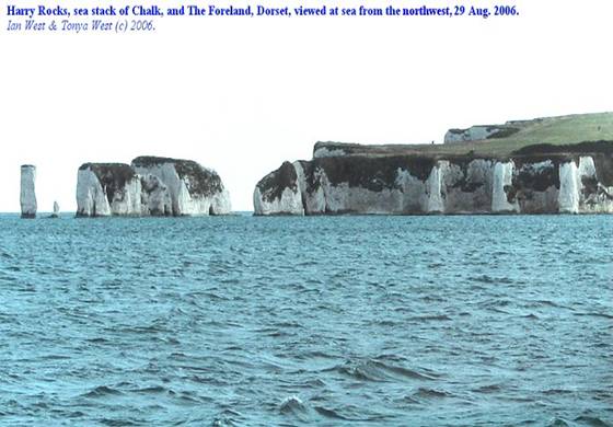
Figure 4: Old Harry Rocks (West
2006).
River systems are
the other major erosion force in the Dorset/Devon area. The landscapes that the rivers will form are
extremely dependent on the geology below the surface. The rivers will travel
the path of least resistance. Surface
water will simply flow over resistant rock and leave ridges or highlands while
eroding less resistant rock to form valleys or lowlands.
General Geology
The current day
geology of the Jurassic Coast
is quite complex. The periods of uplift
and subsidence of the area have left the sedimentary beds faulted and
folded. It is beyond the scope of this
paper to attempt to explain the history behind each piece. In general the layers dip slightly to east so
that there are younger rocks exposed to the east and progressive older rocks exposed
to the west. This is a unique
situation. If the beds were all
horizontal the Jurassic Coast
would not be well know. The slight dip
of the rocks and the fact that they occur on the coastline makes them ideal for
the study of sedimentology. Figure 5
shows a simplified cross section of the Jurassic
Coast.
 Figure
5: Cross Section (West 2006).
Figure
5: Cross Section (West 2006).
Landscapes and Land Use
of the Jurassic coast
River Mouth Towns
Most of the towns
and villages that are on the Jurassic
Coast were built on the less
resistant layers at the mouths of rivers.
A perfect example of this type of valley-coastline-town would be
Swanage. Located right on the coast,
Swanage sits in a valley between the Cretaceous Chalk and the Purbeck/Portland
Limestone ridges. The valley was craved
out by water because the less resistant Wealden lies directly between the two more
resistant layers. Creating a beautiful
and effective little fishing/port village with cliffs to both the north and the
south, but easy flat access to the ocean.
Many of the towns along the Jurassic
Coast exist in very similar
situations as Swanage. Exmouth, Budliegh
Salterton, Seaton, Lyme Regis, Charmouth, Bruton Bradstock, and West
Bay are all towns located at the
mouths of rivers that have cut into easily eroded rock (see Figure 6).

Figure 6: An example of a river
mouth town (Charmouth) and ridge formed by the Cretaceous Golden Cap (West
2006).
Natural Harbors
Weymouth
has a complex and fortified landscape that makes it a very good harbor
town. The isle of Portland
is connected to Chisel Beach
to the north (see fig 1). Together they
protect Weymouth Bay
by creating an eastern sea block. Breakwaters
have been added to the west to further protect Weymouth.
The Isle of
Portland is the southern limb of a large dome structure that extends to the
north (Jurassiccoast.com 2006). The peak
of the dome has been eroded away and what we see at the isle of Portland
is the resistant limestone that slopes gently to the southwest. Portland
has great access to the sea and an abundance of great building stone. The Isle of Portland has been quarried for
hundreds of years.
Lulworth Cove is a
superb example of how the geology can affect the landscape. Locally there is
dramatic folding of the rock layers.
Right on the coast the layers are tilted nearly 90˚ vertical. The
Purbeck/Portland limestone had put up a mighty effort to resist the sea. However, a geologically recent breach was
made as the limestone gave way to the wave action. Ever since the breach the less resistant
layers behind the Limestone, the Wealden and Greensand, have been eroded more
quickly than the limestone as well as the Cretaceous Chalk that acts as a backstop. Lulworth Cove is a very symmetric little
bay. It continues to grow laterally as
time goes on. It is interesting to
contemplate what the future holds for Lulworth Cove.
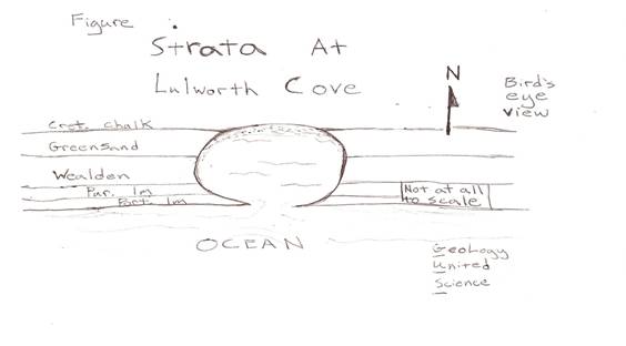 Figure
7: Rough Sketch (GUS 2006).
Figure
7: Rough Sketch (GUS 2006).
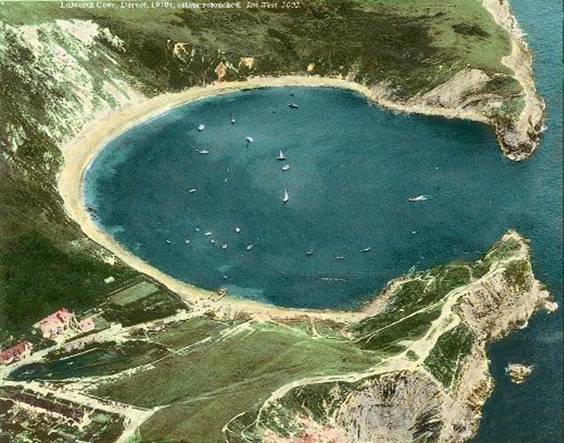
Figure 8: Lulworth Cove (West
2006).
In Figure 7 and 8 it is easily see
where the limestone has been breached and the less resistant beds have been
eroded more quickly than the Chalk.
Quarrying and Smuggling in Beer
Beer is located in
a very picturesque and secluded setting. There is a normal fault to the east of
beer that takes the Cretaceous down to the Triassic. This is deceiving however because at this
locality there exists an unconformity of about 100 million years. So, the offset is not quite as significant as
you might think, but still impressive. Figure 9 shows a cross sectional view of the
geology around Beer.
Figure 9: Geology at Beer (West
2006).
Even though the hanging wall of the fault is made
of hard Chalk a river has eroded through it and down to the sea. The Beer syncline surrounds the town with
steep sharp cliffs on either side of the town.
The Chalk creates large cliffs and headlands that protrude out into the
sea from either side of town.
Beer is well known
for its world class building limestone, the Beer Stone. The Beer stone is a thin layer that lies
beneath the massive Cretaceous Chalk layer and is accessible at the base of a
local hill where the layer dips down below the ground level. At this locality there is a network of man-made
caves for quarrying this pure-white limestone.
The caves are quite extensive and contain a lot of history.
John Scott is a
very knowledgeable tour guide at the Beer
Caves. He grew up in Beer as did his family for
generations. Scott has a great passion
for the stories about the workers in the caves and of the town of Beer
itself. The Romans were the first to use
the cave quarry. According to Scott, the
Romans followed the Beer stone layer as it dipped from a nearby cliff to the
base of a the hill (Scott 2006). The Romans must have known that the stone
would be there if they dug into the ground.
From a geologic perspective, the fact that they were able to understand
that stratrum can be continuous over large areas is breathtakingly ahead of
their time.
Many of the other stories that came from the Beer
Caves were related to smugglers. The seclusion of the town of Beer
made it an ideal place for smugglers to avoid the harsh customs of any imported
good coming into England
in the eighteenth and nineteenth centuries.
The quarrymen, with their hands-on knowledge of the caves used to store
the smuggled goods in the Beer Caves
(Scott, 2006).
Fossils and Landslides
Near the towns of
Lyme Regis and Charmouth the exposures along the coast are mostly Jurassic
sediments. World famous landslides are
occurring in this area. The Black Ven,
Shales with Beef, and other Lower Lias members are
capped by the Cretaceous Greensand. This
creates a situation where the cap rock produces a cliff, but the underlying
rock is too fragile to support a steep cliff.
What happens instead is a very dynamic terraced landscape forms and is
continually eroded by the sea. The
significance of this is that there are always new exposures and thus new
fossils to be found amongst the landslides and the marine-reptile fossil rich
beds. Mary Anning was known for always
venturing out to the landslides when there was a storm in hopes for a new
landslide face. In the picture below
(fig 10) the terraced landslide can be seen clearly.
Figure 10: Black Ven Landslides
(West 2006).
The Isle of Purbeck and Corfe Castle
One of the most
significant landscapes in Dorset for humankind would
have to be the Isle of Purbeck. This
small broad peninsula is not technically an island (see fig 11).
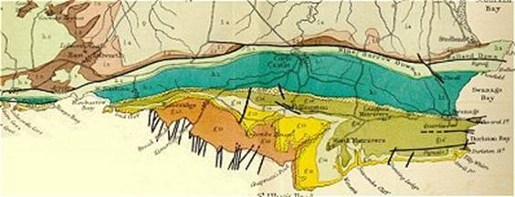
Figure 11: Geologic Map of the Isle
of Purbeck (West 2006).
There is a large
ridge made out of the Cretaceous Chalk that separate a small broad peninsula
from the rest of England. The structural geology of the isle of Purbeck
is basically that all the beds dip to the north. The whole area is part of what is known as
the Purbeck monocline. The affect of
this geology is that the resistant beds, the Chalk and the Cretaceous/Jurassic
Limestone, form two ridges and the Wealden is eroded between them to form a
valley.
During medieval
times the chalk ridge was effectively a barrier from the rest of England. The Isle of Purbeck was literally in
isolation. Virtually the only way to get to and from the isle, without using a
boat, was to go through the town of Corfe. Corfe is located at one of the only breaches
in the chalk ridge. For some reason the
chalk was weakened here and a small river was able to erode through creating a
gateway into the Isle of Purbeck. Corfe
was obviously a very important town for the trade industry in Dorset.
The river that cut
through the chalk split on the north side of the chalk ridge from one river (evidence
that the Isle of Purbeck is an island after all). Due to the two separate rivers cutting
through the chalk nearly parallel to each other an impressive hill has been
created. This chalk hill stands alone
with steep sides in every direction (see fig 12). It’s the perfect location for a castle; in a
major gateway town and in an ideal defendable position. In fact Corfe
Castle which stands in ruins yet
proudly at the top of this peak and was a stronghold for royalty during the English
Civil War.

Figure 12: Corfe
Castle and Chalk Hill (West 2006).
Land Use
The most obvious
use of the land in Dorset is the use of stone for a
building material. Rock fences, rock
homes, entire villages and towns built out of mostly limestone. In London
you’ll find stone from the Dorset Coast
in such buildings as St. Paul’s Cathedral
or in Swanage the post office or the Lyme
Regis Museum.
Tourism
has as been a major use of the land in the past and will continuing to be in
the future at the Jurassic Coast. The stunning beauty of the cliffs, sea stacks,
coves, beaches, and quaint ocean side towns is certainly worth the trip. Fossil
exploration is a scientific endeavor, yet the towns of Lyme Regis and Charmouth
have definitely been able to turn it into a leisure activity as well.
Farming
and grazing are other major uses of the land in the Dorset
and east Devon area.
As mentioned earlier the agricultural areas are found in the clay-rich
river basins that drain off the more resistant rock layers. A good example of a fertile river valley
would be the valley between the chalk and the limestone on the Isle of
Purbeck. Let me tell you, they are doing
something right because I’ve seen the pigs they grow out there and they are
enormous!
Conclusion
I hope it has
become obvious that there is a huge connection between geology, landscapes, and
human societal infrastructures. The Jurassic
Coast is not the only place where
this connection exists. Most people
don’t realize what type of rock is under their feet and how that affects the
lives of everyone around them. The fact
is that it matters a great deal and understanding geology will provide
knowledge which will help us be smarter, make better use of the landscapes, and
become more effective when building new infrastructures.
On a personal
note, I would like to say that until recently I had no clue the Jurassic Coast
World Heritage Site even existed. For
that matter I had no idea the UNESCO existed. I’ve learned that “World Heritage Site” is
just another way of saying “International
Park”.
I was fortunate
enough to take a course through the University
of Washington at Tacoma
where we spent two weeks in Dorset. I see now why this area is so well
protected. The Jurassic
Coast is a wonderful place in many
different ways. I encourage anyone who
has read this paper to check out some of the references of this paper to learn
more. I especially recommend the website
done by Ian West. Most. Most of the
figures from this paper come for this unbelievable website.
References
Boggs, Sam Jr. (2001) Principles
of Sedimentology and Stratigraphy,
third ed., Upper
Saddle River,
New Jersey, Prentice Hall, 726 pp.
Davies-Vollum, Sian , Phd, Professor
of Sedimentalogy, University of Washington
of
Tacoma, 2006.
Greengrove, Cheryl, Phd, Professor of Oceanography, University
of Washington of
Tacoma, 2006.
House, M. R., Lister, C.J. (1989) Geology of the Dorset Coast, Geologist
Association
Guide, 43 pp.
http://www.jurassiccoast.com
(2006) Jurassic Coast Dorset and East Devon: World
Heritage Site, UNESCO.
Scott, John (8/3/2006)
Live Tour of the Beer Caves,
Jurassic Coast
World Heritage Site
Solan, V.F.,
Birkeland, P.W. (1993) Introduction
to Physical Geology: Lab Manual,
third
ed, University of Colorado,
Upper Saddle River, New Jersey,
Prentice Hall,
287 pp.
West, Ian (2006) http://www.soton.ac.uk/~imw/index.htm,Geology
of the Wessex Coast.
Winchester,
S. (2002) The Map That Changed the World:
William Smith and the Birth of
Modern Geology,
New York, HaperCollins Publishers Inc. 352 pp.
Home
Back to Student Project

