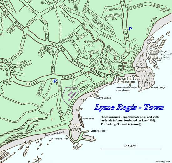
Lyme Regis
No
Longer Slip-sliding Away
Elizabeth Johnson
Geology in
Summer, 2006
(West, 2006)
Introduction
Lyme Regis is located in
First, Lyme Regis is located on an exposed part of the shoreline, where there is no natural harbor and manmade structures are necessary to provide both a boat haven and protection from storms. The Cobb is the town’s jetty that extends into the sea, providing both harbor and defense. It dates at least to the 13th century, has been destroyed by storms and rebuilt numerous times. Without The Cobb, there would be no town.
Second, Lyme Regis is built on a steep and actively eroding hillside, which has suffered major landslides in the past and is certain to experience more in the future. The geologic makeup of the hillside consists of a limestone base followed by layers of clay and topped with sandstone and sandy soil. This combination of sand over clay makes the cliffs inherently unstable. These clays are also loaded with fossils and have made the town internationally famous among scientists and fossil hunters. Unfortunately, clay does not make a good foundation for buildings. Lyme Regis’ treasure is also its curse.
In this paper, I plan to provide a brief history of Lyme Regis and The Cobb, and describe the geology that makes this a unique area. Then, I will discuss the current work being done to upgrade both the beaches and the town, which are intended to prevent or delay the erosion process and in the process improve the tourism industry for the town.
(West, 2006)
A Very Brief History
I imagine the shoreline of Lyme Regis in the Neolithic or Stone Age was quite different than today. Perhaps the river Lym was more significant than it is today; maybe there was a promontory or natural harbor that has long since eroded away. Evidence of human occupation in the area has been discovered in the form or stone tools, (Chapman & Clayton, 2006) so we know that prehistoric people at least passed through. If there were some natural estuary or protection from the elements, early people might have decided to stay a while. Although Roman occupation of the Southwest coast began in the first century Common Era (CE) no archaeological evidence has been found that they inhabited Lyme (Historical Appraisal, August 2005) the first written documentation of the town appears in 774 when Cynewulf, King of Wessex, gave land near the mouth of the Lym to the Abbot of Sherborne, who set up a salt works. After the Danes invaded for a second time in 840, Alfred provided ships to be harbored at Lyme. This is the first historical documentation of a harbor. (Roberts, 1834) What isn’t clear is whether the harbor was manmade or natural at this point in history.
Salt was the main industry of Lyme until1250, when Axmouth harbor was made useless by a major landslide at Haven Cliff. Lyme took advantage of the opportunity and developed their harbor for ships. Gradually, shipping took over as the main industry. Lyme added “Regis” to its name in 1284, when Edward I granted its charter.
The Cobb, a
dominant and beloved feature of Lyme Regis, is
actually a jetty extending into
After suffering
several more destructive storms, the southern arm was added in the 1690’s and
replaced in 1793 after another storm destroyed it the previous year. In 1750, The Cobb was connected to the shore.
In 1793, construction employed a new technology and made use of mortared
stone. The Cobb was entirely rebuilt
using Portland Stone and mortar in 1820. (Wikipedia, 2006) This is The Cobb you see today when you
visit Lyme Regis.
It is classified as a “Grade 1 listed building”. This listing puts The
Cobb on the same level of historic significance as
Lyme Regis enjoyed a long period as an important port,
trading with
English society
had long been accustomed to traveling out of the cities during the summer
months to escape the heat and diseases that bred there.
During the 19th
century, with the emerging science of geology and the radical idea of “deep
time” (the notion that the earth is actually older than biblical accounts say
it is), it became fashionable in elite society to collect fossils. This was an age of curiosity and scientific
discovery, providing the people of Lyme Regis with
yet one more source of income – fossil hunting.
With the Blue Lias to the west and Black Ven to the east, Lyme Regis was
and is a fossil-hunters
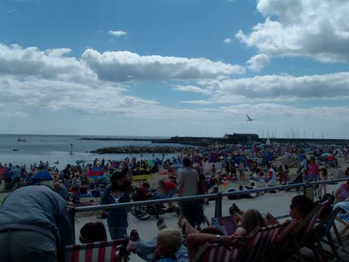
When The Cobb was connected to the shore, the long-shore drift was cut off no longer supplied material to the beach. Then a seawall and promenade were built during the 19th century, which had unintended consequences. The beach was isolated from the land and it lost an important source of sand and shingle from the constantly eroding hill above. The beach became depleted, continued to erode and, without sand and shingle to protect it, the seawall was being undermined by the waves. Tourists like nice, sandy beaches. They chose other locations for their holidays, and Lyme went into decline.
Landslides in Lyme
Erosion, landslips
and landslides have been a feature of the Lyme Regis
coastline since before humans inhabited the area and each event exposes more
treasures: clues to earth’s ancient beginnings. Much of the original medieval
town has been lost to erosion and landslides and, although efforts have been
made in the past to slow or prevent them, they continue to plague the
town. On Christmas Eve 1839 there was a
tremendous landslide in the area known as the Undercliffs
(
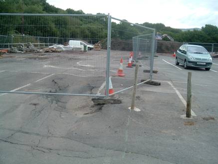
The unique geology of this area makes Lyme Regis particularly prone to landslips. Lyme Regis is in a syncline with a Blue Lias base, followed by Shales with Beef and Black Ven topped with a bit of Greensand and chalk. Simply put, the town sits on stone, clay and then sand. Clay is impervious and slippery, and sand is porous. Since water cannot drain freely through clay and limsone, it is flows through cracks to the interfaces between the Blue Lias and clay. The combination of water and clay makes slurry and reduces the friction between the surfaces. The water fills the sand, making it heavier. Landslides are inevitable. When structures with impervious surfaces such as roads and car parks are added, the increased weight of the asphalt can worsen the situation.
The areas of Langmoor and
Later, when a
paved car park was built above
Please use this link for related maps, photos and diagrams:
http://www.dorsetforyou.com/media/pdf/0/f/Lyme_Regis_Leaflet6ppfinal_-web.pdf
The Lyme Regis Strategy Plan
In the early 1990’s the West Dorset District Council, Engineering Division began the process of developing a Strategy Plan for Lyme Regis (2002).
This plan begins
with a detailed study of four areas: Cobb Gate and the Harbor (Phase II),
In Section 3.2, the plan addresses the Recommended Generic Objectives:
Lyme Regis is faced with a formidable array of coast protection challenges. In order to fulfill the recommendation of ‘hold the line’ in the Shoreline Management Plan, it is considered that there is no other realistic alternative in the long term other than to implement new coast protection schemes….
As the probability of damage due to marine erosion and landsliding are both relatively high, there would be little benefit in implementing foreshore protection works without also carrying out slope stabilization works, and vice versa.
In other words, the recommended strategy recognizes the need to treat the upland and shoreline as a system, rather than treating them as separate, non-related problems. With this in mind, Section 3.3 addresses the alternatives.
The alternatives include ‘do nothing’, ‘do the minimum’, ‘react to failures once they have occurred’, ‘early warning systems’ and ‘coast protection works’. The first three philosophies are dismissed because they are “Discordant with Preferred Strategic Options of the Shoreline Management Plan”. The study suggests that ‘do the minimum’ is acceptable only in non-urgent cases, and in the short-term. This philosophy is not considered sustainable in the long term. The ‘react to failures’ philosophy is what has historically happened and is also undesirable, as “remedial works to treat a failure once it had caused the damage would be significantly greater in cost than those required to prevent the failure in the first place.”
In the end, the Strategy Plan recommends implementing a limited early warning system in high-risk areas and comprehensive coast protection works:
Coast protection works: major strengthening works comprising improvement to the coast protection walls, the provision of beach renourishment and control structures, slope stabilization and drainage works, is considered to be the only realistic philosophy which will meet the objectives of the Shoreline Management Plan.
The only place where the ‘do
nothing’ plan was adopted was Phase
This report was precluded by extensive research performed by the West Dorset District Council, along with consulting engineers High-Point Rendel that included in-depth studies of the coastal system, from the sub-tidal zone to the top of the coastal slope (Engineering Division Preliminary Studies, 2000).
It’s difficult to list all the areas that were studied. They researched the history of landslides and development of coastal structures, performed external and geophysical surveys of the coast protection structures, did bathymetric surveys, side scan sonar surveys, shallow sub-bottom profiling, grab sampling, marine seismic profiling and seabed videoing. They took aerial photographic surveys of beaches and landslides, and did geological mapping of the area. That was just the beginning. They analyzed of the coastline evolution, beach changes, landslides, water, rainfall, and cored boreholes to gain subsurface data. They performed slope stability analyses and investigated existing drainage systems. As a result of these studies, they were able to put together the most comprehensive picture of Lyme Regis’ geological and coastal condition ever.
Along with being able to identify the extent and
types of the landslide systems, the study recognized that where there was once
a substantial beach along the Lyme Regis frontage it
had since disappeared. The beach has
declined due to a number of reasons, both natural and man-made. First, there is
no longer a natural supply of beach-forming shingle along the coastline. This is “part of a natural process of
fragmentation of the beaches along the
Coastal Protection
The next step in the process was to design
protection for the shore and slope. Coastal engineering begins with
calculations of wave height, length and energy, current, beach slope etc. It
also depends upon proving the calculations by testing the design in a wave tank
before actually building the structure.
As part of these studies, preliminary engineering was begun on Phase II.
Part of the process involved 1:500 scale model tests of the shoreline system. This testing was performed at the HR
Wallingford testing facility in
The entire Lyme Regis
harbor, from The Cobb to Cobb Gate, has undergone major rehabilitation. Beacon
Rocks, at the end of The Cobb, were realigned and extended by 110 meters. The
North Wall Rockery was realigned. New
jetties were built below
Finally, sand and shingle (pebbles of about 50 – 75
mm diameter) were placed on the beach, raising it by 2 meters. While the entire beach was initially to be
covered with shingle, public opinion and consideration of the tourism industry
that supports the town swayed the design and portion of the beach has been
replenished with sand. Thus, the most
protected section of beach, between the North Wall Rockery and
The reason the entire beach isn’t covered in sand is because sand is too lightweight. The wave testing proved what the engineers suspected – sand would not provide sufficient energy absorption to protect the seawall from the waves. In addition, it would wash away too quickly from less protected areas of the shoreline. It is anticipated that the sand beach will need to be replenished every 5 years.
Lyme Regis sand beach, August 2006
Every stone size, from sand to armor rock, was carefully selected for optimum durability, size, weight and aesthetics.
Although to you and me it might look like a pile of
rocks, the actual design and construction of the Beacon Rocks extension is
highly technical (Combes, 2006). This extension is designed to protect Lyme Regis from the most severe storm waves. First, the sea floor was dredged to a
suitable and stable base. Next, core
rocks ranging in size between 2 and 5 tonnes each
were placed. Then
comes the tricky part. Armor
rocks sized from 9 to 18 tonnes were placed using
Global Positioning System (
The sand and shingle were brought in on barges and transferred to smaller barges, which were able to enter the harbor at high tide and dump their loads near the shore. Then, at low tide, heavy equipment was used to push the sand and shingle up onto the beach and spread them in the desired locations.
The jetties are constructed of a precast concrete core installed on a poured foundation, then faced with cut limestone.
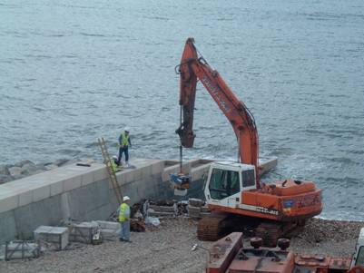
Finishing up the Cobb Gate Jetty,
August 2006
Construction and The Benefits of a Global
Market
There is a truly global element to the shoreline
construction materials (Combes, 2006). Armor rocks were quarried in
The sand, shingle and limestone were selected for
size, weight and durability, and also for appearance. The coastal protection
work was completed in August 2006.
Upland Stabilization
As previously noted, this project also involves
slope stabilization. Work on Langmoor and
The entire slope stabilization project was a
delicate process, and the contractors used extreme care to avoid triggering
another landslide during construction.
Equipment size was very limited and only increased as more slope
stability was achieved. A total of 1150
piles were auger-cast (drilled into the ground and filled with concrete) rather
than driven to prevent excessive vibration of the slope. The 300 mm diameter piles were drilled
through the soil and clay and into the limestone bedrock in the Langmoor and
To monitor slope stability, strategic piles and ground locations are fitted with inclinometers (Childs, 2006). The inclinometers are constructed of a plastic pipe or casing with 4 grooves equally spaced around the inside surface. The casings for this project are up to 29.5 meters long. An inclinometer probe is a stainless steel cylindrical instrument, about 25 mm in diameter and 800 mm long. It is fitted with spring-loaded wheels near each end that are designed to run along the grooves in the casing. This probe is inserted into the bottom of the casing and pulled through, taking measurements at 1/2-meter increments to determine deflection and thus ground movement. Measurements are recorded at initial installation and predetermined intervals thereafter. Construction equipment sizes are only increased after inclinometers indicate sufficient stabilization. For this project, the inclinometers are checked daily or weekly through the construction process, depending upon the level of activity and will continue to be monitored at less frequent intervals after construction is complete.
After the stabilization work is complete, 7,500 square meters of gardens will be re-planted for the enjoyment of both residents and tourists alike.
Conclusion
Lyme Regis is a beautiful town. It has a rich history and fossil content, with the advantage of a mild climate (except for when there are storms) and incredible views. This is a place worth preserving.
It’s impossible to eliminate slope failures and coastal erosion, but damage to property and loss of life can be minimized with a comprehensive and proactive plan. Previous attempts at addressing these issues were done on a piecemeal basis and did not consider the area as a system but looked only at the local and immediate problem.
The measures taken by the Dorset County Council and Lyme Regis are comprehensive in scope, consider both shore and slope as a system and go a long way to slowing processes of erosion and landslides while at the same time provides the tools needed to respond proactively in preventing future landslides. The Council worked with engineers and citizens to develop a plan that meets the needs of the people of Lyme Regis. Tourists have again returned to the beaches.
This project returns Lyme Regis to its rightful place as “The Pearl of Dorset”.
References
Lyme Regis Walkabout , (Chapman & Clayton, 2006)
Serendip Fine Books
A History of the Town, (Fox, Richard J., MBE)
Widipedia.com, 2006
http://en.wikipedia.org/wiki/Lyme_Regis#The_Cobb
Dorset County Council website:
http://www.dorsetforyou.com/media/pdf/0/f/Lyme_Regis_Leaflet6ppfinal_-web.pdf
http://www.dorsetforyou.com/media/pdf/b/2/Lyme_Regis_display_-_p_1-6_web.pdf
http://www.dorsetforyou.com/media/pdf/m/3/Lyme_Regis_display_p7-12_-_Web.pdf
Engineering Division
Notes on Lyme Regis Environmental Improvements
Preliminary Studies (2000)
http://www.dorsetforyou.com/media/pdf/e/c/Notes%20on%20LREI.pdf
Lyme Regis Strategy Plan (2002)
http://www.dorsetforyou.com/media/pdf/8/d/Strategy_Plan_August_Web_Version.pdf
Historic Appraisal (2005)
Lyme
Regis,
http://www.dorsetforyou.com/media/pdf/2/p/R02_Historical_Appraisal.pdf
The Philpot Museum Lyme Regis website:
http://www.lymeregismuseum.co.uk/undercliff.htm
Geology of the
http://www.soton.ac.uk/~imw/Lyme-Regis-town.htm#landslides
Personal Interviews, August 2006:
Combes, Eric, Bsc Ceng MICE
Management Consultant, High-Point Rendel
Lyme Regis Environmental Improvements Phase II
Childs, Peter
Project Manager, Datum Geotechnical and Structural Monitoring
Back to Student Project