| Harvest Scheduling | 14 |
This chapter will discuss the inputs and outputs of the SNAP program and how SNAP was used to schedule road construction and create a harvest plan for the Washougal. The SNAP program uses information from two GIS coverages and an FVS growth model to determine when roads should be constructed as well as when harvest units should be put up for bid. SNAP then attempts to maximize the value of wood at the mill by minimizing road construction, harvest, and haul costs. SNAP was especially useful for scheduling the Washougal since HCP requirements dictate fifty percent of the watershed must be Spotted Owl dispersal habitat.
SNAP Inputs |
SNAP uses two GIS coverages to analyze an area: a polygon coverage of the harvest settings, and a line coverage of the proposed road network. The polygon coverage was digitized into ArcInfo based on probable landing locations and reasonable external yarding distances. Into each of these setting polygons, 14 attributes were added:
- AREA The harvestable acreage of the polygon
- ENT1 The number of the road node where the timber will be harvested to
- SIL1 Candidate silvicultural treatment # 1
- SIL2 Candidate silvicultural treatment # 2
- SIL3 Candidate silvicultural treatment # 3
- STAT Used to tell SNAP when a unit must go. DNR sales were hardwired in the 1st period
- SPE1 Used to identify different species, we used only Douglas-Fir
- VOL1 Volume per acre of SPE1 in MBF
- DEF1 The percent defect for SPE1
- SERS The current seral stage of the unit
- HAR1 Candidate harvest method # 1 for the unit
- HAR2 Candidate harvest method # 2
- AT01 An optional attribute used to tell SNAP which units were in HCP designated areas
- AT02 An optional attribute used to tell SNAP which units were not owned by the DNR
The road coverage was digitized onto the existing DNR TRANS coverage. The proposed roads were digitized using field notes and maps. For each road arc, 8 attributes were added:
- RDST The status of the road, existing, reconstruct or new construction
- TERT The terrain type of the road used in construction calculations
- ACLC The type of road, arterial, collector or local
- RDTY The road type, paved, gravel, etc.
- AVGR The average grade of the road
- AVSP The average speed on the road
- AVGS The average side slope along the road
- FXOR Used to tell SNAP a fixed override cost for road construction, like a bridge cost
Harvestable Area |
Because portions of setting polygons fall within riparian buffers, the harvestable area of each setting polygon as defined in SNAP is actually less than the total area of each setting polygon. The harvestable area value corresponds to the total acreage of each polygon available for harvest, which excludes the riparian areas. This value is used to calculate the total volume of each setting polygon. The total area of each setting polygon includes portions within riparian buffers. The total area of each setting polygon is used to calculate average yarding distances.
Growth Rates |
SNAP models the ways in which stand volumes change over time based on a series of decision trees. The decision trees contain average annual growth rates for each scheduling period based on the age and operational history of each stand. SNAP has the option of performing certain user-specified silvicultural treatments based on the seral stage of each stand (the term seral stage is somewhat of a misnomer in this context as it refers to the age and operational history of a stand rather than its structure).
Stands that are never treated will increase in volume at the user-specified passive rate. When a silvicultural treatment is performed the appropriate volume is removed from the stand inventory and the stand continues to grow along a new branch of the decision tree.
For example, in the following sample table, SNAP may choose to do nothing or to perform a pre-commercial thin at seral stage "10-14". If no operation is performed the stand volume will continue along the passive-rate branch, moving on to seral stage "15-19" and increasing at a rate of 7% in that period. If a pre-commercial thin is performed, 30% of the volume will be removed and the stand will thereafter grow along the PCT-rate branch. It will move on to seral stage "15-19 PCT," increasing at a rate of 11% in that period.
SNAP has the option of performing other operations such as commercial thins and clearcuts in later seral stages. Clearcuts reset stands to the initial seral stage "0-4."
Sources of Growth Rates
Growth rates were developed from the "West Cascades – Gifford Pinchot" variant of FVS (Forest Vegetation Simulator) using the LMS (Landscape Management System) interface. Watershed-average growth rates were developed in the absence of management, after a pre-commercial thin at age ***, and after a commercial thin at age ****. More information on timber inventory and growth modeling are included in chapters 6 and 10.
Limitations of SNAP Growth Modeling
The accuracy of SNAP's modeling of changes in landscape volume over time is limited both by the quality of the initial data and by the low degree of growth rate variability SNAP can recognize within a landscape.
Chapters 6 and 10 discuss the likely errors in the estimates of initial volumes and future growth rates in some detail. In general, the initial volume values may be reflective of actual landscape conditions while the growth rates are likely optimistic.
The degree to which SNAP can recognize inter-stand variation in growth is limited by the number and level of detail of the decision trees it is given to work with. Each additional decision tree requires a new set of growth rates for each possible operational decision. Every time the number of decision trees is doubled the scheduling optimization process becomes as much as four times longer and more complex. In practice, landscape variation is limited to the variation of the initial volumes. Thereafter, every stand of the same age and operational history grows the same way.
Table 14.1: Sample SNAP Growth Rate Decision Tree
| SERAL STAGE | POSSIBLE TREATMENTS | VOLUME REMOVED | PASSIVE RATE | CT RATE | PCT RATE | NEXT STAGE |
| 0-4 | None | None | 60% | 5-9 | ||
| 5-9 | None | None | 20% | 10-14 | ||
| 10-14 | None,PCT | None, 30% | 9% | 11% | 15-19, 15-19 PCT | |
| 15-19 | None, PCT | None, 30% | 7% | 10% | 20-24, 20-24 PCT | |
| 20-24 | None, PCT, CT | None, 30%, 40% | 6% | 9% | 8% | 25-29, 25-29 CT, 25-29 PCT |
| 25-29 | None, CT | None, 40% | 5% | 8% | 7% | 30-34, 30-34 CT, 30-34 PCT |
| 30-34 | None, CT | None, 40% | 4.5% | 7% | 6% | 35-39, 35-39 CT, 35-39 PCT |
Cost and Revenue Inputs for SNAP |
Construction Costs
There are many ways to enter costs into SNAP and only one way to enter revenue. All the costs that were input into SNAP come from research that was conducted. More about the costs that were used can be found in Chapter 8. For road construction costs, we used three construction categories (see Figure 14.2) as well as some fixed costs for roads with bridges or other expensive construction practices. Roads with side slopes less than 30% were considered to be cut/fill. Roads with side-slopes between 30 and 45% were assumed to be full-bench but not end-haul and anything over 45% was assumed to be end-haul. Most of the roads in the watershed fall in the greater than 45% category.
Table 14.2 Road Construction Costs Based on Side-slopes for Input Into SNAP
|
Slope Classes |
< 30 % |
30 % to 45 % |
>45 % |
|
Road Cost Per Mile |
$52,000 |
$73,000 |
$132,000 |
Harvest Costs
Harvest costs in SNAP are entered two ways, $/MBF and $/MBF/ft (a function of yarding distance). Harvest costs for the different systems are outlined below (see Figure 14.3). Notice that there are two of each of the yarders, one for short spans and one for longer spans. Yarding costs increase significantly as the external yarding distance (EYD) gets longer than approximately 1500 feet.
Table 14.3 Yarding Costs Used in the SNAP Analysis
|
Editor Line # |
System Name |
System # |
Total ($/MBF) |
Max EYD |
Yarding ($/MBF) |
Yrd Coeff. ($/MBF/ft) |
Other ($/MBF) |
|
1:* |
Skidder |
1 |
500 |
95.00 |
0.0000 |
||
|
2:* |
Tower |
2 |
1100 |
88.00 |
0.0250 |
||
|
3:* |
Swing |
3 |
1100 |
90.00 |
0.0250 |
||
|
4:* |
Helicopter |
4 |
7500 |
240.00 |
0.0050 |
||
|
5:* |
Tower (long) |
5 |
2500 |
90.00 |
0.0320 |
||
|
6:* |
Swing (long) |
6 |
2000 |
92.00 |
0.0320 |
||
|
7:* |
No Harvest |
7 |
|||||
|
8:* |
No Harvest |
9 |
Table 14.3 shows the yarding cost editor in SNAP. The Max EYD column uses the Maximum external yarding distance to determine eligible harvesting systems. The column Yarding $/MBF is a base equipment and felling cost. Yrd Coeff. $/MBF/ft is coefficient multiplied by the AYD. These two costs are added together to make up the Total Cost $/MBF per setting unit. The column Other $/MBF in this case is left blank. It could be used for other costs such as felling. In our case felling costs are included in the base cost. Using an example Tower yarding at AYD = 500 ft the cost would be $100.50/MBF, at AYD = 1000 ft. the cost would be $122/MBF. Therefore, stump-to-truck costs are variable for each harvest setting.
Haul Costs
Haul costing is done using the average MBF load per truck and the average cost of trucking per mile. For the Washougal we assumed $1.07 per minute for hauling with a load of 4.2 MBF. These estimates are based on current conditions in the watershed. Haul costs for each setting are based on the round trip distance to the mill and the speed of the truck. Haul cost is appreciated over time at 3% a year but the MBF per truck remains the same. Realistically, as the trees in the Washougal grow, truck loads might increase to around 5 MBF per load. Road maintenance costs are also calculated as part of the haul cost. We assumed $1.50 /MBF/Mile for DNR roads and no maintenance costs for the county roads.
Mill Revenue
Revenues are generated at the mill. We specified one mill in Camas that currently pays $575.00 per MBF for Douglas fir. This mill price is appreciated over time at 1/2 % higher than the other costs in the program, at 3.5% a year. Multiple mills can be designated in SNAP but we used just one for comparison purposes.
Harvest and Transportation Schedule |
The following five maps show the watershed at five year intervals over the next 25 years. Each map shows the roads that are constructed during that time period as well as the specific harvest units that are put up for sale. To comply with FPA rules, adjacency and maximum harvest acreage constraints were set. The maximum adjacent harvest area was set at 85 acres. FPA rules allow for 100 acres but since we did not include riparian acreage in our harvest settings we had to account for those acres. We assumed that, on average, 15 out of every 100 acres in the watershed was in riparian buffers and therefore set the maximum adjacent acres at 85. Adjacency was defined as units younger than 10 years that share more than 100 feet of common boundary.
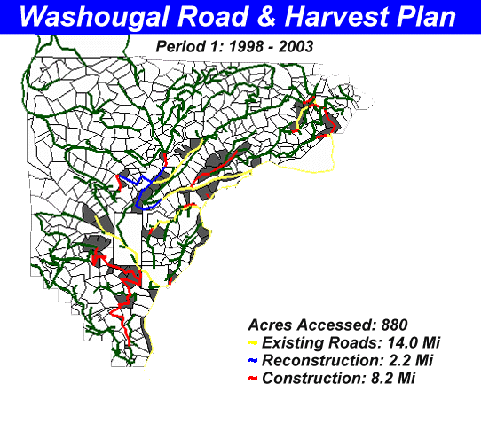
Figure 14.1 Road and Harvest Schedule based on SNAP analysis, 1998-2003, 4,000 MBF/year
Period 1, 1998 - 2003
For this first map (figure 14.1), three DNR sales were hardwired into SNAP. The Prospector pole sale, Miner and Silver Creek sales were forced to come out in the first period. It is interesting to note that SNAP's schedule differs little when those sales are not forced. In this first period 10.4 miles of road is constructed or reconstructed. The w - 2070 and the old Mine Creek road are reconstructed with a 70 ft bridge at the w - 2070 / Mine Creek junction. The cost of constructing the bridge is well offset by the volume of timber that is hauled over the Mine Creek road over the next 25 years. The Miller Gate area is also a major focus in this 25-year management plan. In each of the following periods, the Miller Gate area continues to be an active road system.
The two units to the Northeast of Miller's Gate might not be practical. In order to access those units a bridge would be required over Silver Creek on private land. After the first period no more timber is hauled over this road, therefore these two units should be disregarded. The reason SNAP chose to harvest these units is because the road through the Miller Gate area was typed as existing road. With no construction costs, it appears to be a profitable area. Another inconsistency in the analysis is the use of the existing Meander road. This road should not have been included in the existing road system. The road that takes off after the second Deer Creek Bridge should be used instead to access the same area.
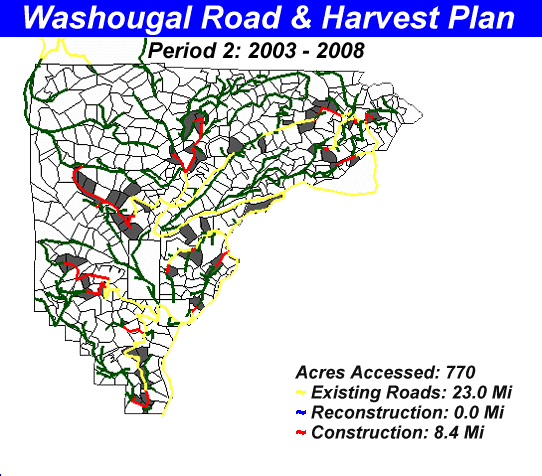 Figure 14.2 Road and Harvest Schedule based on SNAP analysis, 2003-2008, 4,000 MBF/year
Period 2, 2003 - 2008
In the second period, 8.4 miles of new road is constructed. The bulk of the construction extends the existing roads, building further up into Mine Creek and the Upper Washougal areas. In this period SNAP also chooses to haul timber over the Forest Service land to the North. With the exception of the 502 road to the West the majority of the Forest Service roads are accessible and would require little reconstruction. Fortunately, the 502 road is not necessary to access timber in the Washougal.
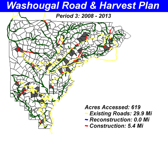 Figure 14.3 Road and Harvest Schedule based on SNAP analysis, 2008-2013, 4,000 MBF/year
Period 3, 2008 - 2013
The third period, (fig road3), SNAP begins to minimize road construction. Since the annual harvest volume is set at 4 million board feet a year, road construction costs become a larger portion of the harvest costs. In the third period SNAP only constructs 5.4 miles of road. SNAP also continues to haul out through the Forest Service land to the North.
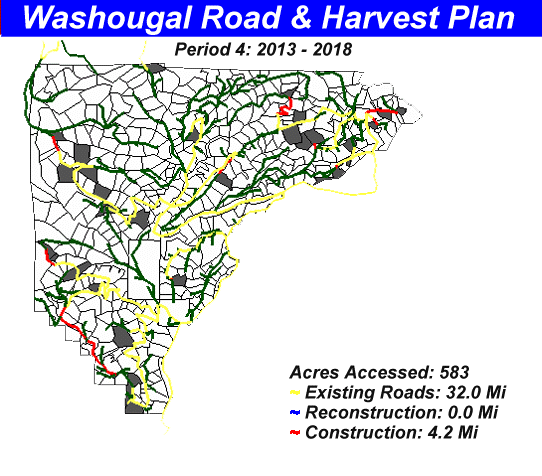 Figure 14.4 Road and Harvest Schedule based on SNAP analysis, 2013-2018, 4,000 MBF/year
Period 4, 2013 - 2018
In the 4th period SNAP follows the same trend, reducing road construction and harvest acreage. SNAP makes some interesting decisions in this period. In the Southwestern part of the Miller Gate area, major construction occurs on the MG mainline. In this period no timber is hauled over this new road. Since SNAP builds so few roads this period, it may be trying to spread out construction costs over the entire planning period.
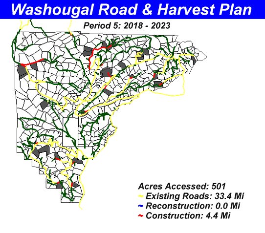 Figure 14.5 Road and Harvest Schedule based on SNAP analysis, 2018-2023, 4,000 MBF/year
Period 5, 2018 - 2023
In the last two periods SNAP continues to decrease road construction costs and harvests less acreage due to increased volume per acre. Between 2013 and 2023 harvest units are located throughout the watershed. With the exception of spur roads almost no roads are abandoned in the Washougal watershed. With no flat ground, roads are forced onto the ridge tops where they must remain open to access other units. Road abandonment will be a very minor part of managing the watershed.
In this last period SNAP decides to harvest a unit along the MG road that was constructed last period. SNAP also decides to build some more roads along the northern edge of the watershed accessing the upper Grouse Creek and Upper Washougal areas from the w-2070. In our planning period, SNAP never decides to build the roads up the Washougal river from the w-2070. Because of the enormous cost of building three bridges to access the timber up there it will most likely never be built.
Road Densities |
Road densities in the watershed over time are relatively low. The maximum road density in the watershed would be 4.16 miles / section. This is assuming that no roads are abandoned and that all of the proposed roads are built. Table 14.4 shows the road density in the watershed per 5-year period.
Table 14.4 Road Construction Schedule and Road Densities from the SNAP Analysis
|
Period # |
New Construction |
Total Road |
Road Density |
Road Density |
|
Miles |
Miles |
Miles / Section |
Stations / Section |
|
|
Current Condition |
11.5 |
11.5 |
0.59 |
31.11 |
|
Period 1 |
10.4 |
21.9 |
1.12 |
59.24 |
|
Period 2 |
8.4 |
30.3 |
1.55 |
81.96 |
|
Period 3 |
5.4 |
35.7 |
1.83 |
96.57 |
|
Period 4 |
4.2 |
39.9 |
2.04 |
107.93 |
|
Period 5 |
4.4 |
44.3 |
2.27 |
119.83 |
|
Proposed Roads |
36.95 |
81.25 |
4.16 |
219.77 |
Harvest Volumes |
Using the growth rates input into SNAP the volume per acre increases over time. The initial volumes put into SNAP were 16 MBF on the poor sites and 23 MBF on the better sites. As the graph below shows (figure 14.6), the volumes at the end of our 25 year planning horizon are around 40 MBF.
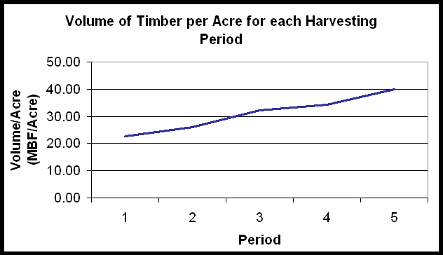 Figure 14.6; Average Timber Volume per Acre over the Planning Period
SNAP Costing |
The costs in table cost are from the SNAP analysis. An annual inflation rate of 3% is assumed for all costs. The mill price of the wood is assumed to grow at 3.5%, just above the inflation rate. Therefore, the costs and prices in period 5 are 2020 dollars, the middle year of the period. The first period costs are in year 2000 dollars. Construction costs for the Washougal are relatively high. A typical $/MBF for the West Cascades is about $40. In the Washougal we are seeing $70/MBF in the first period. The reason for the high cost in the first period is the amount of road that is constructed, 10.4 miles. The harvest, haul and mill prices are close to current prices, resulting in a stumpage $/MBF that is only slightly lower than the DNR statewide average for 1998.
Table 14.5. Harvest Costs and Revenue by Period form SNAP
|
Period |
Volume |
Construction |
Harvest |
Haul |
Total |
Mill Price |
Stumpage |
|
MBF |
$/MBF |
$/MBF |
$/MBF |
$/MBF |
$/MBF |
$/MBF |
|
|
Period 1 |
19993 |
$70.14 |
$112.19 |
$40.61 |
$222.94 |
$626.64 |
$403.70 |
|
Period 2 |
19998 |
$62.37 |
$128.45 |
$49.98 |
$240.79 |
$744.25 |
$503.46 |
|
Period 3 |
19988 |
$47.07 |
$152.37 |
$58.14 |
$257.58 |
$883.94 |
$626.36 |
|
Period 4 |
19991 |
$43.58 |
$181.45 |
$70.50 |
$295.53 |
$1,049.84 |
$754.31 |
|
Period 5 |
19998 |
$54.91 |
$206.50 |
$84.02 |
$345.43 |
$1,246.88 |
$901.45 |
Management of the Watershed |
The following chart shows the percentage of the watershed that is being managed over time. This 25-year plan manages less than 1/3rd of the watershed. The currently managed portion of the watershed is the clear-cut setting at the end of the w-2050.
Table 14.6; Percentage of the Watershed under Management
|
Managed Acres |
Management |
Total Management |
|
|
Period # |
by period |
by period |
of the Watershed |
|
Current Condition |
58 |
0.50% |
0.50% |
|
Period 1 |
880 |
7% |
7% |
|
Period 2 |
770 |
6% |
13% |
|
Period 3 |
619 |
5% |
18% |
|
Period 4 |
583 |
5% |
23% |
|
Period 5 |
501 |
4% |
27% |
Habitat in the Washougal |
In order to comply with the HCP habitat constraints were set. The harvest schedule outlined above maintains habitat in the watershed over the planning period and beyond. Long term analysis indicates that habitat can be maintained in the watershed while sustaining a harvest of 4 million board feet per year.
To define habitat in the watershed using SNAP we had to come up with a seral stage or group of seral stages that represented habitat. Using LMS, a more sophisticated growth-modeling program, we were able to define habitat for SNAP. For the Washougal we assumed that any unmanaged stand older than 55 years would be considered habitat, and we assumed that all riparian areas would be habitat within 5 years. For the Washougal this means that nearly all of the dispersal habitat area will be habitat in the next five to ten years.
To make the 55% habitat requirement a constraint in SNAP we told SNAP that at any one time no more than 45% of the dispersal area could not be habitat. We then ran SNAP in 25 and 100-year cycles to determine the maximum sustainable volume that could be harvested from the watershed while still maintaining habitat. According to the SNAP analysis a maximum of 4 million board feet a year can be harvested from the watershed while maintaining HCP requirements. The graph below (figure 14.7) shows an increase in habitat over the next 10 years and then a decline. Forty five years from now as habitat in the watershed declines towards 50%, replanted stands begin to come back into habitat. The figures below show habitat in the watershed over the next 25 years.
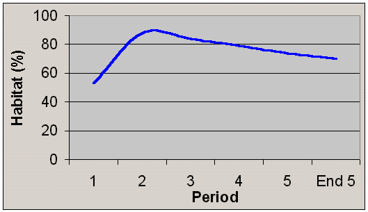 Figure 14.7; Percent habitat in the Washougal for each time period in our analysis
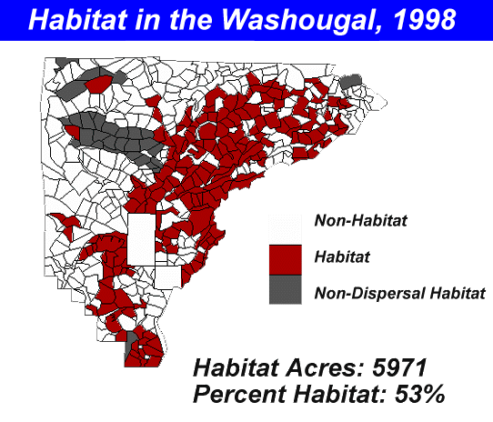 Figure 14.8; HCP Dispersal Habitat in the Washougal watershed, 1998
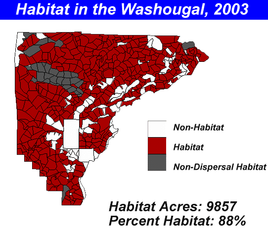 Figure 14.9; HCP Dispersal Habitat in the Washougal watershed, 2003
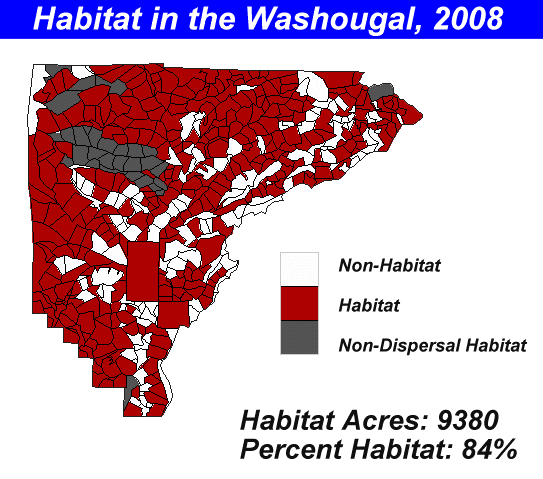 Figure 14.10; HCP Dispersal Habitat in the Washougal watershed, 2008
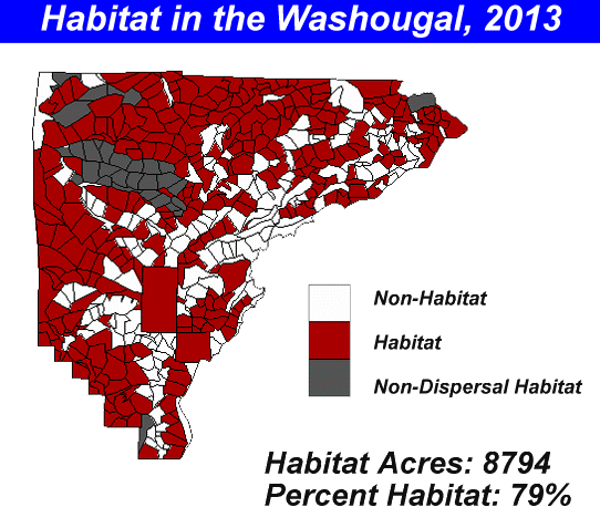 Figure 14.11; HCP Dispersal Habitat in the Washougal watershed, 2013
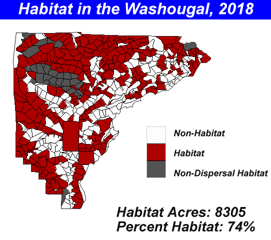 Figure 14.12; HCP Dispersal Habitat in the Washougal watershed, 2018
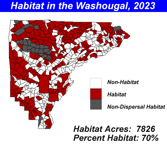 Figure 14.13; HCP Dispersal Habitat in the Washougal watershed, 2023
Final Recommendations |
Based on the SNAP analysis, a sustainable harvest of 4 million board feet a year while maintaining habitat is possible. Some reasonable assumptions were made to help with our analysis like initial volumes, growth rates and harvest costs. Ideally, better timber data and growth rates would have been used in our analysis. Even though the volumes and growth rates may not accurately reflect the conditions in the watershed, the road construction and harvest scheduling is valuable. With adjacency and habitat constraints, SNAP did an excellent job of scheduling the management actions in the watershed. Hopefully, when better FRIS data becomes available, this analysis can be revisited.
The two primary goals of our watershed management plan were to 1) comply with the HCP and create or maintain habitat in the watershed indefinitely, and 2) provide Skamania County stakeholders with the maximum fiscal return possible. The plan outlined above provides for both of these constraints. By harvesting 4 million board feet a year and maintaining habitat we are providing the residents of Skamania County a sound harvest schedule.
The SNAP and LMS analysis show that partial cutting and thinning are of no benefit in creating habitat. The SNAP and LMS analysis have shown that there are currently no management actions that will create habitat in the Washougal within the next twenty years. An LMS analysis shows that the stands do not respond to thinning which partially explains why SNAP only thins two units over the planning period. In the two units that are thinned, SNAP most likely overestimates the value of the timber coming out of those units. SNAP thins by removing 40% of the volume in a stand with no regard to the size of the trees it is harvesting. If anything, SNAP overestimates the value of these thinnings since it does not "thin from below". The most economical method of harvesting timber in the Washougal is clear-cutting.
Possibly the best way to create habitat in the watershed would be to clear-cut the units and start with nursery trees, fertilization, pre-commercial thins and commercial thins. Our predictions indicate that within five to ten years 85% of the watershed will be habitat. This may be an overly optimistic view on the future habitat conditions of the area but it does indicate that forest management practices can be implemented immediately in areas that are not currently habitat.
Future Analysis
As FRIS data becomes available for the Washougal, this analysis of the watershed should be revisited. Reliable timber data would greatly increase the reliability and accuracy of our analysis. However, the analysis we performed was based on reasonable assumptions and methods. We are confident that our analysis can provide a foundation for future management practices in the Washougal. One thing about the Washougal is certain, long term planning is an absolute necessity to provide habitat under the HCP rules and maintain a high rate of return to the Skamania trust.