8 Preliminary Setting Design Process

8.1 Plans

Preliminary Logging Analysis System (PLANS) is a software package developed by the United States Forest Service (USFS) in the early 1980’s. It was used as a tool for locating and designing skyline harvest units within the Hoodsport planning area. In order for PLANS to fit skyline designs to a specified terrain, Digital Terrain Models (DTM) are used to provide the necessary topographic data. Within PLANS, there are two integrated programs, SKYTOWER and SKYMOBILE. SKYTOWER determines payloads and spans for towers operating from large central landings. SKYMOBILE is used for mobile yarders operating in parallel settings and analyzes single profiles versus multiple radiant profiles (maximum of 18) used by SKYTOWER.

8.2 Design Inputs

8.2.1 Yarder and Carriage Information

Before beginning PLANS, information pertaining to yarding equipment must be obtained in order for PLANS to calculate payloads and deflections for further analysis of skyline profiles. Both SKYTOWER and SKYMOBILE require the following yarder equipment specifications:

  • Maximum slope rigging distance (ft)
  • Desired payload (lb.)
  • Minimum required ground clearance (ft)
  • Carriage height when logs fly clear (ft)
  • Carriage weight (lb.)
  • Tower height (ft)
  • Tailhold height (ft)
  • Allowable skyline tension (lb.)
  • Skyline weight (lb./ft)
  • Mainline weight (lb./ft)

A complete list of yarding equipment specifications can be found in Appendix XXX.

8.2.2 Identification of Potential Landing Sites

The identification of potential landing sites was based solely upon breaks in terrain as identified off of topographic maps for the Hoodsport planning area. These breaks in terrain where areas that would adequately meet the requirements for a yarder, whether it be a swing or tower type of yarder. Areas were also looked at for feasibility of long span yarding versus conventional short span yarding.

8.3 Design Outputs

The purpose of the PLANS analysis is to determine the feasibility of cable yarding at various landing locations. The output from the PLANS analysis includes landing locations, cable road profiles, tailhold heights, and payloads. A conventional analysis and a separate alternative analysis were performed. These analyses are discussed below.

8.3.1 Conventional Analysis

The idea behind the conventional PLANS analysis is to provide complete, overlapping coverage of the planning area. This means that every section of ground on the map that is suitable for cable yarding should have at least one profile covering it. Landings should be selected in such a way that this full coverage is achieved while maintaining the required payload and without exceeding the maximum tailhold height for the timber in the relevant stand. Figure 35 shows a group of landings and profiles typical of the conventional PLANS analysis.


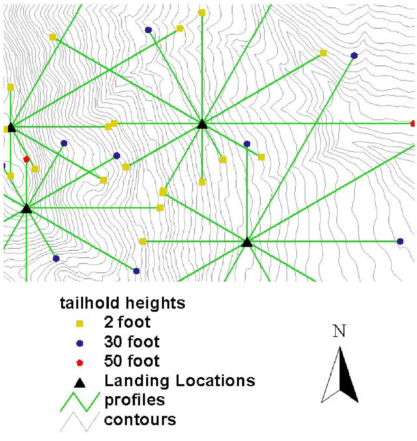
Figure 35. A typical group of landings, profiles, and tailhold heights from the conventional PLANS analysis. Notice how the profiles meet in the middle, with slight overlap where possible.

In order to achieve full coverage of the planning area, approximately 150 tower landings and 30 swing landings were analyzed. Additional swing landings were used in areas where the feasibility was not in question. In all, approximately 100 swing landings and 150 tower landings were required to cover all of the cable yarding ground in the planning area. In most cases, profiles were analyzed for a payload of 5000 lbs. In some cases, payload was sacrificed in order to obtain a longer profile, but the payload always exceeds the potential load. Tailholds varied between 2, 30, and 50 feet depending upon the need and the availability of tail trees. Profiles extended as far as 2000 feet where possible. Average profile lengths were closer to 1000 feet.

These results from the conventional PLANS analysis are used in the preliminary road design process (Chapter 9), and later in the creation of final setting systems (Chapter 10).

8.3.2 Alternative Analysis

An alternative PLANS analysis was performed to examine the potential of longspan yarding systems in the Hoodsport planning area. Longspan systems are characterized by long, parallel profiles, more powerful yarders, and more logs per turn. Due to the addition of an extra log per turn, the design payload was increased to 6500 lbs. per turn. Twenty-three longspan profiles were analyzed with an average AYD of 1250 feet (ranging from 708 feet to 1850 feet). This corresponds to external yarding distances (EYD) of up to 4000 feet. These preliminary longspan profiles are used later in the final alternative analysis, discussed in Chapter 12.

Back | Cover Page | Table of Contents | Next