1 Executive Summary

1.1 Project Expectations / Results

During the Spring of 1999, the senior class of Forest Engineering undergraduates of the University of Washington, under the direction of Dr. Peter Schiess, developed a harvest plan for 10,000 acres of the North portion of the Hoodsport planning area (T24N R03W, WM, north of the Jorsted Road. After months of preparation and three weeks of fieldwork, a final report and presentation were submitted to interested officials of the Department of Natural Resources in June of 1999. Several expectations were included in the plan of operations for the Hoodsport project. Below is a list of expectations and the UW’s level of fulfillment of these expectations.

Expectation: 10 year management and transportation schedule.
Result: 25 year management and transportation schedule.

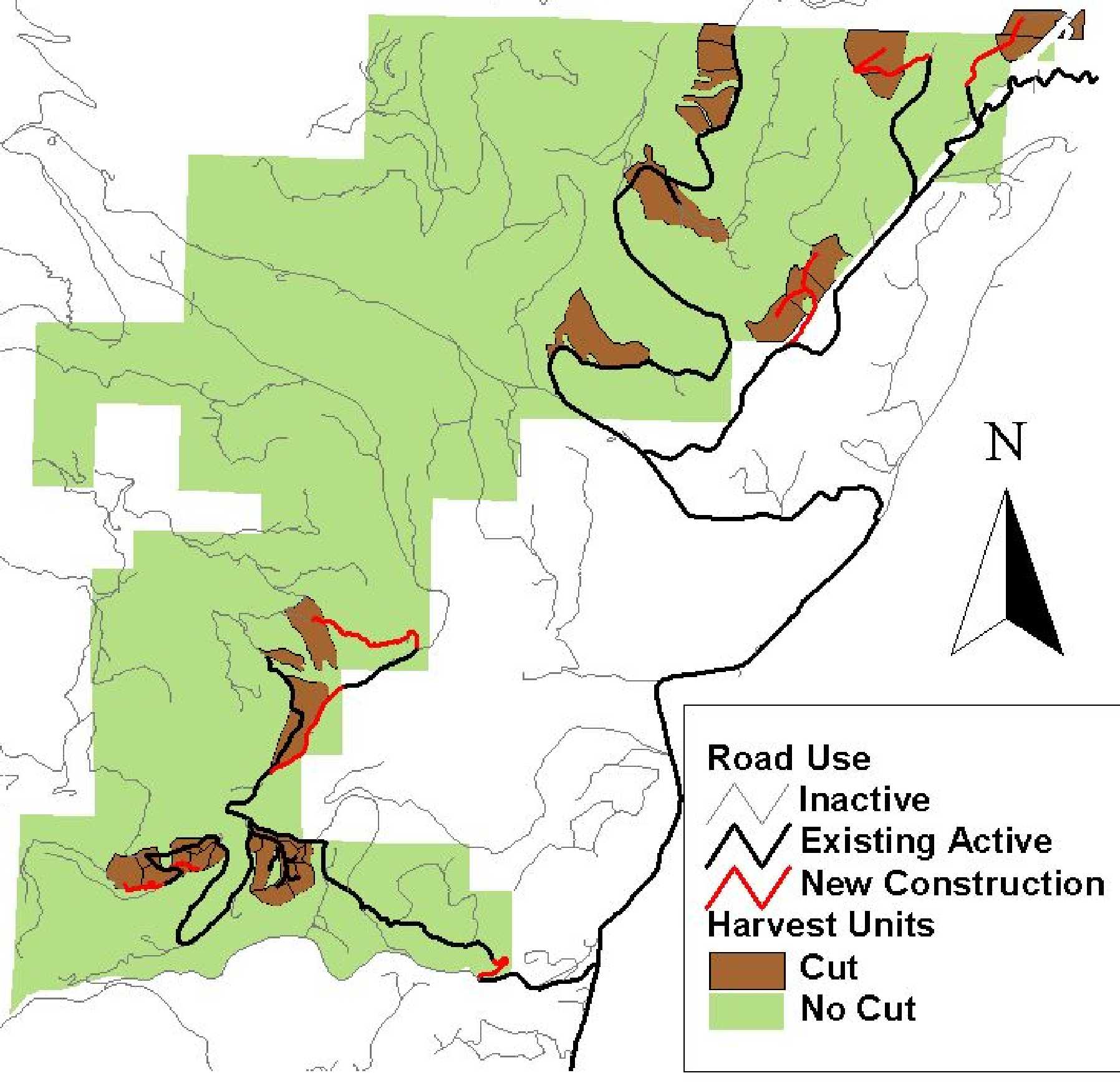
Expectation: Road Management Strategy
Result: Road use patterns were developed over a 25-year span. The analysis included trade-off of road closures-road maintenance issues. Beyond the original scope a detailed sediment budget was prepared that could be used for road maintenance and closure decisions to minimize salmonid habitat degradation.

Expectation: 1000 acres of alternative yarding analysis.
Result: 1300 acres were analyzed using helicopter and long span yarding as alternatives.

Expectation: 2.8 miles of detailed road design.
Result: 5 miles of detailed road design, including two bypasses of existing slides.

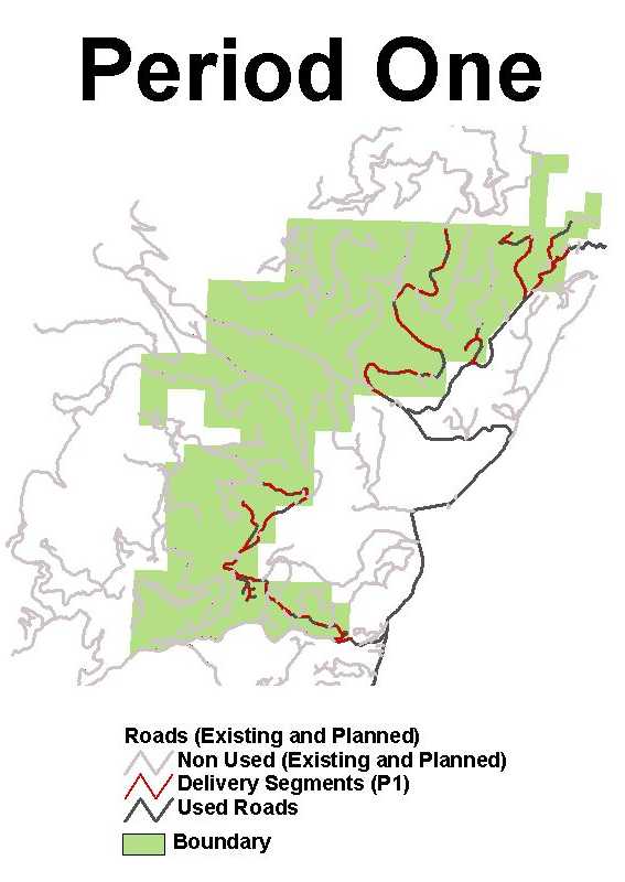
Expectation: Project Report and Maps
Result: A landscape management plan and a transportation plan for the North Hoodsport Block were created. Map deliverables include a set of base maps and SNAP input and output maps, along with all of the working maps used throughout the project.

Expectation: Leave-tree strategy
Result: A leave-tree strategy was formulated that combined biological/silvicultural design parameters with skyline setting design parameters. The strategy was applied to a proposed sale to demonstrate its use.

1.2 25 Year Management and Transportation Schedule

A 25-year management and transportation plan was created using SNAP, a Scheduling and Network Analysis Program. The DNR 5-year action plan was incorporated into the first 5-year period of the final plan. Volume goals for each 5-year period were met, despite the reemergence of Spotted Owl circles. The timber inventory also increased every year, suggesting continued revenue production into the more distant future.

Figure 1. Road and harvest schedule based on SNAP analysis, 1999-2004. A total of 730 acres is being managed in the 5-year period with 20.7 MMBF of timber being harvested. To access the proposed sales and in preparation of future management activities a total of 4.6 miles of new road construction is being planned.

1.3 Road Management Strategies

Road density is a commonly used measure of the environmental impact caused by road systems. One of the major environmental impacts of road systems is the increased level of sediment yielded to the stream network. Through our assessment of the sedimentary impact of roads in the Hoodsport planning area, we have determined that road density is not an accurate indicator of sediment yield to the stream network. The location of roads and the number of stream crossings are better indicators of sediment yield, and thus provide a more accurate evaluation of the environmental impact caused by roads.

Road segments that contribute to sediment loading are identified. In all, traffic-induced sediment delivery is about 10 percent of background sediment delivery to the stream network in the planning area.

Figure 2. Roads used for truck haul during period one of the SNAP results. Roads that are used are shown in black with road segments that deliver sediment to the stream system shown in red.


1.4 Alternative Analysis

The alternative analysis compared helicopter and long span yarding systems with conventional systems. The helicopter analysis was conducted by inputting alternatives into SNAP. It was determined that it is not appropriate to perform a long span analysis on a sale by sale basis. Long span analyses must be done at the landscape or watershed level based on the nature of long span settings. In all, 800 acres were evaluated for the helicopter alternative, and 500 acres were analyzed for the long span alternative for a total of 1300 acres.

Figure 3. View of Five-Flag Timber Sale with dispersed retention of 8tpa. This unit was evaluated as part of the alternative harvest system (long-span) design. Various leave tree strategies were explored.

1.5 Detailed Road Designs

Approximately 5 miles of road were fully designed using ROADENG, a road design program. These designs were included in the transportation report and include notes for stationing, grade, side slopes, cut and fill volumes, horizontal and vertical offsets, and slope staking.

Two roads were designed to bypass the Jorsted Road slide and the Wes Road bridge failures. These bypass roads are located in more stable locations than the existing roads and will cost less to construct than the existing roads would cost to reconstruct.


Back | Cover Page | Table of Contents | Next