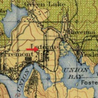
Land classification map of U district area in 1897
Dublin Core
Title
Land classification map of U district area in 1897
Subject
Land classification sheet, Washington, Seattle, 1:125,000 topographic quadrangles
Description
The arrow shows where Block44 is, which is a timber cut area with no restocking planned(yellow). The northeast area is also deforested but in process of restocking (green).
Creator
U.S. Geological Survey.
Publisher
Washington, D.C. : The Survey
Date
1900
Contributor
University of Washington Libraries Map Collection
Rights
This image may be freely downloaded and used.
Type
Topographic Maps
Files
Citation
U.S. Geological Survey. , “Land classification map of U district area in 1897,” University District Stories, accessed February 25, 2026, https://courses.washington.edu/hstaa208/items/show/404.

