


|
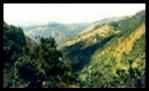
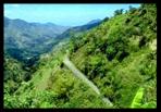
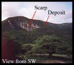
Jamaica’s highest elevation is that of the Blue Mountains, with its mountaintop the Blue Mountain Peak being the highest, which measures at 2, 256 meters. This stretch of mountains is located in the parishes of St. Andrew, St. Thomas, Portland and St. Mary. (Fig B) (Wikipedia 2007) The Department of Botany from the Smithsonian tells us that; “The Blue Mountains have a complex geology of both volcanic and marine influences. The rocks are igneous and sedimentary of origin with the soils being mainly siliceous.” They also state that the Blue Mountains are formed by, “a central ridge of metamorphic rock that runs northwest to southeast, from which many long spurs overhang to the north and south, for a distance of over 3 kilometers, the crest of the ridge exceeds 1,800 meters.” (Smithsonian) The John Crow Mountains are the opposite, the Smithsonian states, “they are comprised of white limestone, marine sandstones and shale." Smithsonian) It’s coordinates are located between the Latitudes 17°57'-18°12'N and longitudes 76°49'-76°16'W. This also includes the John Crow Mountains and the surrounding area of “crown land.” (Wikipedia 2007) In 1990 both the Blue and John Crow mountains were preserved and celebrated as Jamaica’s first national park. Here the Nature Conservatory tells us that, “This protects one-third of approximately 30% of Jamaica that is still under natural forest cover.” They also say that, “it is the largest reaming tract of intact, closed canopy broadleaf forest left in Jamaica.” (Nature Conservatory 2007). The Eastern part of Jamaica’s topography is steep and rugged. The landscape is geologically stated as, “being young (Quaternary.)” This part of the island is the most seismic and suggest to be undergoing geotectonic uplift. The watersheds that we mention earlier are steep, weak and small. (Ahmad 1998) Landslides are common in Jamaica and is widespread throughout the country. The University of the West Indies states, “ they are perhaps the most widespread hydrogeologic causing land degradation thus affecting land productivity.” They also go on to say, “Landslides preferentially occur in locations such as Judgment Cliff where the direction of dip of bedding in the shale and sandstone sequence daylights in slope faces.” Pictures on left show topographical and scarp deposits of Judgement Cliff. (Ahmad 1998) |
|
Blue Mountains |
|
Web Page Research & Design Minnha Tran and Paris Rogers |
|
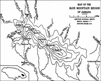
Fig B. |
|
Land of Wood and Water |
|
This is the contour map of the Blue Mountain Region where contour intervals are 500 ft. |


|
Pictures from Nature Conservatory of Jamaica and Geology Dept Smithsonian |
|
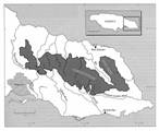
Map 34. Blue and John Crow Mountains, Jamaica |