|
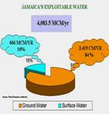
Jamaica has a landscape that is mountainous with lots of rivers and tributaries, so because of these reasons, Jamaica has watershed characteristics. (Wikipedia 2007) What this means by Wikipeda’s definition is that, “a large part of the island delivers run-off water inland sediment and carries dissolved substances to a river.” They also go on to say that, “Watersheds is that part of land linked to its water source and 26 watershed management units within the land that consists of over 100 streams and rivers.” (Wikipedia 2007) There is a way that water is processed and used to transfer moisture from the earths atmosphere by evaporation of water and transpiration of plant called evapotranspiration. This is considered a result of total water balance. (Wikipedia 2007) The Water Resource Authority of Jamaica tells us that, “total water balance is calculated as a sum of evapotranspiration losses, surface water runoff and ground water discharge.” They go on to say, “important numbers are the so-called ‘exploitable’ water resources.” Here they tell us the yield for total surface runoff for the country is, “estimated at 12% of the total surface water runoff, making the volume equal to 666 MCM/yr.” (See fig A) (Water Resource Authority) The graph on the left (fig A) shows the, “safe yield of ground water,” which is, “estimated at 3,419 MCM/yr.” WRA suggests that, “the ground water component is about 84% of the total available water, and surface water component the remaining 16%.” They say, “This is one of the important factors of usable water resources.” They also tell us that in the year 2015,it is projected that agriculture will be the biggest consumer of water. (Water Resource Authority) Lloyd says the same thing and states," Based on the use of water in the past, agriculture utilizes a high percentage of water in Jamaica. In 1980's, 75% of the water is used on agriculture and is predicting to increase to 79% by 2015.” (Lloyd 2004) During Jamaica’s average annual rainfall, Ellin tells us that, “56% of water is lost because of the evapotraspiration process and 20% are lost due to limestone aquifer developed through wells.” Ellin suggests that, “mostly in the Rio Cobre and Rio Minho water body, the water is generally available as base flow and is utilized through run-of-river progress.”(Ellin,1992) The Water Resources Development Master Plan concluded that, “The total use of water will be increase from 21% in 1980 to 41% in 2015 of the total available water. (Llyod 2004) What these percentages tell us is that Jamaica is losing over half its water source due to evapotraspirtation and their agriculture is increasing water usage. |


|
Fig A |
|
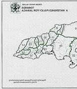
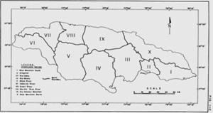
Watershed Locations Ministry of Agriculture Jamaica |
|
Graph by WRA |
|
This map shows a Hydrogeological Unit, which refers to an area drained by surface water and/or Groundwater system. The Boundaries suggest that there is no flow from one Basin to the next and WRA shows us, “ The Island Is Divided Into Ten (10) Hydrological Basin. The Basin Boundaries Are The Main Surface Water Divides, But In Some Cases Groundwater Divides Have Been Used For The Basin Division.” (WRA) |
|
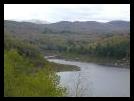
Pictures from the Nature Conservatory |