

|
Coastlines, Coral Reefs, and Bauxite |

|
Web Page Research & Design Minnha Tran and Paris Rogers |
|
Land of Wood and Water |
|
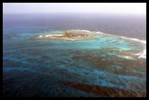
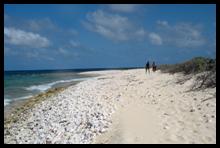
The coastline of Jamaica is one with many variances, for instance Wikipedia tells us, “the northeast shore is severely eroded by the ocean. There are many small inlets in the rugged coastline, but no coastal plain of any extent. A narrow strip of plains along the northern coast offers calm seas and white sand beaches. Behind the beaches is a flat raised plain of uplifted coral reef.”(Wikipedia) Wikipeidia describes the southern coast as, “as small stretches of plains lined by black sand beaches, which are backed by cliffs of limestone where the plateaus end.” In many areas of Jamaica where there is no coastal plain, Wikipedia tells us that “the cliffs drop 300 meters straight to the sea and in the southwest, broad plains stretch inland for a number of kilometers. The Black River courses seventy kilometers through the largest of these plains.” Also in the plains are swamplands of the Great Morass and the Upper Morass. Then the western coastline is the area of the finest beaches of Jamaica. Wikipeidia tells us that it stretches," for more than six-hundred kilometers along a sandbar at Negril.” (Wikipedia) Jamaica’s Coral Reef is named Pedro Bank which was once known as “La Vibora,” this means the viper. This was once a busy and dangerous shipping passage used by Europeans in the sixteenth and seventeenth century. It was named this because of the giant serpent shape the landscape that consists of shallow reefs, rocks and shoals. Zenny tells us that, “Archaeologists estimate that there are over 300 shipwrecks on the Bank.” It’s main importance is harvesting ground Queen Conch. (Zenny 2004) Bauxite mining is a major economic activity in Jamaica, which has led to foreign controlling interests of about 10% of the land. (Lyew-Ayee and Steward, 1982) The Bauxite processing plant is located at Latitude: 17°44’ 21 42° 14’ N and Longitude: 77°10’45.23°W. Jamaica is the, “net exporter of mineral products and its mining provides about 10% of the GDP of the country. Bauxite deposits cover over 20% of Jamaica’s land surface.” (Lyew-Ayee and Stewart, 1982) These deposits mostly occur as, “infillings in between the irregular shaped karst depressions. After open pit mining, bauxite lands are reshaped with an abundance of topsoil, and revegetated with grass. This results in steeper shallows and higher in limestone rock fragments that pre-mined soils.” (Lyew-Ayee and Stewart, 1982) There is a national mineral policy in place which is aimed at ensuring a sustainable mineral sector and demands among other things that once minerals have been removed from the earth, the soil must be replaced and trees planted, but still these positive actions disturbance of the land area being mined still contributes to land degradation. (NAP 2004) |
|
Coral Reef and the Coastline of Jamaica |
|
Photos from the Nature Conservatory |
|
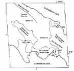
Mineral Locations In Jamaica |