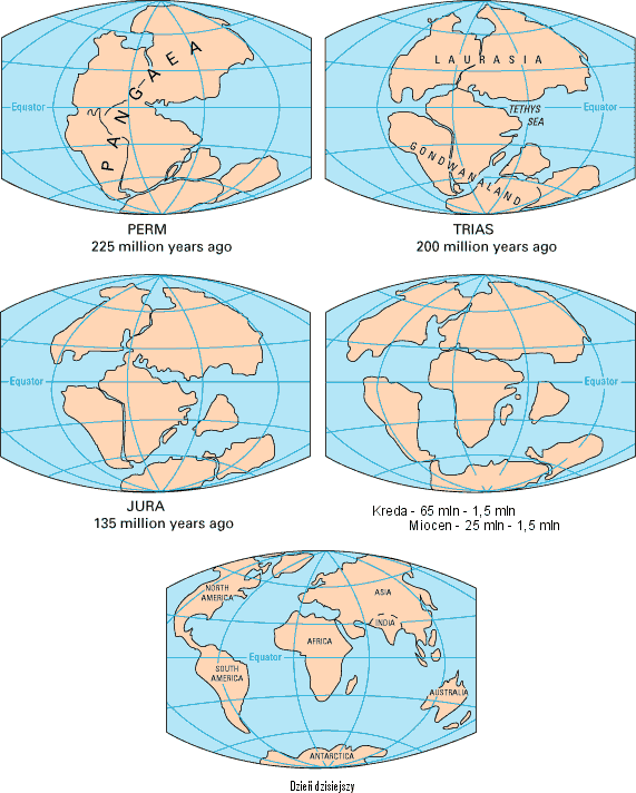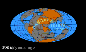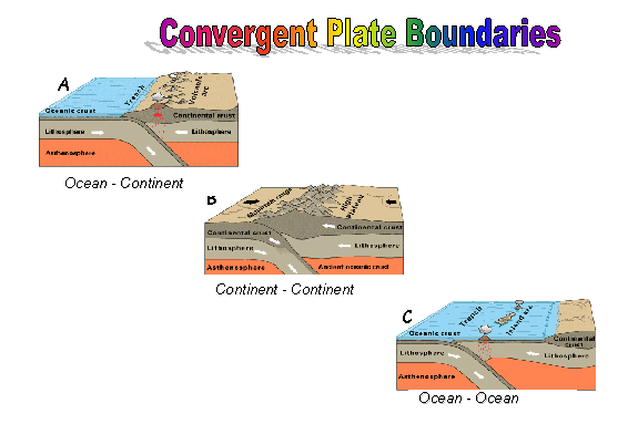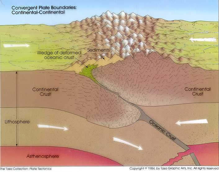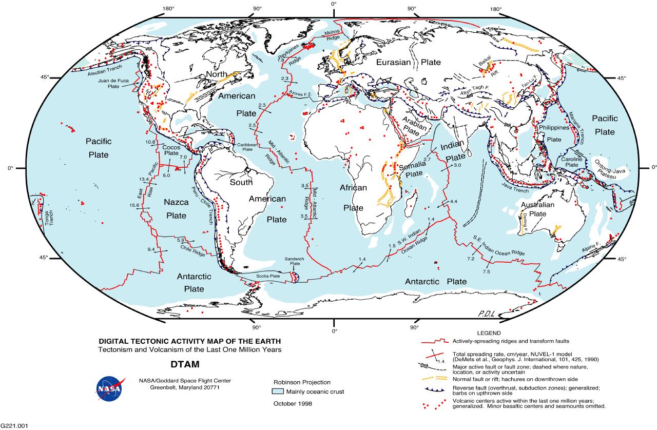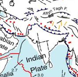


Formation and Plate Tectonics
The
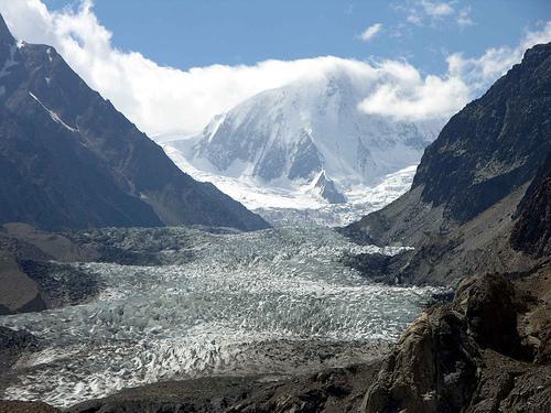
Mountains
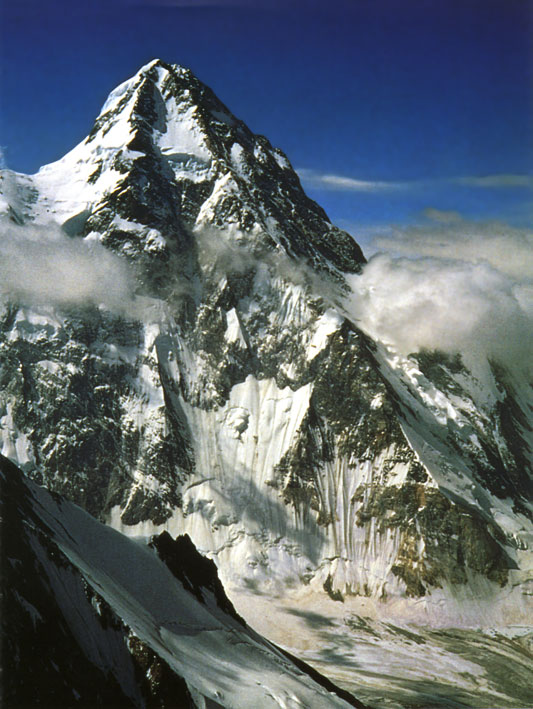
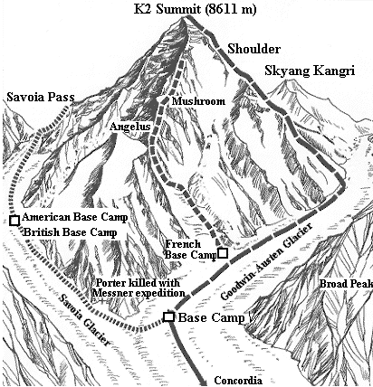
Within the Karakoram Mountain Range lies a sub range known as the Baltoro-Muztagh. This is home to the world's second largest mountain as it is over 8.6 km tall, which is just shy of
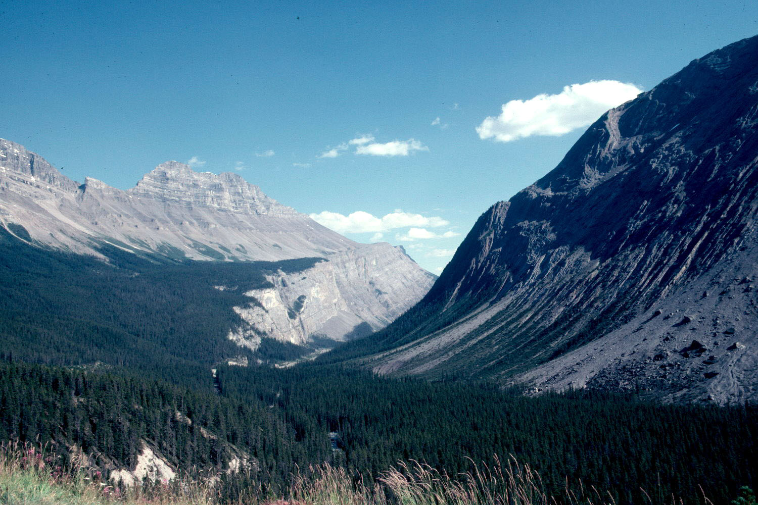
Glaciers and Valleys
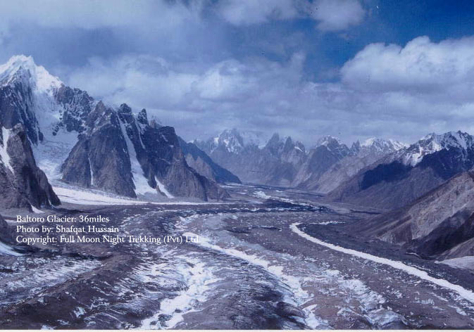
One process that still continues to create geomorphologic change is the formation of glaciers. These features have greatly impacted the landscape of the
Glacier Expansion
An interesting occurrence that contrasts widespread evidence of glacier decline is that of glacial expansion in the central Karakoram region. Apparently this expansion only effects the glaciers that are sized over 7000m and are in elevations of 4500m in this region (Hewitt 2005). Although limited studies have been conducted to research this phenomenon, one major factor that has attributed to this is the change and effects of decreased temperatures. It has been found that in this specific region, there has been a drop in spring and summer temperature. This is highly contradictory to the weather conditions in east the
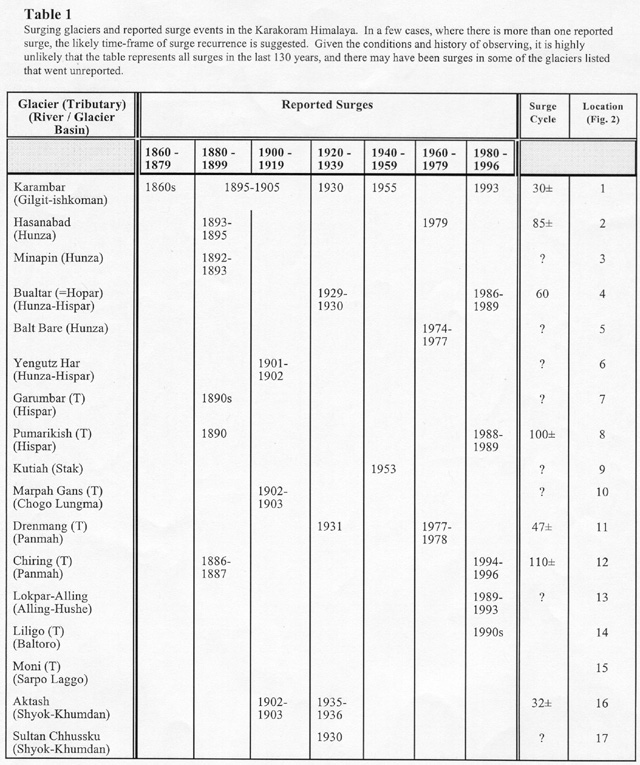
The evidence for glacier expansion has primarily been found with 8 particular glaciers in the region that have displayed a renewed lateral moraine building. This moraine building exhibits thicker and more active ice, which has overridden moraines that were virtually ice free for the past 50 years (Hewitt 1998b). Although this thickening has been irregular in its occurrence, it has developed quickly where there had previously been thinning and recession according to studies conducted from 1985 to 1995 (Hewitt 1998a). Important ground observations that have clearly defined glacier expansion include, but are not limited to: A defined line that distinguishes active ice and passive margin; fresh ridges of lateral moraine next to the line of shear; and continuous sections of ice cliff that has risen past the glacier surface and surpassed overhanging glacier margins. In the past, features like this were rarely seen, but when they were observed, it was credited to Ice Age expansion. Now that they have become more commonplace, more research has found that climate and temperature change is the leading theory for such surges (Hewitt 2005). Table 1 to the list show a record of years that glacial surges have been reported as well as if there is a surge cycle associated with them. As the table reveals, the frequency of data is not sufficient to determine how often glacial surges occur. Ongoing research has not been established to provide such results.
Effects of Climate/Temperature
With a geographical location of roughly 36°N and 74°E, the region in which the
In the past, suggested theories of glacier expansion in the Karakoram region were thought to be a varying response to climate change, especially with regard to large influxes of monsoon snowfall (Kick 1989). But more recent research suggests that regional climate, seasonality, and recent climate change may all attribute to glacier expansion (Hewitt 2005). Climate studies have also shown 3 distinct weather systems that have had an impact on this region. There is a westerly circulation and cyclonic storms in the winter, an accumulation of heavy snow in the high-altitude also during the winter months, and monsoon advancement in the summer months. These monsoon storms produce cooler temperatures as well as additional snowfall (Kick 1989). Since increased precipitation creates cloudy skies, the net radiation that would normally be responsibly for 80 to 85% of glacier ablation creates another factor in why glacier expansion might be sustained. With an increase in winter precipitation and a decline in summer mean and minimum temperatures, there is substantial evidence that these factors in climate change correlate with the positive mass balance in glaciers (Fowler and Archer 2006).
Since glacier mass balance is determined by the accumulation of snow on top of the glacier and the ice ablation on the bottom, research has found that the glaciers that have gained the most mass have been nourished by avalanched snow in addition to increased precipitation. Also, some glaciers have steep high rock walls or heavy moraine, which act to reduce ablation by trapping snow (Hewitt 2005).
Decreased Watershed and Its Effects
A problem that has been created by the sudden glacier expansion is the impact it has on those glaciers in the high latitudes that previously had the highest watersheds. Reduced flows have been reported for rivers dominated by glacier runoff draining the highest parts of the
Landslides Another problem that has been identified in the Karakoram region with regard to river flow is the catastrophic effects that landslides have on the
Climatic and temperature drops continues to be a problem for the Karakoram Mountain region, as the change in these trends are causing geographical problems that cannot continue to be ignored. As stated before, there is an absence of ongoing research in this area due to its difficult location and the high costs associated with that. Because research has not been continuous, many disputes have developed that have formed discrepancies on the information concerning the actual amount of avalanches that have occurred as well as the theories surrounding why glacier expansion continues to be a phenomenon. Without ongoing research, it has and will continue to be very difficult to identify other factors that may attribute to glacier expansion as well as pinpoint other elements that could possibly explain the influences of glacial behavior.
Another problem that has been identified in the Karakoram region with regard to river flow is the catastrophic effects that landslides have on the
Climatic and temperature drops continues to be a problem for the Karakoram Mountain region, as the change in these trends are causing geographical problems that cannot continue to be ignored. As stated before, there is an absence of ongoing research in this area due to its difficult location and the high costs associated with that. Because research has not been continuous, many disputes have developed that have formed discrepancies on the information concerning the actual amount of avalanches that have occurred as well as the theories surrounding why glacier expansion continues to be a phenomenon. Without ongoing research, it has and will continue to be very difficult to identify other factors that may attribute to glacier expansion as well as pinpoint other elements that could possibly explain the influences of glacial behavior.