Norway
Geography of the Physical Environment
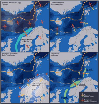
Norway is located on the Eurasian Plate (NORSAR 2007). It is notable that its location on this plate is close to the plate boundary with the mid-Atlantic Ridge where sea-floor spreading causes "ridge-push" stress. The build up of stress along this margin is the primary cause of earthquake activity affecting Norway (UiB 2005).
The backbone of Norway which runs through North to South along the coastline is made up of the Caledonides Mountain Range. This range is known for its height and contributes to the large amount of elevation changes from Norway's west coast and heading inland. It is likely that the Caledonides are part of the same range of mountains that make up the United State's Appalachians (GSA 2001). Both the Appalachians and the Caledonides are characterized by their rounded peaks resulting from 450 million years of erosion (Ham & Roddis 2005). At one time the Caledonides were as tall as the mammoth Himalayas which are dated as a relatively newer mountain range with noted size. The size of this range and its successive erosion over millions of years has developed into a significant continental shelf in the water along the coast which increases pressure in that region (NORSAR 2007).
The global ice age covered large portions of Norway, particularly in the North and along the inland boundary with Sweden. The deglaciation that followed (~10-12,000 ya) resulted in melting and significant up-lift of the entire Scandinavia area which added vertical stress along the coast (UiB 2005). This uplift continues today at a rate of 9 mm/year (NORSAR 2007). Additional vertical pressure is added as the eroded sediment load builds up on the sea bottom (UiB 2005).
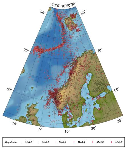
The two largest earthquakes in Norway's recent seismic history were centered along the coast. One in 1904 along the Oslofjord measured 5.4 on the Richter scale. Another one measuring 6.0 occurred in 1819 on the northern Norway coast near Mo I Rana (NORSAR 2007). A large exposed portion of the Sturoagurra fault located in Northern Norway in Finnmark demonstrates a fault scarp of about 9 m high which most likely resulted from an earthquake with a M>7 about 6-9000 ya. As recently as January 1996 this same fault had a 4.0 earthquake indicating that there is still activity here.
The build up of sediment load over millions of years has compacted into sedimentary rock layers which are known for containing hydrocarbons that produce oil and gas (UiB 2005). Organic material is broken down into carbon dioxide and stored in oceanic carbon reservoirs. Under pressure in the sedimentary rocks, the oil migrates to the porous layers and concentrates when sandwiched between nonporous sediment layers (clay, fine silt) (UiB 2005). These pockets are what miners are looking to tap into when searching for oil and gas reserves. Norway is the 3rd largest oil and natural gas exporter, only following Saudi Arabia and Russia (EIA 2006).
So what makes the deep waters off of Norway's coast so prosperous for hydrocarbon reserves? It has to do with gradual activity at the oceanic rift which has produced a sufficient environment for developing this natural resource. In Kenneth Deffeyes book, Hubbert's Peak (2001), he tackles the subject of the impending world oil shortage as a function of our insatiable desires to make bigger, faster, and bigger machines all reliant on oil and gas for production. The "sweet zone" for oil production is in organic-rich source rocks buried 7,500- 15,000 ft below sea level (Deffeyes 2001). For mining to be productive, we want a high concentration of the organic material in this area. In order for the hydrocarbons to accumulate and settle, they need to have a place to do this where they will be able to concentrate and collect without being spread out on the wide ocean floor.
Oceans are generally split into two autonomous layers. The first 100 m or so is termed surface water. It is affected by surface air, temperatures, winds and currents. Though generally warm, it is susceptible to wider turbulence and mixing than the remainder of the ocean which is classified as deep water. Deep water is uniformly cold and mostly still throughout the bodies of oceanic waters. This water mixes very little with the warmer upper layer and is comparatively dense which makes it stable and unchanging (Hamblin & Christiansen 2001). This is typically possible in areas with depressed basin which is conducive to low water circulation (Pascal & Cloetingh 2002). The various phases of Atlantic margin rifting play a part in providing these wells for hydrocarbon incubation. Studying the phases of the rifting as the crusts pull apart then continue movement with passive margin drifting has allowed scientists to focus their search for productive oil reserves (Lein 2005).
|
| Epicenters of Earthquakes 1980-2004 courtesey of UiB 2005 |
|
| Norway's areas of techonic pressure |
Last modified: 5/25/2007 5:35 PM
| References |