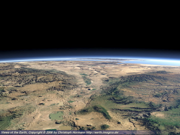
Above Image (Hormann 2007).
University of Washington, Tacoma, Interdisciplinary Arts and Sciences
Date Submitted: May 25, 2007
The Great Rift Valley is a large complex divergent plate boundary on the Eastern side of Africa, which extends a total distance of 3,000 kilometers. The Great Rift Begins in the Southwest portion of Asia and stretches all the way down to Mozambique. Along the axis of the Great Rift Valley, the earths crust is being lifted and spread apart in a long, ridge like fashion. The Rift Valley system consists of a large number of finger-like-troughs, each ranging in width from about 30 to 60 km, making up the complex system of plat tectonic activity, diverse climatic regions, and the site of anthropological wonders. (Strahler and Strahler 2006).
Near the Red Sea lies an area of the Great Rift Valley referred to as the Afar Depression, or the Afar Triangle, which is a geological depression in the Horn of Africa, overlapping Eritrea, the Afar Region, and Djibouti. This region is where the Arabian, Nubian, and Somalian plates meet, and is home to much plate tectonic action. Earthquakes are a regular occurrence in this area, due to the rifting of plates and geothermal activity.
The Afar depression, which is located in the Eastern region of Africa in the country of Ethiopia and is part of the Great Rift Valley, is considered to be an active plate tectonic phenomenon. According to Strahler and Strahler (2006), Plate tectonics is a theory of tectonic activity dealing with lithosphere plates and their activity. The Afar Depression was created twenty million years ago because of faults in the region opening and the interior landmass lowering between the three plates. Since then this area has been the site of geological, geographical and anthropological wonders.

Image from Hormann (2007).
The Great Rift Valley lies on a continental divergent plate boundary. Divergent plate boundaries are where the earth's rigid lithosphere is being separated due to activity in the flexible asthenoshere and is creating new lithosphere. Because of this rifting process, the Great Rift Valley is constantly changing and "pulling from East and West to cause the North-South divide" (Smith 1988). In concurrence with the North South divide, the Red Sea is now said to be widening by about 2.5 centimeters a year, which would mean an increase of 25 kilometers in only a million years (Smith 1988). The occurrence of both these phenomenon's in junction with increasing accumulative displacement is a definite threat to this region. This occurrence could possibly cause the separation of the African Horn someday, which would change the continent of Africa forever.
The Afar depression is the second most active area of volcanic activity in the
Erta Ale, one of the more well known volcanoes of the
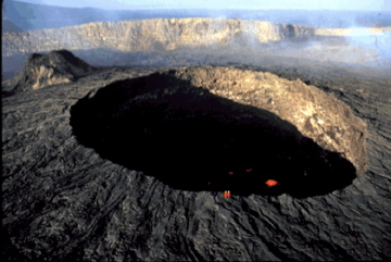
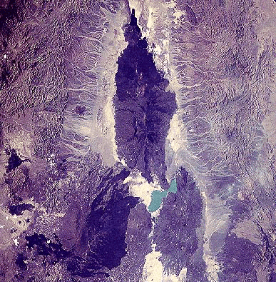
Image on the left, from Gunn (2006).
Image on the right, from Department of Geosciences at Oregon State University (2003).
Because of the diverse topography of the landscape and location in the Tropical zone, rainfall and temperature patterns are diverse in Ethiopia. According to the Koppen-Geiger system of climate classification, Ethiopia is positioned in the low-latitude climate zone and most of the areas would be classified as dry tropical or highland. In the dry tropical areas of Ethiopia, climate is marked by strong temperature cycles accompanied by extremely hot temperatures during the season when the sun is high. Rainfall is not abundant in these areas but still occurs when the Intertropical Convergence Zone is near. Temperature range varies due to the dry air and overall lack of cloud cover (Strahler & Strahler 2006). Due to the rifting the majority of Ethiopia would be classified as a highland climate because the rifting is causing the majority of the land to experience increased elevation. Examples of this would include plateaus, mountains, and volcanoes. The highland areas of Ethiopia are "cool to cold, moist climates that occupy mountain and areas of high plateaus" (Strahler & Strahler 2006). As a general rule, the higher the elevation, the lower the temperature. Precipitation is abundant in these areas.
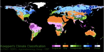
Image from FAO-SDRN-Agrometeorology Group (1997).
There is a wide variation in precipitation throughout the country because of the differing elevations and seasonal changes in surrounding atmospheric pressure. Because of these two factors, several regions receive rainfall throughout much of the year, while in other areas precipitation is only seasonal. There are three different environmental zones, including cool, temperate, and hot. The cool zone consists of the Western, Eastern, and central portions of the Northwestern plateau. The elevation in these areas are usually above 2,400 meters, the average daily highs range from freezing to16 degrees Celsius, nights are usually cold, and warmth quickly decreases by afternoon. The temperate areas of Ethiopia lie between 1,5000 and 2,4000 meters in elevation and daily temperatures in this region range anywhere from 16 degrees Celsius to 30 degrees Celsius. The hot zones encompass areas, which are lower than 1,500 meters; these include such areas as the Denakil Depression, the Eritrean lowlands, the Eastern Ogaden, the tropical valleys of the Blue Nile, the tekeze rivers, and the areas along the Sudanses and Kenyan borders. During the day, conditions are extremely hot and arid and average temperatures range from 27 degrees Celsius to 50 degrees Celsius. There is a wide variation in precipitation throughout the country due in large part to the differing elevations and seasonal changes in surrounding atmospheric pressure. Because of these two factors, several regions receive rainfall throughout much of the year, while in other areas precipitation is only seasonal (LaVerle, B. and Ofcansky, T. 1991 ).
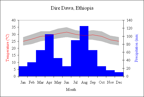
This Graph shows the monthly average of precipitation and temperature of Dire Dawa, Ethiopia, which is located in the Afar Depression.
The change in the earth's climate has recently been of great concern. Global warming, due to increased green house gas emissions, is causing an increase of the earth's average temperature as well as influencing other aspects of climate. Sub-saharan Africa, the location of the
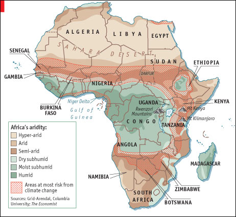
Image from the Economist Print Edition (2007).
Over time, the remarkable evolution and superb ability of apes to adapt to a variety of complex and diverse environments has spurred the evolution of mankind, making the Great Rift Valley one of the settings to the rise of Australopithecus and Homo, as we know them today (Smith, 1988). The
The abundant quantities of fossil records in this region can be attributed to "the slow sedimentation of Eastern Africa's rivers, the constant changes in drainage and faulting that accompanied the tectonic shifts," the unencumbered nature of the fossil beds, and the constant renewal and exposure of unseen land by erosion creating new layers of earth to be examined (Smith, 1988). One of the most famous fossil records discovered in this area is Lucy, a Hominid species known formally as Australopithecus Aferensis, which lived in northeast
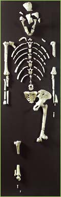
Image of Lucy from Veneziano (2006).
According to Behrensmeyer, the author of Climate Change and Human Evolution, both climatic and biological evolution has interacted throughout Earths history to spur the beginnings of man. The
Answers Corporation. 2007. Dire Dawa. http://www.answers.cpm/topic/dire-dawa, Accessed on May 24, 2007
A part of the New York Times Company. 2007. About Archeology: The Middle Awash. http://archaeology.about.com/library/glossary/bldef_middleawash.htm, Accessed on
Australopithicus Afarensis: The story of Lucy. http://www.wsu.edu:8001/vwsu/gened/learn-modules/top_longfor/timeline/afarensis/afarensis-a.html, Accessed on
Behrensmyer, A.K. 2006. Climate Change and Human Evolution. Science 311:476-78.
Department of Geosciences at
Ethioworld. 2000-2001. Places to Visit:
Ethioworld. 2000-2001. Places to Visit:
FAO- SDRN- Agrometeorology Group. 1997. World Climates. http://www.blueplanetbiomes.org/climate.htm, Accessed on
Gunn, B. M. 2006. The Oceanic Ridge Basalts: Spreading canters of the Eastern Pacific. http://www.geokem.com/ORB-oceanic-pacific.html, Accessed on
Hormann, C. 2007. Views of the Earth, Artificial Images of Our Real Planet: The Afar Triangle. http://earth.imagico.de/view.php?site=ethiopia, Accessed on
LaVerle, B. and Ofcansky, T. (ed). 1991.
Smith, A. 1988. The Great Rift:
Spaansen, J. 2003.
Strahler, A. and Strahler, A. 2006. Introducing Physical Geography, 4th ed.
The Economist Print Edition.
Veneziano, M. 2006. Storia di Pantalica:Origine ed Evoluzione della Specie Umana. http://www.archeologia.com/~pantalica/ominidi.htm, Accessed on
Wikipedia.