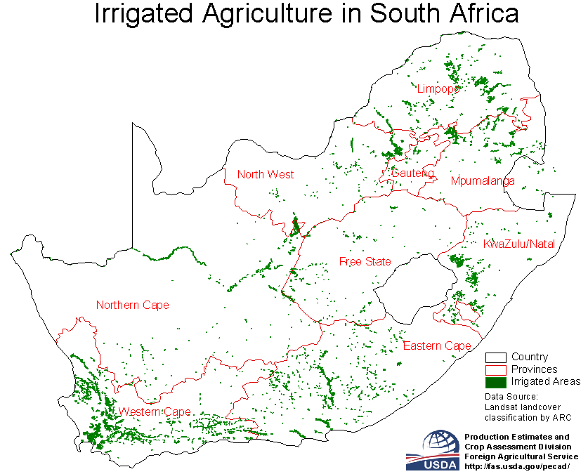
The Environmental Department of the South African Government reports:
"The overall feature of the distribution of the mean annual precipitation or MAP in South Africa is that it decreases fairly uniformly westwards from the escarpment across the interior plateau. Between the escarpment and the ocean in both the southern and the eastern coastal margins there is an increase of complexity of rainfall patterns as a result of the irregularities of terrain. The Drakensberg Mountains run almost parallel to the coast for the entire eastern side of the country, causing the irregular rainfall patterns in that part of South Africa.
About 35% of Southern Africa receives less than 300 mm per annum as a result of the presence of subtropical high pressure cells which inhibit rainfall generation because of the predominantly subsiding air."
Contrary to what I thought at first, the Western Cape does not have an abundant supply of water. Whenever I have seen pictures of South Africa I suppose that I am looking at the Garden Route and imagining a rich and green country. Water shortages are a chronic and severe problem in much of South Africa. The country has no commercially navigable rivers and no significant natural lakes. Along the coastline are several large lagoons and estuarine lakes, such as the Knysna Lagoon (5). The government has created several artificial lakes, primarily for agricultural irrigation. Water consumption in certain areas exceeds water supply, which means that water restrictions will inevitably become part of life for the inhabitants of the Western Cape. South Africa, it is believed, will be a water scarce country by 2025.
The recent National Water Act of 1998 attempts to fix certain shortcomings with regard to claiming water for the purpose of maintaining ecological systems. Accordingly, primary human consumption (water for drinking, washing and cooking) and ecological needs, together known as the Reserve, receives priority with regard to water allocations from a source. Because of this, the volume of water available for human secondary use (i.e. gardens, industries and irrigation) will have to be drastically reduced, and in certain areas consumption needs to be cut, to address the needs of the Reserve.
Agricultural activities account for nearly 55% of all water consumption in the Western Cape. Using water effectively will therefore become extremely important. Any future expansion in existing irrigation will only be possible from savings achieved in other current areas of water use.
Organizations, such as the South African River Health Programme, attempt to ensure that South African rivers are healthy through a holistic approach to their evaluation. They evaluate river health primarily using biological indicators such as fish communities, riparian vegetation, and aquatic invertebrate fauna. While these sorts of studies are useful in determining the ecological implications to riparian habitats, they provide only one piece of an enormous jigsaw puzzle pertaining to the health of wider ranging South African ecological systems.
The health of the agricultural industry is highly related to the ability of South Africans to irrigate their lands. As noted in the Soils section, the production of wine has been a priority for South African exporters and so the majority of irrigation efforts have been focused toward the wine regions of the Western Cape. Table. 1. Also important is the irrigation of sugar cane fields, sugar cane being another major export. Table 2.
Table 1. Irrigation in each province
Province | Area Irrigated |
Eastern Cape | 154,930 |
Free State | 98,980 |
Gauteng | 26,684 |
KwaZulu/Natal | 170,244 |
Mpumalanga | 157,420 |
Northern Cape | 161,874 |
Northern Province | 135,146 |
North West | 103,318 |
Western Cape | 281,536 |
Total | 1,290,132 |
Table 2. Contribution of Irrigation to Crop Production
| Crops | Area Irrigated | Production |
| Lucerne | 203 | 1600 |
| Wheat | 170 | 740 |
| Maize | 110 | 660 |
| Vegetables | 108 | 1330 |
| Other Pastures | 104 | 800 |
| Grapes | 103 | 1300 |
| Other fruit | 95 | 1200 |
| Sugarcane | 60 | 4000 |
| Oilseeds | 54 | 108 |
| Other small grains | 52 | 200 |
| Potatoes | 39 | 1200 |
| Citrus | 35 | 1100 |
| Cotton (lint) | 18 | 17 |
| Tobacco | 12 | 20 |

Because South Africa is essentially surrounded by escarpments the higher regions do not receive as much rainfall. Accordingly, there are no natural lakes. This is also due in part to the steep runoff of the highly scored mountain terrains leading to the coast.
The building of dams is therefore essential to the process of providing irrigation to lands of higher elevation. A prime example of such a dam is the Brandvlei Dam. (See Google Earth Placemark).
Last modified: 5/25/2007 5:53 PM
