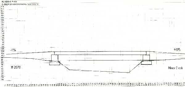
ROAD DESIGN Road design for this area was completed by the 1998 University of Washington Forest Engineering Senior Class. After review of their results, we found the overall design to be sufficient. Some additional design work was required at the crossings. This involved calculating the curve widening, fill slope ratio, and fill depth at the Mine Creek crossing, and designing the curve between W-2070 and the Little Washougal crossing. We also calculated the fill required at the approach to the Little Washougal bridge due to the raised elevation of the bridge deck. Mine Creek Based on the profile of the Mine Creek crossing, the design called for 20 feet of fill at the centerline. We found this to be accurate. The curve widening was found to be 14 feet, defining a running surface of 28 feet. This curve widening was found according to the methods outlined in Curve Widening Equations and Examples found in the appendices. Fill slope ratios of 1:2, 1:1, and 2:1 were evaluated to find the required length of the culvert. At 2:1, the culvert would be 118 feet long. At 1:1, the culvert would be 68 feet long. We found the plan for the curve across Mine Creek to be adequate. Little Washougal River
Based on the hydrologic analysis, the high water mark for the 100 year flood is 11 feet above the lowest point in the channel. This point was assumed to be a point in the channel near the Western abutment. To account for debris that may be flowing downstream during the 100 year flood, we have added five feet to the high water mark. This was used as the height to the lowest point of the bridge superstructure. In summary, we have designed for five feet of clearance during the 100 year flood. Curve Specifications:
The curve widening was found by the USFS method. Based on the current survey data and these numbers, it is safe to assume that the road is adequate as laid out as long as the proper curve widening is applied. Fill Specificatons for Bridge Approaches:
 Proposed Bridge Design with approaches shown.
|
