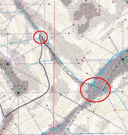
SITE DESCRIPTION The project site is located in western Skamania County, near Washougal, Washington. It is located in Township 3 North, Ranges 5 and 6 East, Willamette (WM). The Little Washougal River is classified as a type 1, fish-bearing stream. Mine Creek is a type 4, potentially fish-bearing stream. The Little Washougal River crossing is a bridge crossing. The Mine Creek crossing is a culvert or pipe arch crossing. See Figure 1.
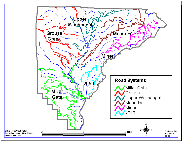
The following information is excerpted from the Washougal Landscape Management Plan. The Grouse Creek road system consists of two major roads, the GR and the MC roads including their spurs. This road system accesses the northwestern part of the Washougal landscape accessing about 2880 acres and stretching for 640 stations (12 miles) (See Figure 11.4 for Grouse Creek Road System Map)
Figure 11.1 The Six Major Road Systems within the Washougal Planning Area The topography of this area controls the location of most construction. Because of the extremely steep sideslopes that exceed 65% in most areas, ridge locations for road and landing construction are required. These adverse conditions prevent the necessary space required for traditional tower landings on sideslopes to be attained. In turn, road construction costs on steep sideslopes tend to be greater because of the amount of earthwork needed to attain the proper space, which includes major cut slopes, and excavation through rock outcrops. As a rule, any road development in this area should be located on ridges to reduce costs. The MC road starts near the end of the W-2070 road in the SW 1/4 of the NW 1/4 of Section 18 of T3N R6E. The road then crosses the Washougal River, follows Mine Creek and the subsequent ridge system until it connects with the GR-1 road at the SW 1/4 of the SW 1/4 of Section 11 of T3N R5E. The crossing over the Washougal River requires a bridge span of 80 feet and a clearance of 15 feet (see Figure 11.2 and Figure 11.3). The original log stringer abutments are still present and should aid in the relocation and reconstruction of the bridge.
Figure 11.2 Downstream View of Bridge Alternative 1 Where the MC Road Crosses the Washougal River.
|