FISH MODULE
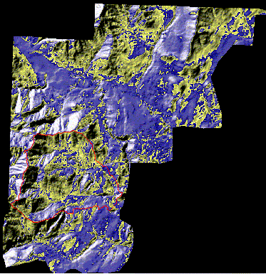
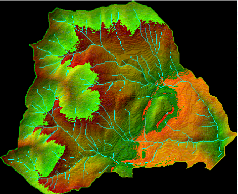
Using Arc/Info's GRID Module to Assess Salmonid Habitat in the John's Creek Watershed OVERVIEW During the Winter quarter of 1999, the FE 423--Watershed Analysis class, was asked to do a preliminary analysis of a watershed in the Hoodsport, Washington area on Department of Natural Resources (DNR) property. The selected project area was the John's Creek watershed, which is a small portion of the FE 450 capstone project (spring '99). The objective of this project was to facilitate learning about the utilization of GRID in watershed analysis and familiarity with the 1999-capstone project site. It is significant to note that each of the modules completed including this fish habitat module were done by a small group of students--a total of five with two graduates and 3 undergraduates--with varying degrees of watershed analysis experience. Consequently, the fish habitat module among others closely adheres to analysis done within the Forest Practices Board's manual, "Standard Methodology for Conducting Watershed Analysis." The following is one student's idea of assessing fish habitat using the GRID module. This report will be organized in the following fashion: I. Overview II. Introduction III. Data IV. Analysis/Results V. Conclusions I hope you enjoy this report and gain something from it. I know I sure have!! --T.Brown INTRODUCTION In this section I would like to give a very brief summary of salmonid habitat requirements. As we all know, fish--especially the salmonid species--have special requirements with regard to habitat. It is possible to identify and model the potential for salmonid habitat without visiting the actual site (which is what occurred in our situation). The degree of accuracy to which this can be accomplished has yet to be determined. However, utilization of this method allows a manager to get a preliminary idea of and form hypotheses about what he/she is working with in terms of resources. It helps a manager identify areas of concern that will need to be validated on the ground and possibly addressed in a management plan. It also points out flaws within the available data sets that will need to be addressed before optimal management can be achieved. Prime salmon habitat is essentially determined by two factors: (1) the elements of the physical stream environment; and (2) the availability of food. The necessary elements of the physical stream environment include moderate stream flows; cool, well-oxygenated, unpolluted water; low suspended sediment load; and adequate structural diversity. Moderate stream flows provide sustenance from upstream sources and assure adequate supplies of dissolved oxygen (DO) are available for spawning, etc. Several studies have concluded that the optimal stream temperature for cold-water species is a range of about 50-57 degrees Fahrenheit. The shading of the vegetation in the riparian zone and the contribution of subsurface flow to streams are considered to be the primary regulators of stream temperatures. A low suspended sediment load assures that little deposition of "fines" (fine sediment) occurs which fills in the space between cobbles and essentially makes it difficult for redds to obtain essential DO. Where deposition of sediments is likely to occur is an important factor in optimal management. Structural diversity applies to factors that alter stream morphology including large-woody debris (LWD). LWD can change the morphology and physics of a stream and provide both shelter and protection for salmonids. Where are the likely sources of LWD? Where is LWD deposition likely to occur? Where is the channel morphology such that LWD will likely be whisked away? These important factors can be explored with GRID. Stream systems have, for the most part, detritus-based food webs. This means the tiniest of organisms that sustain those higher on the food web rely on detritus. Detritus is largely an allocthonous input into a stream. In other words the composition of the riparian zone plays a large role in determination of the food supply available to salmonids. With GIS and GRID in particular we are capable of looking into and answering some of these questions based on the data we have and the scientific results that have come from extensive study of the salmonid species. Again, the accuracy of such analysis is left to debate, but as far as a preliminary inventory of what is "out there" based on the available information GRID does a nice job. DATA With this type of data there are going to be inherent flaws. DEMs are by no means pinpoint accurate. It is important to note that when you begin working with DEMs you should check it for sinks and fill them immediately. The best analysis is done with a smoothed DEM. Data is of utmost concern when doing this type of analysis. It is typically best to look at the data sets and attempt to ground truth them early on. For this particular project we did not have this opportunity. Consequently, we were "blind" as to what could be considered a realistic output for our analysis. This section briefly discusses the data we had available and some of the problems encountered. There were two sources of elevation data available for the Hoodsport planning area: (1) the United States Geological Survey (USGS) Digital Elevation Model (DEM); and (2) a Department of Natural Resources (DNR) DEM. Of these two we chose, I believe, the DNR DEM. B. Evans does a nice job of describing how this DEM was created. For more information about the DEM creation see the "DEM" section. The following is a hillshade of the DEM from which the John's Creek watershed was clipped (see Figure-1).
Figure-1-- Hillshade of the DNR DEM used in analysis with John's Creek watershed outlined in red.
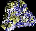
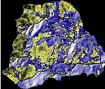
From this digital elevation model there were a number of steps taken to attempt to "improve the analysis." The John's Creek watershed area was clipped from the DEM. Subsequently, the clipped DEM was modified to make the topography flow more toward the DNR stream coverage. However, the result was flawed DEM to say the least (see Figure--2 and Figure--3).
Figure-2-- Hillshade of DNR DEM clipped to John's Creek extent. Values range from (123.7'-2,700.6').
Figure--3-- Hillshade of DNR DEM clipped to John's Creek extent and modified to fit DNR stream coverage. Values range from (41.5'-2,700.6').
To the naked eye there is not much difference between these two sections of DEM. However, you will notice that Figure-2 has what appears to be a stream network overlaid. This is in fact, an anomaly caused by our modification process and it makes a world of difference in the analysis. The original analysis was done using the flawed DEM and stream gradients approached the 400% level. This is because the method of lowering the DEM where the DNR streams were located then attempting to refill those trenches did not completely work. The filled DEM was almost 100' lower in some places than it was originally. After this flaw was noticed we chose to go with the original DEM clip in Figure-2.
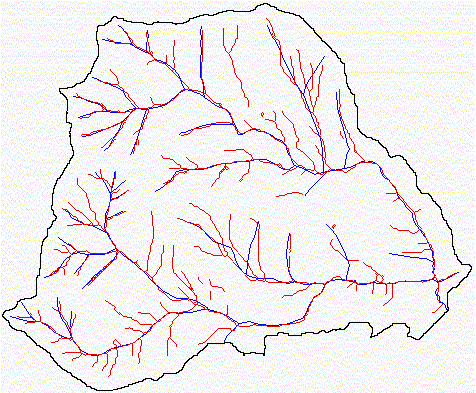
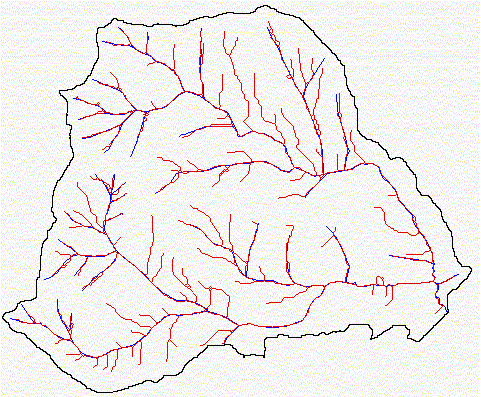
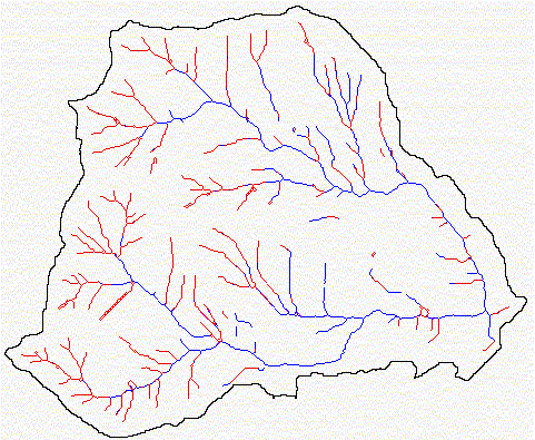
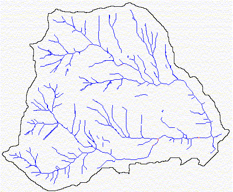
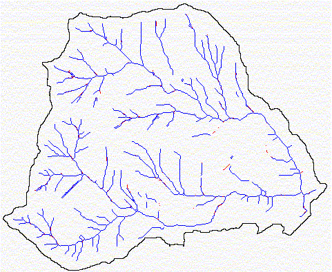
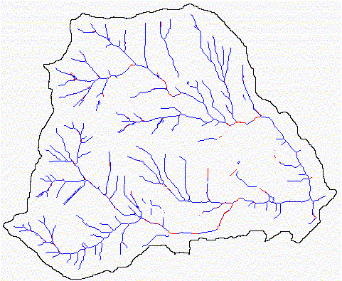
The next problem we ran into was selection of a stream network to analyze. There were three different networks that could be used in the analysis: (1) the network provided in the DNR hydro coverage; (2) a network derived from the DEM itself; and (3) the network created during the modification of the filled DEM above. Each had its own set of flaws. The DNR hydro stream coverage tended does not represent all the streams in the area. It is an "incomplete" coverage. A stream network derived from the DEM is most likely based on "stream power" and this method creates discontinuities in the channel network. It is a "discontinuous" coverage. The modified network was continuous and had many more streams than the DNR coverage. However, because the DNR channels do not match the topography of the DEM of choice there is a problem. And after hours of running analysis and coming up with outrageous values, it was determined we should go with the DEM derived network even if it is discontinuous. Figure-4 below shows both the DNR coverage in blue and the DEM derived coverage in red. Figure-5 below shows a comparison between the modified network (red) and the DNR stream coverage (blue).
Figure-4-- DNR hydro streams coverage in blue and DEM derived stream network in red. Notice the discontinuities in the DEM derived network. There are stream fragments all over the place. Notice how many more streams the DEM derived network identifies than the DNR hydro coverage too. The DEM derived network is the one used in our analysis.
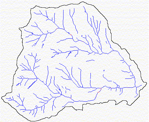
Figure-5-- DNR hydro coverage in blue and Modified stream network in red. The modified network does a better job of identifying more channels than the DNR coverage. However, because neither of these fit the topography of the DEM very well and modification was unsuccessful neither is very useful in this analysis.
Discontinuities occur in the DEM derived network primarily because of the way it is derived. Stream power can be estimated by multiplying stream gradient and flowaccumulation in GRID. However, when a stream cell has a low gradient its stream power is going to be lower too. Therefore, when you choose your stream network based on a minimum stream power it is inevitable that you will eliminate some stream cells because that cell's low gradient does not allow it exceed the minimum power you've established.
There are many more things we could tell you about the data, but we will stop here for now and let you figure some out on your own. Let us get into the actual analysis.
ANALYSIS
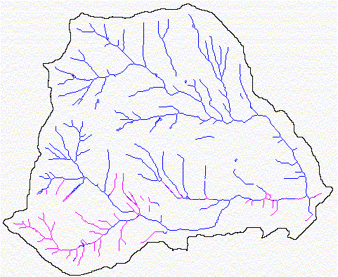
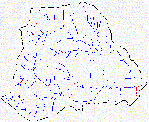
Now that we have faltered through several data sets and have determined the best one for our analysis (see Figure-6) we can move on to the fun stuff. One of the primary habitat concerns is whether or not salmonids are physically able to make it to a desired reach. Are there any blockages? If so, what are they? Are they manmade or natural? These are important questions for initial analysis because habitat analysis becomes insignificant if salmonids cannot make it there. The DNR data has fields for several types of fish blockages. However, there was not data for the John's Creek watershed pertaining to location of known stream blockages (e.g., waterfalls, dams, irrigation diversions, etc.). Therefore, the best we can do is determining fish passage strictly based on stream gradient. This section discusses each part of the analysis that was done. It does not specifically discuss the coding that was done to achieve the result. If you wish to view the code, click here on POWERBAIT.AML.
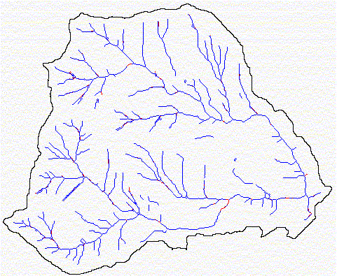
Figure-6-- Hillshaded view of John's Creek watershed with DEM derived stream network used for this analysis.
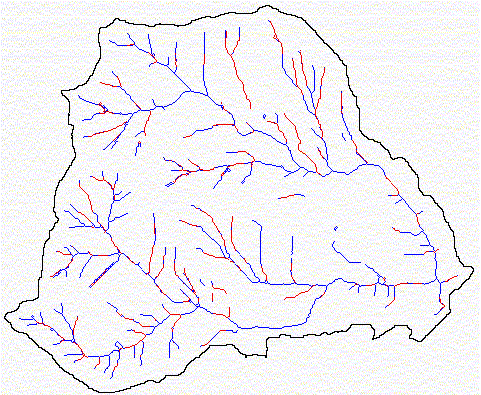
One of the most significant factors in fish passage in steep gradients is channel morphology. Using Table-E2 on page E-14 of the watershed analysis manual we can use confinement and stream gradient to generalize stream morphology. Stream morphology is important because even in steep gradients approaching those maximums above where no fish can pass, salmonids can may have a chance given the right morphology (e.g., adequately spaced pool-riffle morphology, etc.). The types of morphology defined in the WAM are: (1) poo-riffle; (2) plane-bed; (3) step-pool; (4) Cascade; and (5) colluvial. See Figure-6a for a map of stream morphology.
Figure-6a-- A depiction of channel morphologies based on WAM parameters. Red = pool-riffle, green = plane-bed, blue = step-pool, cyan = cascade, and violet = colluvial.
As noted before, we can determine topographical blocks to some extent with GRID. The best function to do this with is the FLOWDIRECTION function that allows creation of a "drop" grid. The drop GRID is an optional output grid showing a ratio of the maximum change in elevation from each cell along the direction of flow, to the path length between centers of cells, expressed in percents. This is the best modeler of stream gradients. It is generally accepted that prime habitat is usually located below 4% gradient. See Figure-7 for reaches with less than 4% gradients.
Figure-7-- Display of stream reaches with less than 4% gradient. Considered optimal reaches for salmonids.
The watershed analysis manual gives 15% as a general value for stream gradient above which you will find no salmonids. However, it is typically a value of 20% used in most cases. See Figure-8 and Figure-9 for reaches that are above 15 and 20% respectively.
Figure-8-- Stream reaches with less than 4% gradient in the John's Creek watershed. 4% gradient is generally considered optimal gradient for salmonid habitat. Notice how few reaches there are.
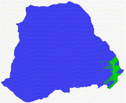
Figure-9-- Stream reaches with greater than 15% gradient in the John's Creek watershed in violet. 15% gradient is considered too steep for passage by salmonids by the Forest Practices Board in the WAM. Notice these gradients occur at the "mouth" of the watershed on the east end.
Figure-10-- Streams with greater than 20% gradient in the John's Creek watershed in red. 20% gradient is the typical recognized maximum gradient above which you will find no salmonids. Notice the watershed is pretty steep and these gradients occur at the mouth of the watershed on the east end.
Using these networks as inputs we can define that are of the watershed in which there should be no fish based on the stream gradients. The WATERSHED function is a handy tool in GRID for this type of analysis. Figure-11 and Figure-12 show that portion of the John's Creek watershed that would not have fish according to the available data.
Figure-11-- That portion of the watershed in blue in which you would expect no salmonid based on the maximum impassable gradient of 15% defined in the WAM.
Figure-12-- That portion of the John's Creek watershed in which you would expect no salmonids based on the maximum impassable gradient of 20%. Notice the similarity between this parameter and that of 15% above.
Logically, from the analysis we've done to this point it would be OK to conclude there is no fish in this watershed because the gradients at the mouth are too steep to allow fish further up in the watershed. This is something that would have to be verified on the ground. However, for our purposed we will continue on with more analysis.
The WAM also uses confinement in determination of fish habitat. There are several methods of modeling stream confinement. Their accuracy and feasibility can all be debated. In GRID, we are capable of using the Curvature of a surface as a surrogate for confinement. The CURVATURE function calculates the curvature of a surface at each cell center. There is also a "plan" grid option which creates an optional output grid showing the curvature of the surface perpendicular to the slope direction, referred to as the "planform" curvature. In modeling stream confinement I felt this was the most appropriate value we could use.
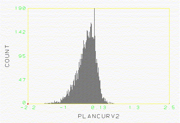
Curvature gives back a grid of values for the curvature of the surface of the second derivative of the surface function. Consequently, a negative value implies concavity, a positive value convexity, and zero value implies a flat surface. Let's take a look at the curvature values returned to us from the John's Creek watershed (see Figure-13).
Figure-13-- Histogram of the planform curvature values of streams in the John's Creek watershed. Values above zero imply a convex surface, below zero implies a concave surface, and zero equals a flat surface.
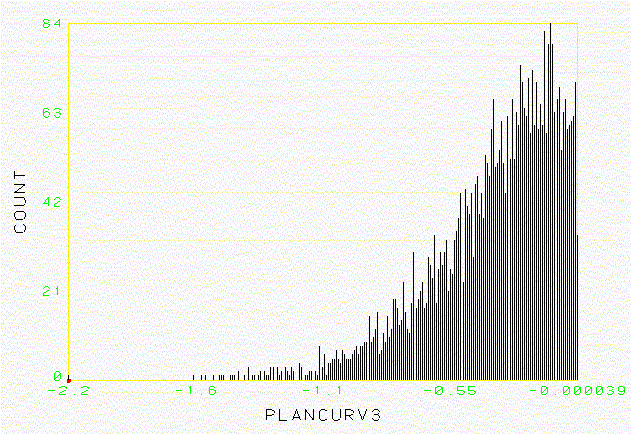
It is odd that we would have positive values in a stream network. After all, water does not run along the tops of convex surfaces. This is the first clue that confinement may not be the best modeler of stream confinement. This problem, I believe, stems from the fact you are trying to model type 1-5 streams with widths of maybe 2-30' with a cell of approximate dimensions 33'x33'. However, I will continue with this analysis. Since confinement is essentially concavity, I decided to take a look at just those values that were zero or below (see Figure-14).
Figure-14-- These are the planformcurvature values representing concave to flat surfaces such that they are only values less than or equal to zero. The smaller the value, such that the farther to the left it is on the histogram, the greater the confinment.
Using these inputs we can model or estimate according to our own arbitrary parameters the stream confinement within the John's Creek watershed (see Figure-15).
Figure-15-- Display of stream confinement with arbitrary parameters set by analyzer. Confined streams in red, moderately confined streams in cyan, and unconfined streams in blue. This is a decent depiction because you will tend to find most "confined" streams in headwater areas.
Based on the stream confinement I've defined, stream gradient, and the values set forth in Table-E2 (Channel Response Matrix) we can determine several key factors affecting potential salmonid habitat. By using the CON function and some basic coding we can determine reaches where "fine" sediment deposition is likely to occur (see Figure-16).
Figure-16-- Stream reaches in the John's Creek watershed where deposition of "fine" sediments is likely to occur in red.
Alternatively, we can determine reaches of coarse sediment delivery in the same way using the WAM (see Figure-17).
Figure-17-- Display of reaches within John's Creek where coarse sediment deposition is high in red.
Because stream morphology is directly related to discharge, of interest to us may be reaches adversely affected by discharge. See Figure-18 for streams which are susceptible to bank erosion, frequent scour, and deep scour. Salmonid redd are susceptible to damage from scour so these areas are vital to identify.
Figure-18-- Reaches within the John's Creek watershed where bank erosion, scour depth, and scour frequency are a potential problem in red.
Catastrophic events significantly impact stream habitat, by introducing debris, including large woody debris, and sediment to the stream. Knowing where areas of debris flow scour and alternatively debris flow deposition. See Figures 19 and 20 for identification of these areas.
Figure-19-- Reaches in John's Creek watershed where debris flow scour is a potential problem in red.
Figure-20-- Reaches in John's Creek watershed where debris flow deposition potential is high.
Large woody debris accumulation and loss are of utmost concern in fish habitat. Using the channel response matrix we can define reaches where the dynamics are such that LWD will probably be flushed through and alternatively where it will accumulate. See Figures 21 and 22 for identification of these reaches.
Figure-21-- Reaches where large woody debris is likely to be flushed through due to channel dynamics in red.
Figure-22-- Reaches where LWD will be likely to accumulate given the channel dynamics in red.
All of these are of significant to salmonid habitat. There are several other approaches we can take including looking into the shading of the stream and the riparian composition. These would be good indicators of stream temperatures and food supply. However, Flo does a nice job of identifying these areas in his Riparian module. So, instead of stealing his thunder I will give him the stage. These could be nicely incorporated into a synthesis portion for fish habitat. However, due to time constraints we did not get to this portion.
CONCLUSIONS
Given the information we had I would have to conclude that there is a very low probability salmonids reside in this watershed. The gradients within the watershed are steep and are greater than 20% in a lot of areas. The mouth of the watershed at which salmonids would enter to spawn has greater than 20% gradients itself rendering the rest of the watershed uninhabitable.
I am skeptical as to the validity of most of the data sets we had. However, as noted earlier this is a good start and gives us plenty to check in the field. There are several improvements that could be made to the data set. A major one would be to include Washington Department of Fish and Wildlife species distribution data for the area. From this we would have a better idea of where fish actually reside and could do a better job of modifying data sets.
I am not fully convinced of curvature use as a modeler of stream confinement. As I noted it is very difficult to justify this type of analysis where you use a cell of 33'X33' to model what is occurring in a width of 2-20' on most occasions in this small watershed. I hope you got a little out of this analysis and suggest studying the code in powerbait.aml.
|