CHANNEL AND RIPARIAN MODULES
IntroductionA modern approach to watershed analysis should be based on computer modeling as a first step, providing some guidance, narrowing down the field analyst's research who would then adjust and complete digital results. Such an approach would save time making watershed analysis more effective.Because of the standardized methodology currently applied (WAM) it appears that sooner or latter the computer modeling part of analysis will evolve in a software package widely applicable. Again the results are not to be expected very precise but seen as an input for field verification. Links: Channel ModuleOverviewChannels are defined by the transport of water and sediment confined between identifiable banks (Montgomery and Dietrich, 1989). Channel morphology reflects the processes in the watershed, material from hill slopes being eroded and ending up in the streams where it is transported through the channel network. Thus channels condition is an indicator of the watershed condition.The analysis here performed is based on patterns in morphology and processes available to computer modeling, allowing some conclusions to be drawn. The questions the WAM addresses are:
Data inputsThe data we had to work with had limitations and errors that influenced the channel module as well the whole analysis.The stream coverage was delineated as a minimum power (stress) network using formula: Stress = depth * slope * unit weight of water (force / unit area) The original digitized DNR stream coverage, considered most accurate
was the starting point then the digital elevation model was forced to align
with that. The streams were then generated from the new DEM with the imminent
consequences of precision lost.
MethodThe core of the analysis is the WAM stream response matrix (table E-2), that classifies geomorphic processes according to stream characteristics:
where fs - fine sediment deposition, cs - coarse sediment deposition, sd- scour depth, sf - scour frequency, be - bank erosion, wl - wood loss, wa - wood accumulation, dfs - debris flow scour, dfd - debris flow deposition, db - dam break flood The analysis was performed both in ArcGrid and ArcView, trying to develop
an easy to use tool that will give non-GIS user an easy way to solve the
problem.
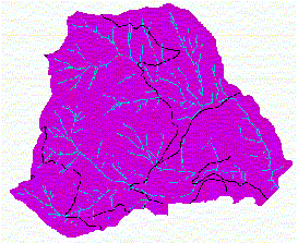
Due to the lack of stream bed and valley width data stream confinement had to be estimated using surface curvature. Determining confinement class breaks is an important factor in accurate modeling of stream response. Class breaks were equally set at thirds of curvature range, based on class histograms and aerial photos as reference. Such an approach has yet to be proven by field inspection. Most of John's Creek watershed fall in the moderately confined and unconfined categories. Stream sensitivity to Large Woody Debris inputs is considered under
the Riparian Module
Results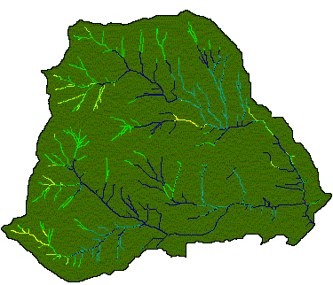 Sediment Deposition
ConclusionsAnalyzing the above, John's Creek watershed appears dominated by high gradient streams that facilitate catastrophic events and wood loss processes. Fine sediment deposition hardly occurs in lower areas towards the output point of the basin and discharge sensitive processes are well represented.Riparian ModuleOverviewRiparian areas are important for supporting environmental requirements of fish from the point of view of both water temperature and presence of wood in streams. The goal of this module is to provide an understanding of the current condition of riparian areas and impacts of possible logging.The module is structured in two parts: Riparian Shade and Large Woody Debris Recruitment. For each part a comparison of the actual case with the scenario of harvested 50 year or older stands was considered. Data inputsThe module requires both spatial and land cover data provided by DNR's RIU and DEM. Grids of dominant species, canopy percent, average tree height and diameter at breast height were generated from RIU stand coverage. Our confidence in data is low due to data inconsistencies observed (especially regarding DBH).John's Creek is entirely covered by Douglas Fir as primary species-
image not shown.
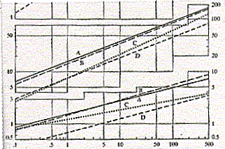
Riparian ShadeMethodRiparian shade is estimated as the difference of the available shade and the desired target shade. The target shade is established with the TWF temperature standards for Western Washington; for the study case, non glacier fed class A streams the standard is 18.3 degree Celsius.Minimum shade is a function of elevation and was derived from the modified DNR DEM. Riparian shading is considered effective for all streams less than 100'
wide. Stream width and depth were estimated using Dunne and Leopold's "average
values of bank full channel dimensions as functions of drainage area" for
San Francisco Bay region (graph A). All of John's Creek streams are below
this threshold.
Available shade depends on stream width, tree height, stand density, local topography and Sun's position on a particular moment of the day. For this analysis four relevant time periods were considered: 10 am, 12 pm, 14 pm and 16 pm. Shade needs in percent were computed with the following equation: shade needs = con[topo shade, 100, height * abs(sin(str
orientation - sun azimuth)) * canopy / tan(sun altitude) * stream width]
For identifying the most impacted streams we identified the values that stay unchanged over the day intersecting the grids of exposed waters at all time periods considered. ConclusionsEven though the average DBH is low it can be noticed that a possible harvest on the 50 year or older stands could leave most of the streams exposed.Large Woody Debris RecruitmentMethodThis part of the module assesses possible hazards in LWD recruitment for short and long terms.Determining recruitment hazard is based on the channel sensitivity to wood inputs and riparian recruitment potential. Channel sensitivity was delineated according to stream gradient and valley confinement using the matrix:
It can be observed that most of the streams fall in the low category
meaning they will not be impacted by wood - consequence of high gradient.
Due to low tree height (this is where the data proves inaccurate) the
recruitment potential appears as low all across the watershed.
Results:
Recruitment hazard LWD on /off - real case
higher hazards mean lower probability of valuable LWD in streams for the immediate term. ConclusionsGiven the data we had to work with, results showing John's Creek watershed in a poor condition from the LWD point of view are not surprising. A potential harvest of the older stands wouldn't make much difference for wood in streams but would strongly impact shade and stream temperature.References and AcknowledgmentsStandard Methodology for Conducting Watershed Analysis (Chapters D and E). WA Forest Practice Board, Version 4.0, November 1997.Water in Environmental Planning. Dunne Thomas 1943 Put together by Flo Damian evenflo@u.washington.edu winter 1999.
|