Tyee South Design Project
2002
Harvest Plan
Prepared for the Washington State Department of Natural Resources
University of Washington
Senior Forest and Ecological Engineering
Class of 2002
Eric Forner, Senior, FEE
Nathan Werner, Senior, FEE
Russ Foisy, Senior, FEE
Matthew Ghiorse, Senior, FEE
Jeff Wale, Senior, FEE
June 10, 2002
| Executive Summary |
| Introduction |
| Engineering Rationale |
| Management Plan |
| Appendices |
|
| References |
| Resumes |
Technical Summary
The senior class of Forest and Ecological Engineering at the University of Washington has contracted with the Washington State Department of Natural Resources to develop harvest plan for a parcel of land located on the Olympic Peninsula north of Forks, Washington. The goal of project is to design a management plan encompassing the harvest opportunities and transportation needs for the life cycle of the timber, with an emphasis on the next 10 years. Other considerations include, a transportation plan establishing landing locations and a road systems based on the landing locations, a ten year action plan indicating sale units and road systems to be used in that time period. We also expect to identify commercial thinning areas and resulting road access.
Environmental impact must also be addressed. Road analysis will take into account sediment run-off to local streams. Culverts and bridges will be located strategically to minimize sediment delivery. Soil types and topography will be analyzed to determine slope stability. Stream restoration will be considered in the planning of roads through abandonment, maintenance, and new locations.
Team: Eric Forner, Russ Foisy, Matthew Ghiorse, Jeff Wale , Nathan Werner
Winter Quarter 2002.
Introduction
The planning area includes three sections of land in T29R13W and T29R14W. The land is state owned and managed by the Washington State Department of Natural Resources. There are several functional requirements and constraints which the DNR has given the team to deal with in managing the land. These can be seen in the House of Quality diagram. At the end of the team project we will be able to look back at our House of Quality to determine if we met our functional requirements.
Design problem statement
The problem is to produce a timber harvest plan for the next 10 years for the Tyee South area in question and to include a potential management strategy for the next 60 years.
The objectives of this team are:
A modified house of quality as been created to indicate where functional requirements, constraints and goals meet. This will be used to determine if our efforts have been successful at the end of the quarter.
Proposed solution
For a more detailed look at what we will be doing to approach the problem see the Engineering rational and the Gant chart.
Activities will include collecting data, timber modeling, and determining preliminary setting boundaries to be used. Analysis of different situations can be conducted by using the appropriate software (see engineering rational). At this point preliminary road design can be established and alternative harvesting methods will be analyzed. After this a period of field work will begin that will include gathering data and making measurements. Then a final plan will be made involving all of the components and it will be presented in June.
Highlights of Technical specifications of the problem.
The harvest will generate cash flow. Stands will be managed for a 60 year
rotation. Thinnings and roads will be used strategically. Fish and wildlife
habitats will be maintained or improved.
Data collection:
GIS with several pertinent coverages and data bases will be gathered and analysed. Silvicultural information will also be gathered using GIS data and analysed.
State of the Art:
The design work will involve a continuous flow of input and output data that is acquired from previous design parameters. This flow of data will lead to a finished design that will encompass the entire project.
Highlights of the “Management Plan”
The main points in our management plan will be preliminary planning, the collection of data, preliminary timber modeling, watershed analysis, preliminary road design and preliminary alternative harvest systems analysis, FIELD WORK, final road design, final timber modeling, and final alternative harvest systems analysis. The fieldwork will have to be completed before the final designs and analysis can be completed. The first phase of instruction and analysis will take place at Pack Forest remote from the actual site to be harvested. The second phase will be out at Forks near the harvest site. The final phase will be back at Pack Forest to produce the final harvest plan.
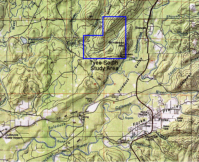
In 1990’s the Washington State Department of Natural Resources acquired a forested parcel of land on the Olympic Peninsula north of Forks, Washington. The parcel is in the Tyee South area and is roughly bounded by Gunderson Mountain to the east, Tyee Ridge on the west, the FR-D-2000 road to the south and the general extent of Trust ownership to the north. The legal description is Sec. 18, 19, T29N, R13W; Sec. 24, T29N, R14W. Figure 1 shows the location of the parcel.
Figure 1
Problem Description
The area of interest requires a management plan encompassing the harvest opportunities and transportation needs for the life cycle of the timber, with an emphasis on the next 10 years. There is an owl circle located within the planning area that will be in affect until the year 2007 that must be taken into consideration. There is also an area within the site that will be surveyed for murrelets until 2004. The transportation plan establishes landing locations and a road system based on the landing locations. The 10-year action plan indicates sale units and road systems to be used in that time period. We also expect to identify commercial thinning areas and resulting road access.
Environmental impact must also be addressed. Road analysis will take into account sediment run-off to local streams. Culverts and bridges will be located strategically to minimize sediment delivery. Soil types and topography will be analyzed to determine slope stability. Stream restoration will be considered in the planning of roads through abandonment, maintenance, and new locations.
Below, Table 1 illustrates the customer’s functional requirements (left) and certain constraints and goals (bottom) that when considered and met will ensure customer requirements are fulfilled.
|
Generate Cash Flow |
|
|||||
|
Improve Stand Quality |
|
|
||||
|
Promote Safe Working Conditions |
|
|
||||
|
Optimize Landing Locations and Setting Boundaries |
|
|
||||
|
Optimize Road Locations |
|
|
|
|||
|
Develop a 5 yr Harvest Plan |
|
|
|
|
|
|
|
Maintain and/or improve Fish Habitat |
|
|
||||
|
Harvest “X” MBF |
All Landings meet FP |
All Roads meet FP |
Commercial Thinning |
60 yr Road Plan |
All Stream Crossing Meet FP |
Table 1
Technical specifications of the problem
From the above table there are several functional requirements that the team developed. Cash flow will be generated from a five year harvest plan with consideration of future harvest opportunities in a 60 year rotation cycle. Stand dynamics will be addressed and thinnings will be prescribed to improve the stand quality. Landing locations, setting boundaries and a road system will be strategically placed to ensure efficiency in both the 60 year transportation network and the future harvesting prescriptions. Fish and wildlife habitats will be maintained and/or improved in accordance with state regulations.
There are a few constraints that must be considered when attempt to fulfill the functional requirements described above. In order to generate cash flow a certain MBF (thousand board feet) must be harvested. This is limited to the stand dynamics to be analyzed using growth modeling programs described in the engineering rationale. All landings, roads, and stream crossings must be designed in accordance with all pertinent Forest Practices rules and regulations.
Goals
The site of interest was acquired by the Trust Land Transfer Project. One of the principle goals of this trust is to generate immediate and future cash flow. The income production from this project will contribute to the income of the entire Sol Duc landscape. Due to the relatively small size of the planning area the site can never be self-sustaining. We expect income to be produced on a ten-year cycle.
Our team will generate revenue by developing a 10-year harvest plan. We are unsure of exactly how much timber will be harvested but we know that this will enable us to optimize landing and road locations, generate cash flow, improve stand quality in the case of thinning and provide direction for the 10-yr harvest plan. Within the plan we will identify and propose stands that are ready for immediate harvest and prescribing regeneration cuts in those areas. Some immediate revenue may be created through possible thinning prescriptions; however these silviculture methods will primarily be advised to enhance the growing space of future harvestable trees. We will also be evaluating a possible harvest plan that spans one rotations cycle, defined by the customer to average 60 years. A final harvest age generally ranges from 50 to 80 years.
In order to ensure efficiency during the harvest plan, optimizing landing locations and road design is paramount. This will be fulfilled by analyzing the current road system already present at the site, as well as establishing a proper time line that allows the team to decide if and when roads should be abandoned, maintained, or new roads constructed. As stated above, one rotation cycle defined by the customer is 60 years. The team will therefore establish a 60-year road plan that coincides with the future harvest plan.
Another requirement stated by the customer is that environmental aspects be carefully defined and observed. This will be accomplished by maintaining and/or improving fish habitat, carefully following the Habitat Conservation Plan (HCP) adopted by the Washington State DNR and following the Forest Practices (FP). Proper culvert and road placement, as well as removing all unnecessary culverts and abandoning all unneeded roads will further insure that these environmental safety requirements are met, where sediments and slope stability are involved. In addition, all roads, landing locations and stream crossings will meet FP.
The engineering team plans to present the proposal which is to cover all necessary
customer requirements as described above to employees of the Washington State
Department of Natural Resources on June 10, 2002.
Data Collection
The first step in the engineering process is to collect the required data that is needed to solve the problem. The data is acquired from the DNR and comes in the form of GIS coverage, reference materials, harvest and road building equipment cost and production estimates, and silviculture data.
GIS coverage includes:
DEM (Created from 1:4800 contours), Hydro (stream network and polygons), Trans (Road network), POCAL (Public Land Survey Boundary Info), RIU (stand data), Soils (soil inventory), RMUALL (current and pending timber sales), Boundary (Built by UW for clipping state-wide layers), Ortho_s (digital ortho photos -- topographically corrected aerial photos), PLS-PT (Public Land Survey Point Layer – statewide surveyed corner positions), POCA (Political Boundary Lines – Section Lines), Precip (statewide precipitation cover), ROS (statewide rain on snow), Storm (Coverage of precipitation during a storm), WAU (Watershed units), Mastertic (Tics for calibrating digitizers), Landsat (Digital satelite images), Unstable Slopes (DNR cover of unstable slopes), Towns (township boundaries)
It is important to note that not all this data will necessarily be used, but will be available. A significant part of the data collection process is to decipher which data will be important for our needs.
There is a wide array of reference materials used in the project. These include the Habitat Conservation Plan (HCP), Landscape Management Plan (LMP), Forest Practices Act (FPA), Watershed Analysis Information (including wildlife issues, erosion issues, and unstable slopes analysis), text books, technical documents, maps, the UW FE Handbook (available on the FE 450 website)..
Harvest and road building equipment cost and production estimates were acquired from programs such as SL-Pro, previous FE design proposals, USFS Region 6 costing spreadsheets and from the FE field trip to the Oregon Logging Conference in Eugene. This data will be used for cost analysis and equipment performance ratings.
Necessary information that may be needed for silvicultural analysis includes average tree size, average log size, reasonable tail tree size, and total volume of stands. More information about this can be found in preliminary timber modeling.
Current State of the Art
The design work will involve a continuous flow of input and output data that is acquired from previous design parameters. This flow of data will lead to a finished design that will encompass the entire project.
The first step in the design process is to establish preliminary timber models. This can be prepared by gathering a Forest Resource Inventory Summary or FRIS data. FRIS data and statistics are used to gather information pertaining to frequency of adequate tail trees, piece size, cut volume, and turn weights using programs such as Forest Vegetation Simulator (FVS), Suppose, LMS, Logger PC, and Plans. This information will be needed to design setting boundaries, landing locations, and a timber harvest schedule.
The next step in the process is a watershed analysis. Watershed analysis can be divided into two separate areas of interest, stream generation and sediment delivery.
Three aspects must be kept in mind when determining stream generation; stream location, power, and accumulation. Stream generation can be computated by downloading topographical information into an ArcGRID and Digital Elevation Model (DEM) program in GIS. These tools will generate flow direction and flow accumulations and stream power.
Predicting streams using ArcGRID is more accurate when considering high gradient and incised topography than in low gradient and flat topography. This is due to microtopography that does not appear in the DEM.
Sediment delivery will be calculated using three different methods. These methods include the surface erosion potential, Shaw-Johnson mass wasting, and the infinite hillslope equation.
The surface erosion potential is detailed in the Washington Forest Practice Board Watershed Analysis Procedures (WAC 222.22) and involves combining GIS soils coverage, k-values which can be obtained from the USDANRCS Official Soil Series Descriptions (http://www.statlab.iastate.edu/soils/osd/) for the soils, and a DEM model to predict the susceptibility to erosion of the soil.
The Shaw-Johnson mass wasting uses slope percent classes and slope form to identify high, medium, and low vulnerability to mass wasting. The slope form layer is developed using ArcGRID and the DEM for the area.
The infinite hillslope equation uses a free-body force analysis approach. A factor of safety can be determined using specified parameters and the equation. These numbers represent a ratio of soil strength relative to the predicted failure strength on a cell by cell basis, using ArcGRID for the analysis.
Next setting boundaries and landing locations are to be determined. An extensive analysis of the current road system is first completed in order to limit the cost of new road construction.
Landing locations will then be determined by deciding what harvest prescription is needed for the immediate area, information on what type of yarder is being used if cable yarding is prescribed (this information will be obtained from the alternative harvest methods later on in the design work), and using a contour map to choose adequate topography (i.e. relatively flat terrain preferably on ridge tops)
The setting boundaries will mainly be determined using the PLANS program. The following information are inputs into the PLANS program: max slope rigging distance, desired payloads (determined from timber modeling), minimum required ground clearance, carriage height when logs fly clear, carriage weight, tower height, tailhold height, allowable skyline tension, skyline weight, and mainline weight. The outputs of plans are: setting boundaries, cable profiles, and payloads.
Another important computer program that may be used in determining the setting boundaries and the landing locations is LoggerPC. LoggerPC inputs include terrain information, yarder types and carriage models. It is helpful in profiling cable units and estimating payloads.
Once setting boundaries and landings are determined then roads can be established from current usable roads to the landings. For the initial layout of the roads we will use a GIS coverage of the area that was acquired through LIDAR. Next roads are designed using Pegger in GIS. We will peg out a road system to connect landings to existing roads or roads that we feel are in better placement then the existing roads. The old conventional method of contour maps and a divider to determine the desired grade and peg the road in between the control points, landings, and existing roads may be used when areas are hard to see on the computer.
We will then develop map coverage of side slopes, road grade and alignment, and use this in the preliminary road design process. These designs will follow HCP rules for road construction. Whenever possible we will try to avoid pegging a road across a potentially unstable slope or fish bearing streams (determined from watershed analysis).
In the field we will set grade line, set P-line, traverse all of our designed roads, and run corridor profiles. The data that will be collected will then be taken to the office and used to create a final design.
There are many different methods of traversing; we will use more than one. Here are three methods and the equipment needed to do these; staff, compass, and chain, Criterion impulse laser, and a Lasertech impulse laser, MapStar digital compass, and a Hewlett Packard data recorder. Refer to the FE handbook (http://courses.washington.edu/fe450) for instructions on the operating of these instruments.
Roadside ditches impact watershed hydrology by intercepting surface and subsurface flow and rerouting the flow to the stream. A modified flow direction map, in which roads intercept downslope flow, can be made to counteract these effects.
Finally an alternative harvest method can be planned. The current practices employed for harvesting timber include: ground-based systems, cable yarding systems, and helicopter systems. Helispace and Simyard are two programs that can be used to compare helicopter verses cable yarding on slopes over 30%. Preliminary decisions can be made based on a cost analysis using the software. On slopes under 30%, ground based systems will be used unless there are overriding environmental concerns for that area.
Information obtained from the timber modeling can be used to determine logging prescriptions. Adequate tail trees must be located to set up a cable logging system. Equations such as Nakamura’s will be used to determine the holding capacity of the stump.
Preliminary Analysis
A potential solution that has been considered is to obtain a sustainable eco-system that that provides an economical return to the DNR. This can be done by following the HCP that the DNR has made with the Federal Government. Regeneration cuts can be made in the design area, but must not border each other. Separate age classes should be established in a surrounding area in order to create an environment that can retain the natural species of plants and animals.
Conclusion
These designs must be implemented with functional requirements and constraints in mind. We must meet the desired cut volumes that the DNR needs, while keeping environmental, economic, ethical, and safety considerations in hand.
Preliminary models will be run in each area of interest. Once data is acquired
then field test will verify our findings. Final models can then be determined
from corrected information obtained from the field.
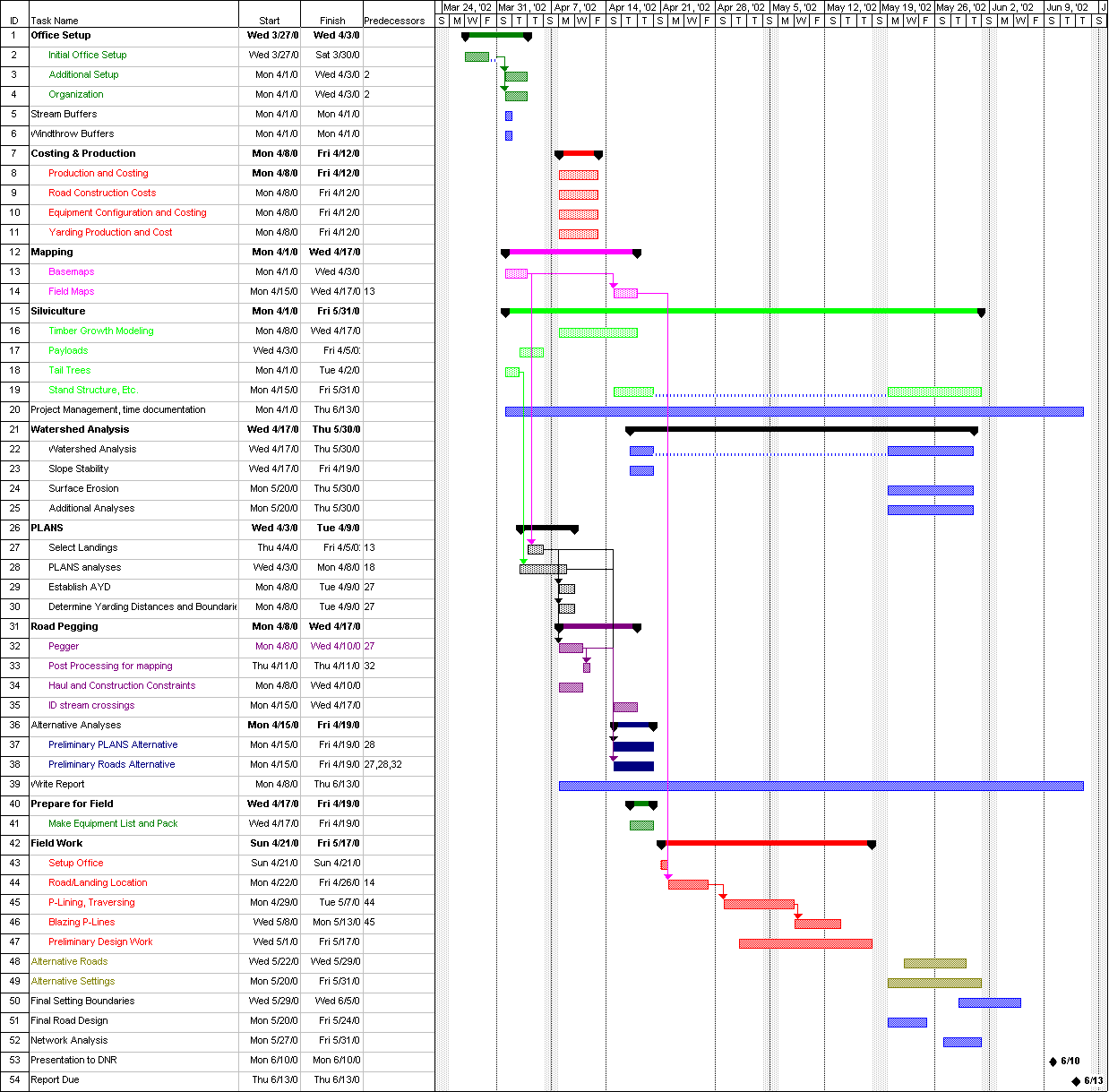
Refer to the Ghantt Chart for a detailed timeline of when tasks should be started
and when they should be finished.
Ongoing Tasks
Preliminary report work can include preparing a report template in Microsoft Word, and writing about some of the completed tasks such as data collection and watershed analysis. When multiple people are writing a single report, it is difficult to create a cohesive product. Starting with a template for the report will make life at the end of the quarter much easier because the format will already be the same for every section of the report.
Base maps must be created very quickly after arrival at Pack Forest so that road and setting design can get underway. Base maps are created for use in road pegging and setting design. They include such information as contours, streams, existing roads, wetlands, timber data, and unstable slopes, to name a few. The maps are plotted using AMLs.
Week 1:
The first step in the process to complete the given project is to set up the office at pack forest. This includes setting up the network and moving the equipment down to Pack Forest. Also, the computers should already be loaded with software and ready to go. This is done by CFR staff. Additional work includes setting up computers, digitizers, and printers, organizing the workspace, and many other tasks. It is to the design team’s advantage to finish these tasks quickly so that more time can be spent preparing for the field.
Project management is an important part of the FE 450 project so that we the students can see what it would be like to do a real world project. Project management start-up includes creating an overview of the project (using Microsoft Project) and preparing a system for keeping track of the use of our time. This system will include, as a minimum, a daily record of the tasks each person was involved in, and the amount of time spent on each task.
Collecting data is a huge part of the project in order for us to meet our determined goals. Data collection includes collecting and manipulating GIS data layers from DNR, collecting numerous reference materials, collecting harvest and road building equipment costs and production estimates, collecting and developing silvicultural data, and conducting interviews with DNR and other specialists. The collection of data will then lead to the design team picking out the useful material and then starting to manipulate the data to come up with the plan.
Production equations entail an analysis of productivity for various harvest systems, including ground, cable, and helicopter systems. Products will include $/MBF, Lateral Yarding Distance, and target External Yarding Distance for the harvest systems included in our analysis. This information is necessary for the cost analysis and for the alternate harvest systems analysis. The 1999 and 2000 Capstone Project CDs contain a lot of information on production equations. They are available on the CFR network at highlead/home/fe/pack_forest/pack_1999/hoodsport_99/production and highlead/home/fe/pack_forest/pack_2000/production. For information on helicopter production, use the USFS Helipace program.
Watershed analysis primary focus is to create a slope stability layer, typically using the SMORPH model. Additional analysis may be performed to determine landslide probability, sedimentation from roads, and other environmentally significant data. This data is then factored into road placement and harvest strategies.
Statistics will be determined for frequency of adequate tail trees, piece size, cut volume, and turn weights. Software used will include Forest Vegetation Simulator (FVS), suppose, and perhaps LMS. Initial data will come from the original Forest Resource Inventory Summary (FRIS) data. This data will be used in Logger PC and Plans in the setting design.
The preliminary setting design will be determined from the harvest equipment selected as the best alternative for the area. We will determine the type of yarder, size of tower and carriage, the expected payload weight for the area, and use the specs from these items. The setting analysis is then planned out by choosing the best landing location for every area of timber. Use roads, streams, and other topographical features as your setting boundaries. The PLANS computer program will help you to find landing locations with the best profile deflection. Analysis of cable units is performed using PLANS and LoggerPC. In order to calculate payloads and deflections on analysis of skyline profiles, much input data is required. We need the different input data from the yarders, timber, and the ground.
In order to determine the best possible recommendation for our client, we analyze several different harvest systems. Typically, this includes a comparison between long span and short span cable systems, helicopter systems, and ground systems. The alternate harvest systems analysis is closely related to the preliminary setting design, because it often involves the same procedures to determine the potential for using alternatives. In short, the preliminary alternate harvest systems analysis consists of doing preliminary setting designs for all of the different harvest systems to be analyzed. Typically, the software involved is PLANS, LoggerPC, and Helipace.
Week 2:
The road design is laid out once you have covered your planning area with settings, you must connect all the landings to the existing road system. Lay in the roads on the mylar maps that we plotted so that we can avoid hazards. We can also design multiple routes so that there are options available if something doesn't work in the field. This is done through a process called pegging. We will do this in ArcView, using an AML called pegger. Important considerations include side slope, road grade, alignment, and stream crossings.
Week 3:
In addition to packing, field preparation includes creating field notebooks and field maps, and examining field equipment. All students should understand how the equipment works (and make sure that it does work) before leaving for the field. All students should understand proper note taking technique. All students should understand the field maps. In short, packing for the field may be delegated to one or two students, but it is every student’s responsibility to be prepared for the field.
The field maps include similar data to the base maps, as well as designed roads, landings, stand data, etc. Essentially, the field maps are the end result of the first three weeks at Pack Forest and should have everything you need to do your field verifications. The field maps are plotted out, cut to convenient sizes, and laminated. It is a good idea to plot out a few copies of the maps as more than one group may be working in the same area.
Weeks 4-7:
During the field work, you will check to see that the plans you made in the office make sense when you see the ground. You will spend time laying out gradelines, surveying planned roads, identifying landing locations, identifying needs of existing roads, and basically making sure that the plans you made in the office are accurate in the field. Evenings can be spent inputting new data into RoadEng for analysis and redesigning roads that in the office worked but are determined not probable once in the field.
Week 8:
The final setting design involves creating setting boundaries based on the landing locations and the PLANS analysis. These settings will be used in the scheduling and network analysis (i.e. SNAP) if one is performed.
Week 9:
The final road system design involves taking the data you collected in the field, and applying it to the preliminary road design. Using ROADENG, the data collected from gradelining and traversing is transformed into a detailed road plan. The UW transportation GIS cover is updated to reflect the changes made in the field.
Weeks 9-10:
The final alternate harvest systems analysis is a comparison between different types of harvest systems, usually including long-span cable yarding, short-span cable yarding, and helicopter yarding. The costs of each type of harvest system are weighed against the benefits, with a final recommendation being the output. Inputs include monetary cost, environmental impact, and road density to name a few. A new software tool, Network 2000, may be useful in conducting these comparisons. By assigning nodes to landings and a central stump location, links can be attributed with costs based on the type of harvest system being used. Network 2000 can then choose the least cost solution. Testing must be conducted to determine if this is feasible.
Final timber modeling focuses largely on stand visualization based on different harvest prescriptions. Using FVS, Suppose, and EnVision, images are created to show the client what the land is likely to look like after harvest, and also what the different harvest prescriptions will look like.
The cost analysis includes determining costs for road construction, harvest system owning and operating costs, and stump to truck yarding costs. Good costing tools can be found on the USFS Region 6 website.
The report will include a final recommendation. In addition, it will include the data, methods, and a discussion of the thoughts that brought you to this recommendation. All of this information will be split into sections such as timber modeling, road design, etc. The report will include many relevant tables and figures to help the reader understand what is being said. Creating figures and tables may take more time than the actual writing. But, if done properly, they may also provide the reader with more information.
The final maps are an important part of our deliverables to the client. They contain a wealth of information about the landscape as well as about our harvest and transportation plan. They will include the landing locations, setting boundaries and road locations, among many other features. The maps are plotted using AMLs.
Many of the people at DNR who are interested in supporting our work may never
actually read the report. However, they will be there for our presentation.
This is our chance to explain the work we did and why it is important to them.
It is our chance to talk about the sensitive issues we faced and the solutions
we found, and perhaps even offer a new perspective. Basically, it is a presentation
to summarize our recommendations and how we got there. We will use Microsoft
powerpoint for our presentations.
Appendices
Tyee South Design
UW FE Handbook
http://courses.washington.edu/fe450/
USSDANRCS Official Soil Series Description
http://www.statlab.iastate.edu/soils/osd/
Washington Forest Practices Board. 2001. Forest Practices Rules.
http://www.wa.gov/dnr/htdocs/fp/div/div.html
Past FE Design Projects:
Capstone Design Project 2001 Clallam River “Big Country” Timber Sale
http://courses.washington.edu/fe450/projects/01_clallam/report/index.htm
A Thinning and Access Strategy for Accelerated Stand Habitat Creation in the Burnt Mountain Planning Area
http://courses.washington.edu/fe450/projects/00_solduc/report/report2000.pdf
A Watershed and Transportation Plan for the North Hoodsport Block
http://courses.washington.edu/fe450/projects/99_hoodcanal/cover/index.html
Nathan M. Werner
4769 35th Ave NE
Seattle WA, 98105
(206) 300-8959
nwerner@u.washington.edu
OBJECTIVE__________________________________________
My objective is to gain knowledge and experience in the field of forest engineering.
SKILLS______________________________________________
• Basic forest measurement skills
• Computer experience; ArcView, RoadEng, Mechanical Desktop, Excel, Word,
Windows
• Interpretation of aerial photographs
• Experienced in the outdoors (hiking, camping, use of maps)
EXPERIENCE________________________________________
By summer 2002: will have completed Pack Forest capstone course, UW Forest Engineering
College Pro Painting March 1998-Present: Senior Franchise Manager, employed 6-9 people, and ran $100,000+ business over the past two years
EDUCATION_________________________________________
Fall 1996 – Present: University of Washington (Forest Engineering) – Seattle, WA
BS in Forest Engineering expected in June 2002
Matthew Ghiorse
2006 NE 54th St.
Seattle, WA 98105
(206) 525-6962
mghiorse@u.washington.edu
OBJECTIVE:
My objective is to gain knowledge and experience in the field of forest engineering.
SKILLS:
• Basic forest measurement skills
• Computer experience; ArcView, RoadEng, Mechanical Desktop, Excel, Word,
Windows
• Interpretation of aerial photographs
• Experienced in the outdoors (hiking, camping, use of maps)
EXPERIENCE:
By summer 2002: will have completed Pack Forest capstone course, UW Forest Engineering
EDUCATION:
Fall 1998 – Spring 2000: Seattle Central Community College
Fall 2000 – Present: University of Washington – Seattle, WA
BS in Forest Engineering expected in June 2002
Russell A. Foisy, Jr.
8735 209th Place Southwest
Edmonds, Washington 98026
(206) 794-4413
rfoisy@u.washington.edu
To obtain a position, which allows me to apply my knowledge and gain experience in surveying, work crews and cost estimation.
Bachelor’s degree, forest engineering, expected December 2002
Emphasis: Environmental and operational analysis and design
Lettered in Academics: Three Semesters, including honors math and Chemistry
Sophomore Class President
June 1998 to present
As a part time employee, involved in the construction of large custom homes and gained experience in excavation practices, heavy equipment operation, foundations, exterior drainage, and carpentry. Collaborated with subcontractors and various inspectors.
University of Washington Physics Building Machine Shop, Seattle, Washington
March 1998 to June 2000 (excluding Summers)
As part time employee, practiced different machining and tooling processes for various materials, operated many different types of machinery, and read and wrote blueprints for machined parts.
Activities
Team Captain of the Logger Sports Team at the University of Washington
Includes organizing team meetings and practice times, fundraising, planning and acquiring team T-shirts and hats, and purchasing equipment.
References
Available upon request.
Jeff R. Wale
19408 Languanet Lane Ne
Poulsbo, WA 98370
Home # (206)498-2100
kwale@u.washington.edu
EXPERIENCE
Salesman, Puetz Golf Superstore, Bellevue Wa; From 9/99 to 3/02;
Telephone number: (425) 747-0664
· Sold golf equipment
· Shipping and Receiving
· General warehouse duties
Maintenance, Grand Isle Country Club, Albany GA; From 6/99 to 8/99; Telephone number: (912) 878-0919
· Work as course maintenance keeper on golf course
· Did light construction work on golf course
Customer Service, Lumberman, Bainbridge, WA; From 9/98 to 4/99; Telephone number: (206) 842-5691
· Provide customer service to the building contractors and general customers
Loader, United Parcel Service (UPS), 18001 Union Hill Road, Redmond, WA; From 10/97 to 8/98; Telephone number: (425) 882-4131
· Verify parcel zip codes and place into proper trucks
· Load the parcel boxes into delivery trucks
EDUCATION
· University of Washington, Seattle, WA. Student in Forestry Engineering program; to complete program in August 2002.
· Bellevue Community College, Bellevue, WA. Associates in Pre-Engineering, 1999
· Darton Community College, Albany, GA 31707. Incomplete; transferred to Bellevue Community College.
· Westover High School, Albany, GA 31707 – High School Diploma, 1993
COMPUTER SKILLS
· Software: MS Exchange and MS Outlook, Internet Explorer; AutoCad; PLANS; ARCView
·
Operating
Systems: Windows 2000
Eric A. Forner Address: 1031 NE 114th ST Seattle, WA 98125
EDUCATION
University of Washington
B.S., Forest Engineering 1997 - 2002
Cornell University
B.S., Agriculture & Life Science 1989-1992
United States Air Force Academy
Honorable Discharge 1987-1989
WORK HISTORY
Washington State Department of Natural Resources
Collected culvert data on roads in Southwest Region. Summer 2000
Assisted in the Road Maintenance and Abandonment Plan and
Assisted foresters with a timber sale layout in Northwest Region. Summer 2001
,
Peace Corps Volunteer
Senegal, WEST AFRICA 1994-1996
U.S. Forest Service
Southern California 1990-1993
SKILLS AND TRAINING
Engineering
· Core Engineering Courses, Low volume roads, Timber Harvesting, etc…
Leadership
· Coordinated with Senegalese counterparts in the reforestation effort in Senegal.
· Supervised California Conservation Corps crews for resource protection.
· Received three U.S. Forest Service Awards for superior performance as Forest Officer.
Communication
· Recorded data and prepared quarterly reports for the Peace Corps Environment Director.
· Learned to read and speak a little of the local languages while in the Peace Corps.
· Imparted instructions and information to law enforcement officers and other Forest Service personnel in both personal contact and by radio during fires and other emergencies.