ISLAND OF SUMATRA (SUMATERA)
| human and physical geography: |
ISLAND OF SUMATRA (SUMATERA)
|
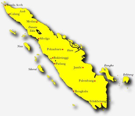
Overview Indonesia's westernmost main island Population: 40 million Area: 473,607 sq km Major ethnic groups: Acehnese, Minangkabaunese, Batak and Malay Each of Sumatra's nine provinces has its own distinctive culture and ethnic group: Aceh, North Sumatra, West Sumatra, Riau, Jambi, Bengkulu, Bangka-Belitung, Lampung and South Sumatra.
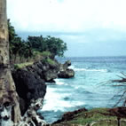
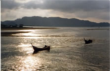
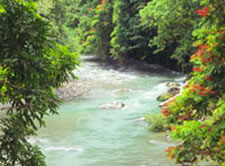
History of Northern SumatraI North Sumatera is a large province stretching from the Indian Ocean in the west to the Straits of Malaka in the East and from Aceh in the North to West Sumatera in the south. It is thick with virgin forests, lush vegetation and jungle covered hills, terraced ricefields, cool mountain streams, strong rivers, beautiful waterfalls, peaceful white sandy beaches and large ancient lakes. The people of the region are hospitable and warm and can be divided into five main ethnic groups; the Coastal Malays living along the Malaka Straits; the Bataks consisting of the sub-tribes of Toba, Simalungun, Pak Pak (Dairi) and Karon of the highlands around Lake Toba and Samosir Island; the Pesisirs of Central Tapanuli along the Indian Ocean coastline; the Mandailings and Angkolas from southern Tapanuli and Nias Islanders off the western coast of the province. Each groups have their own dialects, religious beliefs and traditional arts, customs and culture. There are also several ethnic groups who live in Medan and other towns of North Sumatera, the largest of these being Chinese and Indian. Other parts of the archipelago are represented, but none more strongly than the Acehnese, Minangkabau and Javanese who now live in many parts of the area. As a result, the area is often regarded as constituting a natural museum of Indonesia's proto-Malay heritage in which ancient customs and traditions have been preserved. The diversity of arts and cultures literally make this region a Garden of Eden for social scientists and culture seekers. It is a treasure chest of culture and tradition waiting to be explored, with ancient graves of Batak kings, unique dances and ceremonies, and beautiful arts and crafts. North Sumatera is also one of the riches provinces in Indonesia for flora and fauna with a wealth of birds, butterflies, buffalo and deer. The province proudly boasts its Orangutan Rehabilitation Center in the Gunung Leuser National Park which is bordered by the fast flowing Bohorok River and some delightful countryside and ofcourse Lake Toba, the legendary birthplace of the mountain-dwelling Bataks and the largest inland lake in Southest Asia. The region also produces more than 30% of Indonesia's export commodities. Tobacco, palm oil, tea and rubber are produced in large quantities, particulary around Medan in the north of the province. _____________________________________________________________________________ Geological Background During the early Tertiary, about 70 million years ago, India and the plate on which it lay began to collide with and move under Asia. Its major thrust caused the uplift of the Himalayas, and one of the associated thrusts caused the uplift of the Barisan Mountains that run the length of Sumatra. Movement of the Indian plate under Asia has caused most earthquakes experienced in Sumatra and surrounding areas, including the large quake December 26th 2004, which lead to a devastating Tsunami. Sumatra’s geological past has been characterized by volcanic activity; most recent volcanoes exist in the northern half of the island – Lembuh in Aceh; Sinabung, Sibayak and Sorikmerapi in North Sumatra, providing fertile ground. _____________________________________________________________________________
Present Climate Rainfall in Sumatra varies, dependent somewhat on topography, and ranges from over 6,000 mm per year in areas to the west of the Barisan Range, to less than 15000 mm per year in some areas of the east sheltered by the Barisan Range. Out of 594 rainfall stations in Sumatra, 70% have annual rainfall of over 2,500 mm. The driest months are normally associated with the northeasterly monsoon between December and March, and the main rainy season usually falls during the transition period before the northeasterly monsoon and after the southwesterly monsoon which last from May to September. A secondary rainy period occurs around April which is after the northeasterly and before the southwesterly monsoon. Southern Sumatra, however, has a single pronounced dry season around July, and the northern tip of Aceh has a pronounced dry season in February. 71% of the land area has seven or more consecutive wet months and up to three consecutive dry months. Annual fluctuations in temperature are very small for almost all locations; daily variations are greater during the drier months when the atmosphere is not obscured by cloud cover. Differences in temperature between locations are caused mainly by altitude. Winds generally blow
from the north, December to March, and from the south, May to September.
Where there are breaks in the Barisan Mountains, monsoon winds are channeled
and wind speed may be greatly increased. Angin Depek –
at Air Tawar near Takengon between April and October. This stormy wind
is named after a fish that comes to the surface at this time and is easily
caught.
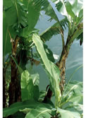
Present Flora For species diversity, the Sumatran forests are comparable to the richest forests of Borneo and New Guinea and are richer than those found on some surrounding islands. Sumatra has 17 endemic genera of plants (compared with 41 in Peninsular Malaysia/south Thailand; 59 in Borneo; and 10 in West Java). The Northern tip of the island is characterized by dominant lowland evergreen forest, montane rainforest, with small zones of semi-evergreen rainforest, and forest on limestone. Vegetation types under the most pressure, such as lowland forest and health forest, are also the richest or most diverse in terms of plant species. Vegetation types under the most threat support the greatest diversity of species. For example, 245 Sumatran bird species live in lowland forest, 158 species in lower montane forest, 62 species in upper montane forest, and only two commonly live in the sub-alpine zone. [Vegetation and Deforestation Maps]
Present Fauna One of the richest islands in Indonesia for animals, Sumatra has the most mammals (201 species) and of its bird list (580 species) 465 are resident and 21 are endemic. New species are still being discovered and recognized. This great wealth is due to the large size of the island, its diversity of habitats, and its past link with the Asian mainland. [List of Nature Reserves on Sumatra] |
RELATED LINKS |
 .... .... |
 ...
... ....
....
 ...
... ...
...