Prepared by Mark Ferry. Identification of Sensitive Areas: A key issue to be considered before beginning a harvest setting layout is to make sure that all sensitive/vulnerable areas are identified and mapped. The types of sensitive/vulnerable areas that need to be found and studied are as follows:
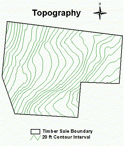
Before discussing the above four issues, a brief description of the harvest design area needs to be outlined. The harvest design area is discussed in detail in the site description section of this report. The harvest design area is located in Township 24/25 N, Range 3 W, which is located near the town of Hoodsport, WA. The sale area is roughly 100 acres in size with predominately moderate slopes. The entire Hoodsport area was heavily logged with railroads 60 - 70 years ago. There are four tree stands located within the planning area. The average diameter at breast height (dbh) for the four stands ranges from 15 - 26 inches. The average tree height for the four stands ranged from 85 - 134 feet. Now that a brief description of the harvest setting area has been described, the discussion of the four-sensitive/vulnerable areas will be described. Topography of the land: The first step in any harvest setting layout is to create a map of the planning area. From our database, we already had a digital elevation model (dem), state land boundaries, transportation coverage, stream coverage, and timber stand data. Next, we used ARC/INFO to clip the above attributes down to fit the planning area on a more reasonable scale. Contour lines were then created from the dem so that ridges, valleys, and steep slopes could be identified. The topography of the planning area was then examined (See Figure 1, below). Slopes of 30 - 40 percent were identified in the top Northwest corner of the planning area. Moving in a Southwest direction across the planning area, a large relatively flat area was encountered. Next, the topography begins to drop off in the Southeast corner. The slope in this area was determined to have a uniform grade of 40 - 50 percent.
Figure 1. Topography for the North Beacon Timber Sale. Contours were created from the DNR DEM.
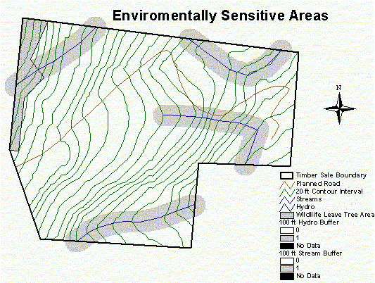
Erosion/Slope/Soil conditions: Within the planning area, there was only one soil type identified from the soil coverage. This soil is named Hoodsport and is described as being moderately well drained gravelly sandy loam. Based on the moderate slopes contained within the planning area, this soil can be considered stable and erosion due to harvesting will be minimal. Environmentally sensitive areas: The identification of environmentally sensitive areas is a key issue in any harvest setting layout. The first step in identifying sensitive areas was to overlay the stream coverage for the planning area. There was only one stream (stream type = 4) in the stream coverage that was within the planning area. Next, two streams were digitized based on the timber sale map provided. The stream that runs West to East in the North portion of the planning area was coded as a type 4 stream and the stream located in the Southeast region of the planning area was coded as a type 5 and 4. Next, 100 foot buffers were created around all streams in accordance with the Department of Natural Resources (DNR) Habitat Conservation Plan (HCP). These buffers were then identified as environmentally sensitive areas that protect and maintain the biological diversity for all living organisms. From the provided timber sale map, a wildlife reserve tree area was digitized and added to the planning area map. This area is located on the West Side of the planning area and runs parallel to the boundary line (See Figure 2).
Figure 2. Identification of environmentally sensitive areas, including streams and wildlife leave tree areas. Other sensitive areas that would have been identified if they were present in the planning area are wetlands and endangered animal habitats.
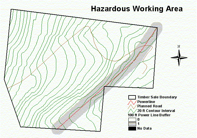
Hazardous working areas: Identification of areas that are potentially hazardous to worker safety is a key issue. Within the planning area was a power line corridor. This was than added to the planning area map by digitizing it off of the timber sale map provided by the DNR. A 100-foot buffer was than created around the power line and was identified as an area of off limits (See Figure 3).
Figure 3. Hazardous working areas in the North Beacon sale consist of a powerline running along the west side of the sale boundary. Back to outline
|


