| Defining the Problem | 1 |
This report is a timber harvest and transportation plan for the northwest portion of the Washougal Landscape (hereby referred to as the Washougal Planning Area), T03N R05E and T03N R06E, WM. It includes designs for road locations, harvest settings, and silvicultural systems as well as support documentation used for making design decisions. These include resource analysis, forest structure modeling and field verification of road and setting designs. This report is provided to the Department of Natural Resourcesí (DNR) Southwest Region as a recommendation for transportation and timber harvesting practices.
Project Objective |
The primary objective of this plan is to establish a road network for the mostly unroaded Washougal Planning Area. This road system will be integrated with the Southwest Regionís level 2A-landscape plan to create a completed transportation system for the entire Washougal Landscape. The secondary objective of this plan is to determine silvicultural treatments that meet commercial timber and spotted owl dispersal habitat objectives discussed in the Habitat Conservation Plan (HCP).
Design Constraints |
In designing a harvest plan, it is crucial to identify the design constraints that will affect management decisions such as road construction and location of harvest units. These design constraints are discussed in greater depth below.
Physical Constraints
The Washougal Planning Area is characterized by deeply dissected mountains. Due to the steepness of the area not only is access limited but there are also slope stability concerns. Since fish habitat and water quality is directly affected by the stability of adjacent slopes, the terrain must be analyzed carefully before making management decisions.
Biological Constraints
The Washington State Department of Natural Resourceís 1998 Habitat Conservation Plan designates the Washougal watershed as a dispersal area for Northern Spotted Owls. Consequently, 55% of the watershed area that could ever support dispersal habitat must satisfy the HCPís dispersal habitat requirements for vegetation inventory and structure at any given time.
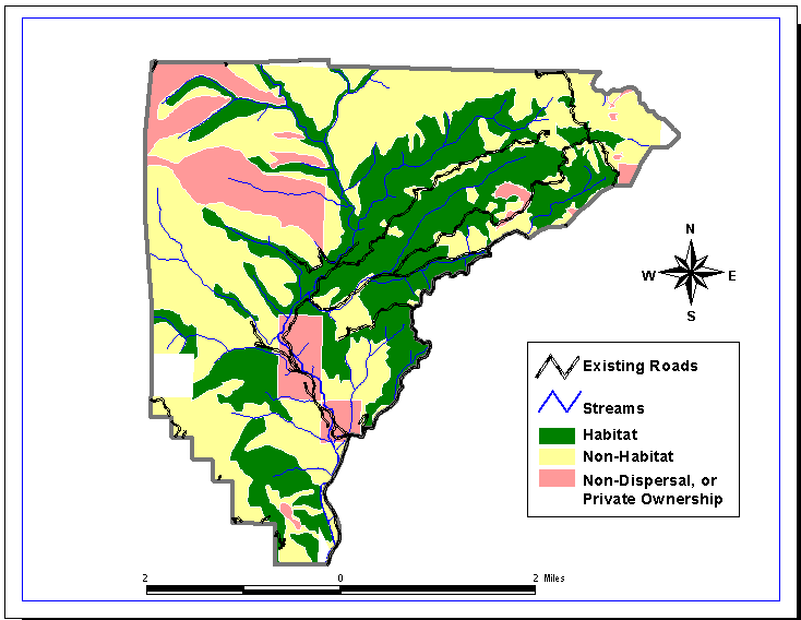
Areas within the Washougal Planning Area are currently classified as either meeting the dispersal habitat requirements (dispersal habitat), not presently meeting the dispersal habitat requirements but potentially satisfying them in the future (dispersal non-habitat), or not currently and never potentially meeting HCP requirements (non-dispersal habitat). This classification was based on a biased 1997 survey in which sample plots were intentionally located in areas most likely to satisfy dispersal habitat requirements (See Figure 1.1). This classification will likely be updated after the FRIS (Forest Resource Inventory System) survey of the watershed is completed later this year.
The dictating factors that produce the HCP requirements for dispersal habitat are relative density index, quadratic mean diameter, height and number of snags per acre.
The habitat mandate set by the HCP will be discussed as it relates to timber resources, growth modeling and silviculture in later chapters.

Figure 1.1 Map of the Washougal Planning Area showing areas of dispersal habitat, dispersal non-habitat and non-dispersal habitat.
Social Constraints
The Washougal Planning Area has been recognized to be politically sensitive. In order to address this issue, documents such as the HCP, the Forest Practices Act (FPA), and the Department of Fish and Wildlife Regulations have been used to guide this harvest plan.
Technical/Equipment Constraints
Harvest practices are constrained by the equipment resources available in the immediate area. This design constraint proved to have little effect on our project, as there is a variety of machinery available in the area. This includes everything from a simple highlead yarder to multi-line machines.