| Road System | 11 |
Field Reconnaissance |
Field reconnaissance was held during the scheduled three-week period, beginning at the end of April and continuing through mid-May, 1998. Weather conditions during this period were variable. The first week was hot, with temperatures in the high 80's; the second week was excellent, with cool temperatures and beautiful sunny days. During the third week, however, it rained daily, making it difficult to accomplish the proposed layout. Occasionally, snow accumulation of a few inches was encountered at higher elevations but this did not deter the students from accomplishing their goals.
The Washougal Landscape is located between private ownership and sparsely populated communities. The difficulty with haul roads includes passage over sensitive slopes, impassible routes, isolated timber stands and easement requirements through private property. Areas with a high possibility of mass wasting, wetlands, streams and rock outcrops were avoided. In addition, planned road lengths were minimized to reduce road density and overall construction. The proposed road design will overcome the existing problems of inaccessibility to areas with timber by connecting new haul routes to the existing County and Forest Services road network system.
Prioritization |
Due to time constraints and the large planned road network, only roads with utmost priority, based on several factors described below, were verified during the fieldwork. Thus, road prioritization was conducted in the following manner:
- Planned mainlines
- Orphaned or abandoned road than can be activated as mainlines
- Terrain conditions
- Spur roads
Planned Mainlines
During the four weeks of preliminary office work, mainlines were designed to access large areas within the watershed. These roads were given top priority during the field reconnaissance since the road network hinged on the feasibility of these roads. Other important routes included roads in difficult terrain as well as those located on private ownership that required easements.
Orphaned or abandoned roads that can be activated as mainlines
Currently there are old snag trails and miner's roads constructed throughout the watershed. These roads were used to fell snags for use of fire logs. Although these roads are located well, they do not comply with present standards because of such steep grades. Besides deterioration of the road prism, most of these roads are in fairly good condition and can easily be reactivated and used as mainlines. Therefore, it will be fairly inexpensive to rectify the grades to the acceptable standards and reactivate these roads.
Terrain Conditions
Although most of the Washougal Planning Area was stable, there were some areas of difficult terrain. In compliance with HCP and Forest Practices guidelines, areas with steep sideslopes, which will cause erosion into streams if disturbed, were avoided.
Spur Roads
For the most part, spur roads were omitted from the field reconnaissance phase of the project. However, a few spurs either on steeper grades or near reconnaisanced mainlines were planned and checked for feasibility.
Road Reconnaissance (Field Work) |
During road reconnaissance, the routes initially laid out on the map were surveyed in the field using one of the available methods:
- Hand compass, clinometer and pacing
- Hand compass, clinometer and Spencer tape
- Electronic Distance Measurement (EDM)
- Global Positioning System (GPS)
The primary means of traversing in the field was by means of a hand compass and pacing, while setting flags at fifty-foot intervals. Azimuths were recorded at fifty-foot intervals whereas left and right slope percentages were recorded at every station. Although this method may seem imprecise and variable, the road location was laid out more efficiently. Rather than pacing, a tape could be used to provide accurate distance measurements but this method was cumbersome and time consuming, thereby slowing down the traverse of the preliminary gradeline process.
The EDM, which is capable of very precise measurement over long distances, uses infrared waves and requires a transmitter at one end and a reflecting prism at the other. The type of EDM used during the road reconnaissance was the Criterion, which provides the horizontal and vertical position of one point relative to another, together with the azimuth, and slope percent. When required, the slope distance can be reduced to horizontal and vertical equivalents by using the slope angle provided by the EDM. The EDM is capable of collecting and processing field data, thereby replacing the field notebook and decreasing note-taking errors. It directly transfers data into TRAVERSE PC, and with some manipulation this data can be downloaded into ROADENG.
The disadvantage of using the Criterion is that it is an extremely sensitive instrument and will provide inaccurate distance measurements if the infrared wave is obstructed by something as fine as a grass blade. Due to the excess amount of undergrowth in the Washougal Planning Area, this method proved to be ineffective for our purposes. The instrument was not only cumbersome to carry on long hikes, but it also took too much time to adequately clear a line of site.
The GPS units that were available, the Trimble Pro XL and Geoexplorer, proved to be ineffective in the Washougal Planning Area. All of the areas received less than the 5 required satellites needed to obtain accurate data.
Gradeline Procedures
While in the field, we set our road gradelines according to what was previously pegged and what was feasible. We used a clinometer to sight ahead for the desired road grade. When laying in grade, there were a few guidelines we followed:
- We kept roads at a minimum grade of 2% and a maximum of 18%, the maximum was only used in extreme cases.
- While running a gradeline through a draw, we kept the grade at less than 5%.
Furthermore, to ensure a feasible grade through switchbacks, we used grades less than 5%, 80ft radius curves and locations where the sideslopes were less than 35%.
Field Marking/Staking
During road reconnaissance, gradeline markings were traversed. When traversing, different flagging colors represented the following:
- Orange for grade location every 50-feet
- When orange was depleted, pink was used. Typically, pink is a preliminary layout that is removed when final location is flagged in orange.
- Blue was used to outline P-line locations and switchbacks
- Yellow/black was used for grade change
- Pink & orange was used for landings
- Each station had the station number, percent grade and date was written on the flagging.
Road Summary Statistics |
Road Grade and Side Slope Statistics
Table 11.1 is a summary of the total mileage for three categories of road grades and three categories of side slopes. The table shows that a large portion of the road is within the desired road grade which is less than 14%. The table also shows that a large portion of road will have to be built on side slopes greater than 70%. More detailed information can be found in the individual road reconnaissance reports (see Road System Report).
Table 11.1 Summary of road grade and side slope statistics
|
Road Grades (%) |
Miles of Road |
Side Slopes (%) |
Miles of Road |
|
|
< 7 |
17.5 |
< 50 |
24.3 |
|
|
7 - 14 |
35.2 |
50 - 70 |
43.5 |
|
|
> 14 |
17.5 |
> 70 |
2.5 |
Road Density Statistics
Table 11.2 is a general overview of the entire road system. It provides a brief summary of road statistics and is broken down into the designated road systems. The information was found using the DNR road coverage and will provide a more thorough analysis of each road system. This table will also be useful in the road construction cost analysis.
Table 11.2 Road Density Statistics
|
Grouse Creek |
Meander |
Miller Gate |
Miner |
Upper Washougal |
2050 |
|
|
Planned (mi) |
14.1 |
10.3 |
18.1 |
12.3 |
13.1 |
5.1 |
|
Existing (mi) |
1.1 |
3.6 |
4.1 |
3.6 |
1.5 |
4.1 |
|
Total (mi) |
15.2 |
13.9 |
22.1 |
15.9 |
14.6 |
9.2 |
|
Area (mi 2) |
4.5 |
2.3 |
3.9 |
2.1 |
2.5 |
1.8 |
|
Planned Density (mi/ (mi 2) |
3.1 |
4.5 |
4.7 |
5.9 |
5.2 |
2.8 |
|
Existing Density (mi/(mi 2) |
0.2 |
1.6 |
1.1 |
1.7 |
0.6 |
2.3 |
|
Total Density (mi/(mi 2) |
3.3 |
6.1 |
5.8 |
7.6 |
5.8 |
5.1 |
|
Number of settings |
100 |
67 |
108 |
78 |
70 |
52 |
The following are the total values for the entire planning area:
- Total Road Density: 4.16 mi/mi2 (219.6 sta/mi2)
- Area of Land Accessed by Roads: 17.1 mi2 (10944 acres)
- Total Planned Roads: 11.5 miles (607.2 stations)
- Total Existing Roads: 69.8 miles (3685.4 stations)
- Total Roads: 81.3 miles (4292.6 stations)
Stream Density Statistics
Table 11.3 is a summary of the road mileage within 200 feet of a stream. It also shows the number of miles crossing a stream according to the stream type.
Table 11.3 Miles of road located within 200 feet of a stream
|
Stream Type |
Existing Roads |
Planned Roads |
Streams Crossed (miles) |
|
1 |
3.8 |
1.9 |
0.4 |
|
3 |
2.1 |
1.1 |
0.3 |
|
4 |
1.1 |
3.1 |
0.8 |
|
5 |
4.0 |
18.5 |
8.5 |
|
Total |
11.0 |
24.6 |
9.9* |
* This number is included in the total number of road miles, 35.6 miles, that are within 200 feet of a stream. This number represents the road length directly associated with stream crossings.
In addition to stream crossings, we found it important to note that 35.6 miles of road is located within 200 feet of a stream. These road sections are scattered throughout the watershed and should be more closely analyzed to reassure that construction will comply with HCP regulations. More detailed information is provided in the individual road reconnaissance reports (see Transportation Report).
Field Reconnaissance Reports |
The following section is a detailed description of the planned road system. It explains the naming convention and gives an overview of each road system. It also includes individual road reconnaissance reports with its corresponding ROADENG traverse and map.
Naming Convention
In order to organize a road plan of such large acreage, we divided the area into six road systems based on obvious landmarks, i.e. one system is accessed by Miller's Gate, hence this system is called the Miller Gate Road System. Each road name begins with two letters, either the first two letters of the landmark, i.e. Mine Creek is the MI Road, or the first two initials of the landmark, i.e. Upper Washougal is the UW Road. Next, there is a hyphen and a number. The first digit of the number was chosen based on the status of the road. This convention is explained below.
- no number – mainline
- 1 – primary
- 2 – secondary
- 3 – tertiary/spur
Finally, roads with an additional hyphen and a second digit are spurs off of the previous road number.
Example: ME-1 This is a secondary road off of Meander Creek Road mainline.
UW-35 This is the fifth spur road off of a Upper Washougal tertiary road.
Due to the large size of the watershed, most spur roads were neither named nor explained in detail. They were, however, verified on the maps and marked as feasible (see Figure 11.1 for an overview map).

Figure 11.1 The Six Major Road Systems within the Washougal Planning Area
Road Accessibility
The topography of the Washougal Landscape can be very restricting. We found that many pegged roads were not feasible. In order to design feasible grades, many roads could not "climb" or descend fast enough to catch ridges or valleys. For example, the following areas were not accessible by roads because of distinct ridge tops that provided grade problems:
Grouse Creek: Section 14, 30 of T3N R5E
Meander Creek: Section 4 of T3N R6E
The areas that could not be accessed by roads, can be accessed by helicopter.
Grouse Creek Road System Overview |
The Grouse Creek road system consists of two major roads, the GR and the MC roads including their spurs. This road system accesses the northwestern part of the Washougal landscape accessing about 2880 acres and stretching for 640 stations (12 miles) (See Figure 11.4 for Grouse Creek Road System Map)
The topography of this area controls the location of most construction. Because of the extremely steep sideslopes that exceed 65% in most areas, ridge locations for road and landing construction are required. These adverse conditions prevent the necessary space required for traditional tower landings on sideslopes to be attained. In turn, road construction costs on steep sideslopes tend to be greater because of the amount of earthwork needed to attain the proper space, which includes major cut slopes, and excavation through rock outcrops. As a rule, any road development in this area should be located on ridges to reduce costs.
The GR road splits from the US Forest Service 502 road in the NE 1/4 of the NE 1/4 of Section 10 of T3N R5E. The road continues in a southeasterly direction following the ridge pattern towards the Washougal River. To use the 502 access road DNR will have to negotiate with the US Forest Service for road share cost, hauling and reconstruction of the abandoned 502 road. However, an advantage to using the USFS road is that the road is already on the ridge system and minimal road construction will be needed on difficult slopes.If access from the USFS road is not feasible, the GR road is also accessible from the south via the MC and GR-1 roads. The MC access road is DNR controlled, so there will not be any difficulty with negotiations or scheduling. The road also contains mostly favorable grades and it is generally a shorter haul. However, the MC road will need some road construction on the sideslopes to reach the ridges, thereby increasing costs.
The MC road starts near the end of the W-2070 road in the SW 1/4 of the NW 1/4 of Section 18 of T3N R6E. The road then crosses the Washougal River, follows Mine Creek and the subsequent ridge system until it connects with the GR-1 road at the SW 1/4 of the SW 1/4 of Section 11 of T3N R5E. The crossing over the Washougal River requires a bridge span of 80 feet and a clearance of 15 feet (see Figure 11.2 and Figure 11.3). The original log stringer abutments are still present and should aid in the relocation and reconstruction of the bridge.

Figure 11.2 Downstream View of Bridge Alternative 1 Where the MC Road Crosses the Washougal River.

During the first 53 stations (1 mile) the MC road follows an abandoned road. The grade of this portion of the road does not exceed 16%. Due to this and the good condition of the roadbed, reconstruction of this segment should be straightforward. Fifteen stations up the abandoned road, a 55-ft radius switchback crosses a type 4 and a type 5 stream. The present crossings are failed box culverts that will need to be replaced. The type 4 stream requires a 20-ft high fill for a usable crossing. The beginning of the proposed MC road calls for the crossing of a type 3 stream. The fill height estimated for this crossing is about 15 feet. The MC road will need to be constructed on steep side slopes and through many rock outcrops or rock faces, which will increase the cost of road.
There are many other roads within the Grouse Creek road system. The MC road has two major spur roads (MC-2 and MC-4). These spur roads access the opposite side of the ridge that the MC road is located on. The GR road has three major spur roads (GR-1, GR-2 and GR-3). The GR-1 road is the access road to the MC road. Other roads that exist in the Grouse Creek road system are the GR-4, GR-5 and GR-6 roads. The GR-4 road, like the GR road, splits from the US Forest Service 502 road at the NE 1/4 of the NE 1/4 of Section 3 of T3N R5E. There are no alternate routes to reach this road. The GR-5 and GR-6 roads access the northern most part of the Washougal landscape and are only accessible by unspecified US Forest Service roads. These two roads are the only access routes to the ridges that they are found on. All of these spur roads are still proposed locations; none of them have been flagged or walked at the present time.

Figure 11.4 Grouse Creek Road System Map Within the Washougal Planning Area
Meander Road System Overview |
The Meander ridge road system taking off from the W-2070 road at the NE ¼ of the SW 1/4 of Section 18 of T3N R6E accesses 67 cable settings and 1472 acres of forestland. It is composed of one main road 243 Stations and one main takeoff 60 Stations flagged (approximately 135 Stations total proposed). We would estimate that this road accesses the most marketable timber at the present time (See Figure 11.5 for Meander Road System Map)
The ME ridge road uses parts of an abandoned road that was constructed in the 1980s. Due to the steep grades encountered and tight curves, parts of the road were not suitable to be used for a haul route. Most notably, the takeoff from W-2070 demonstrates the steep grades climbing the northwest side of the ridge. The abandoned road averages about 25% for 21 stations and there does not seem to be a way to easily correct this situation. An alternate route for climbing up to the ridge was flagged in starting at Prospector Creek Bridge and climbing the southeast side of the ridge, curving around the west tip and climbing the northwest side until it eventually hits the abandoned road again at station 126+00 (see Figure 11.5).
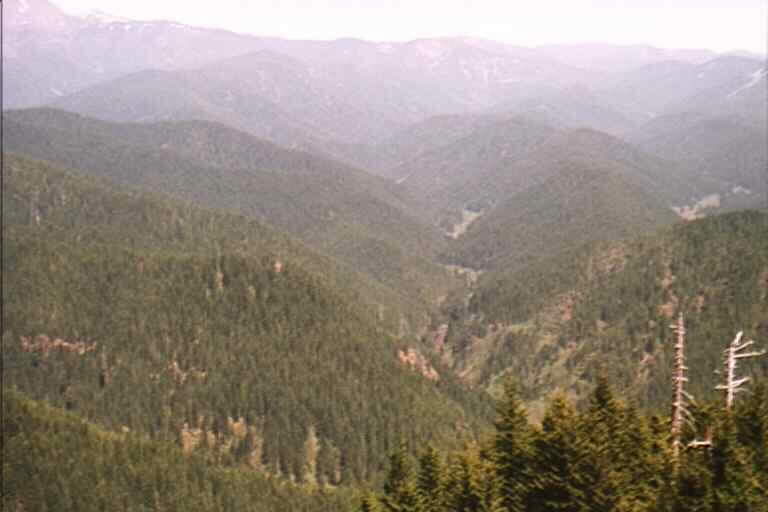
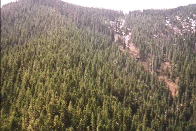
Figure 11.6 Northern headwaters of the Washougal River with Grouse Ridge on the left and Meander Ridge on the right.
A few advantages are to be noted for this alternate route. First of all, the southeast aspect will tend to be a little drier, resulting in lower risk for failure and easier road construction. Secondly, the grades encountered will be adequate to haul logging trucks and other vehicles (16% favorable). This road would be much safer with easier grades and larger radius curves. Finally, the flatter portions of the abandoned road can easily be set up for potential thinning operations.
Along the ridge line, the road travels northeasterly and follows the abandoned road. On occasion, the flag line diverts around a ridge, away from the abandoned road, to avoid steep grades and sharp curves and then rejoins the road. If the grade exceeds 16% for more than 2 stations on the abandoned road, then it is recommended to find an alternate route. If it is steep for less than that, the engineer and contractor can discuss whether or not to cut the ridge top down to grade, or offset the road location by 100 feet or so around the ridge.
The takeoff road beginning at the NE ¼ of the NE ¼ of Section 8 of T3N, R6E, was flagged to access the ridges north of Meander Creek and run southwesterly along the ridge line. This road crosses Meander Creek and another creek that are Type 4 streams at the crossing points. The crossings should be able to use culverts rather than bridges to cut down on construction costs. The flag line stops at the second crossing due to time constraints, but a road can easily be put in up to the ridge line and follow the ridges down to the desired landing locations. There is concern for slide potential on the southeast side of the creek joining Meander (NW ¼ of the SW ¼ of Section 4). Side slopes encountered were steep and wet. Seepage of the hillside was occurring down into the creek. This also causes concern with the second crossing. The flood plain was a 100 feet wide or so and the stream could migrate or flood into the fill bank, where drainage from the hillside has already probably started to saturate the fill. More stable situations would be favorable. It is suggested that an alternate road location and stream crossing be looked into thoroughly before this road be considered for construction. If this road is constructed, geo-textiles or fabric will be required in this area. Also, a retaining wall structure may also be needed to protect from slides.
At the east end of the ME road, at the SW ¼ of SW ¼ of Section 3 of T3N R6E a proposed connector involving two switchbacks is sought to connect to the MC road system to establish a shorter haul route.

Figure 11.5 Meander Road System Map Within the Washougal Planning Area
Miller Gate Road System Overview |
The Miller Gate road system consists of three major roads, the MG, MG-1, and MG-2. The entire road system is located in sections 23, 24, 25, 26, 36 T3N R5E and sections 30, 31 T3N R6E. The road system accesses about 2496 acres and stretches for over 1000 stations (20 miles). The total length of road includes secondary roads and numerous spur roads (See Figure 11.7 for Miller Gate Road System Map).
The entire road system has the advantage of being built in separate stages because of three possible access points. The preferred access location is about ½ mile north of the Miller Gate on the 2030 road. The two alternative take-off locations are on the 1230 road on the east side of the planning area, and the 2014A road at the southern tip of the planning area. However, both the 1230 and 2014A require extensive reconstruction work to bring them up to acceptable haul route standards. This would require negotiations with the property owners because both the 1230 and 2014A are located on private property. In order to avoid right-of-way contracts, cost-sharing agreements, and other provisions, the access point on the 2030 road is recommended.
The main MG road begins approximately 10 stations after the W-2030 road crosses the Washougal River. The take-off point is 100 feet north of a gate that accesses a private cabin. The road begins gradually up the east-facing slope heading in a southerly direction. At station 10+00, the road reaches a flat bench where a switchback and road junction are located. The MG road continues around the switchback and keeps climbing up the slope. The junction with road MG-1 is located at the switchback. MG-1 continues to the south and eventually meets up with the 2014A road and the MG road again. The MG road keeps heading up the slope and continues along the upper portions of the ridge. As the road starts heading south from station 95+00, there is a stretch of unstable ground. This area needs further analysis to verify that a road can be built on this terrain. It is possible that the upper portion of the MG road may have to be built from either the 2014A road or 1230 road because of the unstable area between stations 94+00 and 97+00.
Proceeding past the unstable ground, the junction with the MG-2 road is found at station 108+00. From the junction, the MG-2 road follows the slope contours down to the headwaters of Silver Creek. The MG-2 then crosses the creek and heads up slope and eventually reaches the top of the next ridge to the north. Back at the MG and MG-2 intersection, the MG road continues up the ridge and reaches a switchback at station 115+00. The switchback is located at the southern end of the Silver Creek timber sale. After the switchback, the MG road heads southwest and meets up with a proposed connection with the 1230 road at station 167+00.
To access the 1230 road take-off, the 1230 road must be driven for roughly six miles past a maze of side roads. At the end of the road, a skidder trail goes another 1200 feet around the nose of the ridge. It ends at a saddle where it intersects with the MG. If the MG road needs to be connected to the 1230 road, the proposed connector road will have to be built to avoid the 25% grade of the skidder trail. After the 1230 intersection, the MG road attains the ridge-top and follows it until it intersects a blazed and staked spur road that accesses the South Peck timber sale. Both roads follow the ridge along the upper boundary of the timber sale. In considering the future harvest plan, it is recommended to abandon the spur road and investigate the MG road as a better alternative. After passing the timber sale, the MG road heads down slope until it meets up with the MG-1 road and 2014A road.
The 2014A road is accessed from the 2010 road on private property. The 2014A access point could prove unnecessary if the entire MG or MG-1 roads are built. However, accessing the MG and MG-1 roads from the 2014A road would be a better alternative than the 1230 road. The 2014A road is in much better condition and is most likely a shorter haul route. The MG-1 road heads south towards the junction with the MG road. The area that the MG-1 accesses has the most profitable timber the MG road system has to offer.
The MG road system accesses some of the lower elevations of the Washougal planning area. However the stand conditions vary significantly at each end of the MG road. The first half of the road has many harvestable trees, whereas the second half of the road follows a ridge where no trees are growing (see Figure 11.6).
Figure 11.6 View of the northwest headwaters of Silver Creek, where the proposed MG road will be built.
These diverse conditions may result in only a few portions of the MG road being built. However, building a few portions of the road is better than building random spur roads like the one that accesses the South Peck timber sale. As a result, the MG road system takes into account the entire future harvest plan for the southern portion of the planning area.

Figure 11.7 Miller Gate Road System Map Within the Washougal Planning Area
Miner Road System Overview |
The Miner road system consists of three major roads, the MI, MI-1, and the MI-3 road including their spurs. It access 28 proposed settings and 400 acres of forestland of Section 3, 8, & 10, 15, 16, 17 of T3N R6E. The entire road system stretches for 407 stations. The MI starts in the NE ¼ of Section 15 of T3N R6E, heads north into sections 10,3, and 8 and meets the proposed road for the Miner sale in section 8, and continues on through 17. The MI also ties into Meander road which continues into section 4 (see Figure 11.9 for Miner Road System Map).
This MI takes off from the W-2000 approximately 1900 feet west of the intersection of the W-2000, CG-2000, CG-1440, and CG-2090 and the W-2070. The road proceeds north approximately 28 stations, where it intersects the existing trail (the existing trail begins from the intersection of the W-2000, CG-2000, CG-1440, and CG-2090and the W-2070). This portion of the trail was not field verified, as the DNR had already flagged a similar route. The MI then proceeds north 12 stations along the existing trail. At this point the MI-1 leaves the MI in an easterly direction. The MI continues following the existing trail north for approximately 30 stations. At this point, approximately station 70+00, the MI-2 leaves the MI in a northwesterly direction. The MI leaves the trail and proceeds west for 4 stations where it crosses a draw and heads south. At station 76+50 the MI-3 takes off from the MI to the south. The MI continues southwest around the ridge. At station 82+50 it is continues northerly for 4 stations, then west for 3 stations, then north for about 3 stations where it intersects the existing trail. The MI follows the existing trail for about 4 stations. At this point a connecting road approximately 12 stations in length leaves the MI in a northwesterly direction at about 14% favorable grade to where it joins the ME in the Meander system. The MI leaves the trail at approximately station 96+00 for approximately 22 stations, meeting the existing trail at station 118+00. The MI continues along the trail in a southwesterly direction for approximately 92 stations where it meets the roads in the Miner Sale (see Figure 11.8)
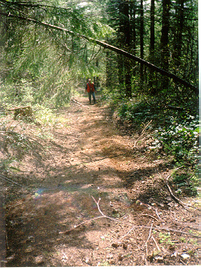
Figure 11.8 Example of an Existing Roadbed Within the Miner Road System.
The MI-1 leaves the MI at station 40 at approximately 14% grade in an easterly direction for 38 stations. At this intersection a spur of about 1000-1200 ft. in length begins. MI-1, then, continues west for about 32 stations where it intersects the MI at station 188+00. Due to time constraints this road was not field verified, however, the map suggests a feasible road location. This road is approximately 70 stations long and accesses 6 proposed settings. The MI-1 crosses one stream and has no switchbacks.
The MI-2 leaves the MI at station 70 in a northerly direction at 16% favorable for 12 stations. At this point MI-21 leaves in a southeasterly direction at 16% for approximately 27 stations. MI-2 continues east at 12%F for 24 stations to a switchback. Then MI-2 heads northwest for 12 stations at 10%F. MI-2 is about 63 stations long. Neither of these roads was field verified, due to time constraints. Although from the terrain map they seem straight forward, the timber volume is unknown in this area. MI-2 accesses 5 settings, crosses 7 streams, and has one switchback. MI-21 accessed 2 proposed landings and crosses 5 streams.
The MI-3 leaves the MI at Station 76+50 heading south for about 12 stations at a grade of 8% Favorable down the hill, switchback around the hill, then northwesterly for about 8 stations at 12%F. The MI-3 switches back across the stream, then south long the stream at 8% for about 19 stations to where it joins the MI-1. The MI-3 is about 47 stations in length and accesses 2 proposed landings, crosses 2 streams, and has 2 switchbacks. Approximately 28 stations were flagged, to the first stream crossing. Across the stream the road parallels the stream, and approximately 10 stations were field verified as entirely feasible. The timber for the first 17 to 18 stations is short, small, and sparse. The timber from station 18 to the stream crossing is very good, trees with 26 to 44 inches DBH and heights of 120-130 feet are frequent. On the westside of the stream the trees are also straight and about 14-17 inches DBH with heights of about 100 feet.
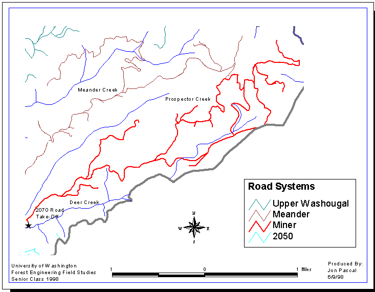
Figure 11.9 Miner Road System Map Within the Washougal Planning Area
Upper Washougal Road System Overview |
The Upper Washougal road system consists of one major road with numerous large and small spurs branching off the major road. This road system accesses the central portion of the northern Washougal landscape. The road extends for a total of 628 stations (11.9 miles) (See Figure 11.10 for Upper Washougal Road System Map).
The topography varies from relatively flat areas to steep sideslopes and reverts to large, flat ridge tops. The soils in this area are stable with few rocky outcrops. The flat ridge tops suggest a good location for a ground yarding system ridge system.
The UW road starts at the end of the W-2070 road in the SE ¼ of the SW ¼ of Section 7 of T3N R6E. Mild reconstruction of the W-2070 road will be required for ten stations prior to crossing the type 3 stream. A bridge will be needed across the Type 3 stream to link the W-2070 to the next ridge. The proposed Upper Washougal road was flagged at 18% all the way to the ridge top. To connect to the next adjoining ridge, a 60-foot radius switchback was designed to cross the Type 4 stream. After the switchback, the grades were reduced to 8%.
Even though the road consists of steep grades when ascending the first ridge, the remaining road system is fairly favorable due to the gentle grades and flatter surface areas. The only deterring factor when laying out the road was the dense shrubbery, but the road construction should be fairly easy and stable. The UW is the main road in this design system, from which various spur roads branch off. It is the only road that accesses this region.
The UW-2 road, which is the next largest road, follows north along the Washougal River for a fairly long distance. Currently the road plan recommends three bridges across the Washougal. Due to expensive bridge construction costs, this may not be a favorable alternative.
The remaining spur roads network along the ridge tops. Since there are no existing orphaned or abandoned roads in the Upper Washougal road system, the construction cost will include hauling the earthwork. . The majority of the earthwork will be on the stretch of road that climbs up to the top of the ridge. The entire road network is located on DNR property, thereby eliminating any easement or sharing difficulties.
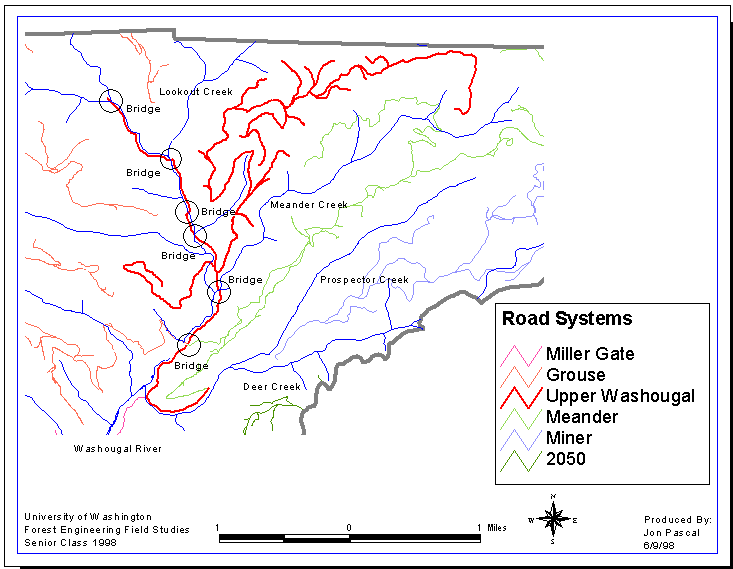
Figure 11.10 Upper Washougal Road System Map Within the Washougal Planning Area
2050 Road System Overview |
This road system is located in the Sections 17, 18, 19, 20, and 30 of T3N R6E. According to the original field maps, there is 5.2 miles of planned road that accesses 52 settings. It consists of two major roads, the W-2050 and the W-2100. Both roads take-off from the W-2000 and terminate in the NW ¼ of Section 30 of T3N R6E, approximately 800ft away from each other on ridge tops. The W-2050 road is currently active and accesses present timber sales. The W-2100 is a proposed mainline for this system. Any other subsequent roads that we added continued along the ridge tops at a reasonable grade. Therefore, due to time constraints, we decided not to conduct a detailed field verification of this road system (See 11.11 for 2050 Road System Map)
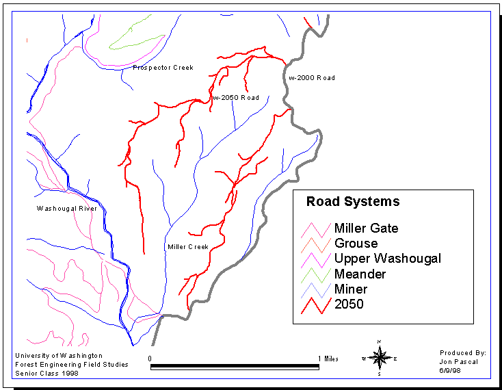
Figure 11.11 2050 Road System Map Within the Washougal Planning Area
Individual Road Reconnaissance Reports*
Grouse Road Reconnaissance
- GR
- MC
- Bridge Alternative 1 (MC takeoff)
Meander Road Reconnaissance
- ME
- ME-1
Miller Gate Road Reconnaissance
- MG
- MG-1
- MG-1-1
Miner Road Reconnaissance
- MI
- MI-3
Upper Washougal Road Reconnaissance
- UW
- UW-1
2050 Road Reconnaissance
No field reports available
*Due to the size of the road reports, an example will be included in this report. For more detailed information including ROADENG data, see the accompanying Transportation Report.
