| Watershed Analysis | 4 |
The watershed analysis portion* was integrated into a 10-week course that was designed as an introduction to the Washougal Planning Area for the FE seniors. Although the analysis was modeled after state guidelines, it is not a formal watershed analysis as it was only intended to provide some preliminary information for this project. The goals of this analysis were: *see FE Senior Watershed Analysis Webpage at
Site Characteristics |
Location
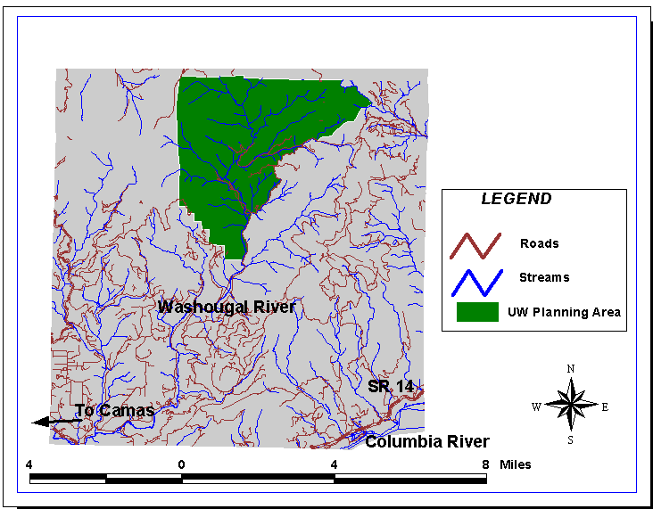
The Washougal Landscape lies in western Skamania County on the south slope of the Cascade Mountains. The Columbia River forms the southern boundary of the landscape area. The eastern boundary of the landscape area joins the Columbia River 5Ĺ miles downstream from the Bonneville Dam and is 4 miles from the town of North Bonneville. The western boundary is 2 miles from the Skamania/Clark county line (see Figure 4.1). This Landscape is one of eleven in the Yacolt Management District.
The Washougal Planning Area is in the northwest portion of the Washougal Landscape. This area resides in Township 3 North, Ranges 5 and 6 East, Willamette (WM). All major drainages within this planning area flow into the Columbia River west of the Bonneville Dam.

Figure 4.1 Vicinity map of the Washougal Planning Area
Climate
The climate of Skamania County, which includes the Washougal Planning Area, is summarized below.
The Coast Range shields the survey area from the severe winter storms moving inland from the ocean, and the Cascade Range protects the area from the high summer and low winter temperatures of eastern Washington. The Columbia River Gorge moderates the blocking effect of the Cascade Range somewhat by allowing air exchange between the inland and coastal areas of the state. Winds in the gorge usually blow from west to east in summer and from east to west in winter. Gale force winds through the gorge are common, especially in winter. (Soil Survey Skamania County Area, Washington, p. 2)
In winter, the average temperature is 39 degrees F and in summer, the average temperature is 65 degrees F. As a result of the factors discussed above, the resulting climate is considered temperate.
Soil Characteristics
The dominant soils found in the Washougal Planning Area are Kinney, Aschoff, Zygore, Andic Cryumbrepts and Dougan (Note: The soil characteristics will be more thoroughly discussed in Chapter 5). According to the DNR coverage, Kinney, Aschoff, and Andic Cryumbrepts can potentially cause erosion problems. Kinney and Aschoff are very deep, well drained soils and are usually found on the back slopes of mountains. On slopes of 30-65%, these soils have a moderate permeability, rapid runoff, moderately high to high water capacity, and a severe hazard of surface erosion. Andic Cryumbrepts is a deep to very deep, well drained soil and is usually found on ridgetops and mountain slopes. This soil has a moderate permeability, medium to rapid runoff, moderately high water capacity, and a severe hazard of surface erosion. (Soil Survey of Skamania County Area, Washington)
Geomorphology
The Washougal Planning Area is characterized by rugged terrain with slopes as high as 90%. The elevation ranges from 300 feet at the Washougal River to 3600 feet in the NW corner of the Washougal Planning Area.
Fire History
The Washougal Planning Area is included in the area that was burned by the 1902 Yacolt fire, one of the largest and most destructive fires in Washington State history. In this fire, 238,000 acres of forested land was burned in thirty-six hours. Other fires that burned through this area include the Washougal fire in 1918, the Rock Creek fire in 1927, the Dole Valley fire in 1929, and the Bear Prairie fire in 1952. Much of the area was reburned when new fires were started by lightning strikes in the standing snags left from the Yacolt fire. Due to these fires, the character of the landscape has been changed drastically soil productivity has been greatly reduced.
Vegetation
The current stand is predominantly Psuedotsuga Menziesii (Douglas fir) with some stands of Abies procera (noble fir) at elevations over 3000 ft. Largely due to the long term effects of fire and the harsh climate, the stands are uniform where the tree growth has been slow since natural regeneration. Many areas have low stocking levels with smaller diameters and heights than expected.
The understory includes Acer circinatum (vine maple), Cornus nuttallii (Pacific Dogwood), Gaultheria shallon (salal), Berberis (Mahonia) nervosa (Cascade Oregon Grape), Polystichum munitum (sword fern), Vaccinium parvifolium (red huckleberry), Rhododendron macrophyllum (Pacific rhododendron), Achlys triphylla (vanilla leaf), and Trillium ovatum (Western Trillium). Riparian species includes Alnus rubra (red alder), Rubus spectabilis (salmonberry), Oplopanax horridus (devilís club), Rubus parviflorus (thimbleberry), and Pteridium aquilinum (bracken fern).