| Slope Stability | 5 |
A mass-wasting event occurs when gravitational force overcomes the strength of the soil materials (Final Habitat Conservation Plan, September 1997). The purpose of this chapter is to provide information on areas that could lead to potential mass wasting events in the Washougal Planning Area. Landslides can be attributed to many factors such as an increase in road construction, surface run-off and a loss of canopy interception. Because of this, it was crucial to analyze a model that shows high-risk areas in the Washougal Planning Area.
Methods |
First, a map was generated using the Shaw-Johnson approach which is the analysis of the hillslide slope and curvature. To do the analysis the Arc/Info program was used. In order to get these results the following command should be typed at the arc prompt:
shawjohnson = con(curve > 0.5, con(slope < 88, 3, 7), con(abs(curve) < 0.5 con(slope < 66, 3, con(slope > 88, 2, 7)), con(slope < 22, 3, con(slope > 44, 2, 7))))
Table 5.1 Shaw-Johnson analysis model of slope and concavity
| SLOPE (%) | |||||
| 0-22 | 22-44 | 44-66 | 66-88 | 88+ | |
| CONVEX | Green | Green | Green | Green | Yellow |
| PLANAR | Green | Green | Green | Yellow | Red |
| CONCAVE | Green | Yellow | Red | Red | Red |
As seen in Table 5.1, the green indicates low risk, yellow indicates moderate risk and red indicates high-risk areas for a mass wasting event to occur. The cut off percentage was placed at every 22 percent which allowed a specific analysis of the more severe areas in the Washougal Planning Area. With this model, a map was then generated to show these high-risk areas (see Figure 5.1).
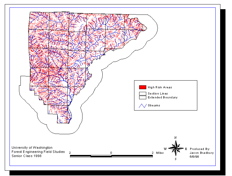
Figure 5.1 Shaw Johnson model highlighting the high risk areas according to slope and curvature
Figure 5.1 indicates that a large amount of the Washougal Planning Area would be considered at high risk for mass wasting. This result propelled a more thorough analysis of the slope stability.
Research |
Several approaches were taken for the analysis of slope stability. These different approaches will be discussed in the following section.
Aerial Photos (1968 and 1993)
Aerial photos were first used to analyze the current conditions of the area. Duye to time constraints, the analysis was only performed on the areas most at risk to mass wasting which was found in the central western portion of the Washougal Planning Area. This analysis was used to pinpoint areas when past mass wasting events occurred. Due to the numerous fires in the area, these events would give an indication of the effects that a disturbance such as harvesting would have on the slope stability. The photos that were used are listed below.
T3NR5E, Section 24
Flight path 72, photo # 54, 55
T3NR5E, Section 23
Flight path 72 photo # 56, 57
T3NR5E, Section 13
Flight path 73, photo # 58, 59
T3NR5E, Section 14
Flight path 73, photo # 60, 61
T3NR5E, Section 12
Flight path 74, photo # 57, 58
T3NR5E, Section 11
Flight path 74, photo # 59, 60
There were several areas found that showed evidence of sliding activity. These could have been caused by a past mass wasting event but they could've also been caused by roadside casts, road cuts, and excess sediment due to streams merging together. These results were then verified during the field verification phase which will be discussed in more detail later in this chapter.
The 1993 photos were harder to analyze since it had more vegetative cover. The photos that were looked at were:
T3NR5E, Section 24
Flight path 96, photo # 71
T3NR5E, Section 23
Flight path 95 photo # 96, 97
T3NR5E, Section 13
Flight path 96, photo # 72, 73
T3NR5E, Section 14
Flight path 95, photo # 98
DNR Soil Coverage
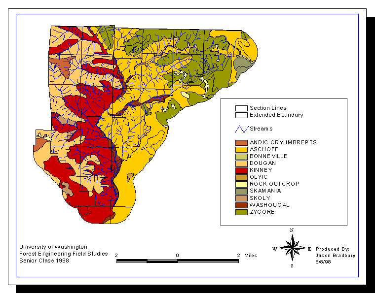
According to the DNR soil coverage, the soil type Kinney has a high water capacity and the soil type Aschoff has a high erosion potential. According to the Soil Survey of Skamania County Area, however, these two soil types are also categorized by slope classes. When these two soil types are found on slopes of 30-65%, they will both have a high water capacity and severe erosion hazard. Based on our fieldwork, it seems reasonable to assume that these areas are indeed on these steeper slopes. So with this in mind, it is unclear how useful the DNR soil coverage is as there seems to be discrepancies with the data.
Soil Name
Figure 5.2 is a map of the different types of soils in the Washougal Planning Area. The three main soil types that are discussed in this analysis are Kinney, Andic Cryumbrepts, and Aschoff. The other soils do not have any characteristics that have the potential to cause mass wasting.
Slope Stability
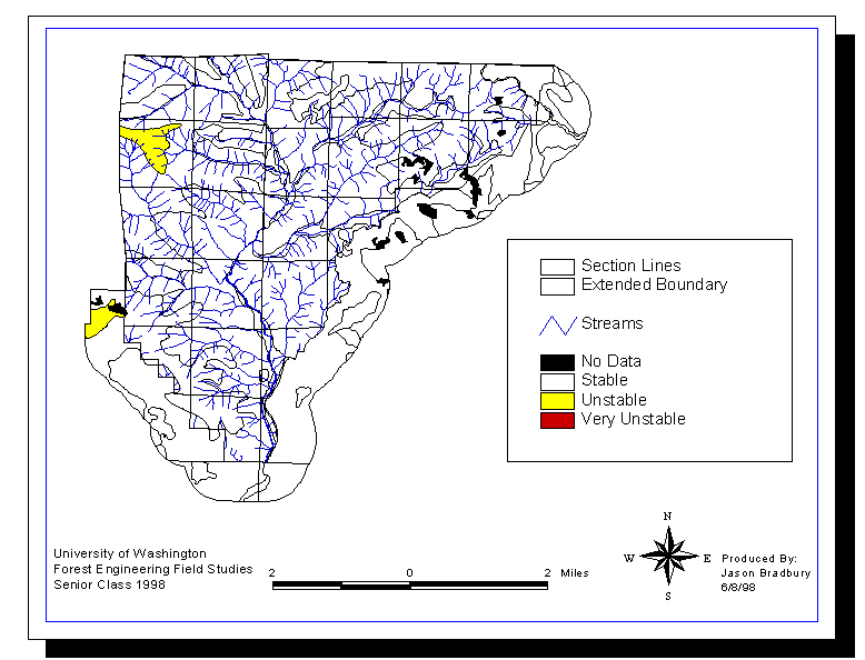
Figure 5.3 is a map showing areas according to its stability. This map seems to contradict the results shown in the Shaw Johnson analysis (Figure 5.1). Figure 5.1 implies that the majority of the Washougal Planning Area is at high risk for slope failure. According to Figure 5.3, the majority of the Washougal Planning Area is considered stable. Obviously, these two maps are using very different parameters in completing what would seem to be a similar analysis. Due to the lack of metadata, it is unclear what exactly Figure 5.3 means.
Water Capacity
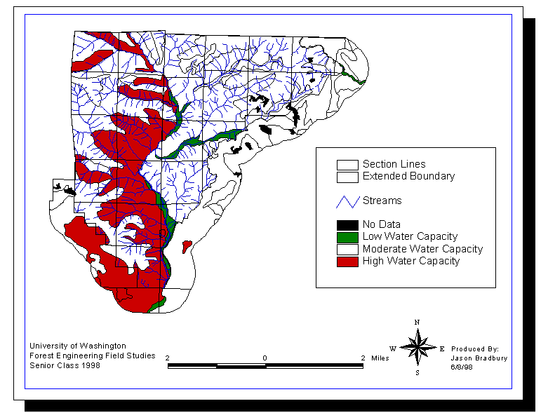
Figure 5.4 is a map showing areas according to its water capacity. This map shows that the areas dominated by the Kinney soil type have a high water capacity. This is corroborated by the description given in the Soil Survey of Skamania County. It is unclear what the indications of a high water capacity are. On one hand, more water storage would mean less overland flow which would imply less surface erosion. On the other hand, more water storage would mean wetter soil conditions which would imply a higher chance for a major slope failure. Without more information about the parameters of this data, the results of this map are inconclusive.
Erosion Potential
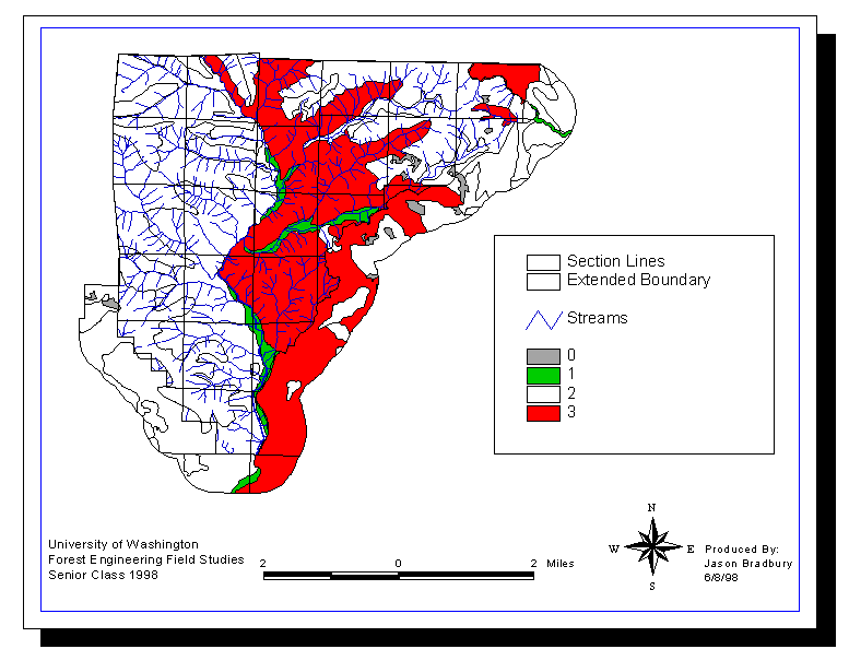
Figure 5.5 is a map showing areas according to its erosion potential. This map shows that the areas dominated by the Aschoff soil type have an erosion potential rating of "3". It is unclear what the values given in the legend are. These were undefined in the coverage that was analyzed. For this analysis, we assumed that a rating of "3" was a high erosion potential as this corroborated the soil description of Aschoff in the Soil Survey of Skamania County.
Results |
Figure 5.1 has a lot of red high hazard areas that seem reasonable. The terrain in our planning area is steep and rugged. There are a lot of streams in this area also. Most of the red high-risk areas are right along the streams which are narrow and engraved into the hillside. We then had to verify these findings and look for past evidences of slope failures. We did this by looking at the 1968 and 1993 Aerial Photos, Land Satellite Imagery Map, and Ortho Photos. The 1968 photos gave me a good look at the area. The photo was taken after a forest fire had gone through and the vegetation was now growing up. This gave us a good look at what this area would look like after a harvesting and with the semi-exposed ground. We were able to look at the slope failures with more ease than the 1993 photos where the vegetation is more densely populated. The Land Satellite Imagery gave us a map that we just used to see if a slide was in that area. This map shows different levels of vegetation densities. Like the 1993 aerial photos, the Ortho Photo's had a high density of forest cover, which made it hard to see if there were any slope failures. By looking at the different soil maps you can see that it is hard to tell why the whole planning area is considered stable or why it is considered high water capacity only one side of the Washougal River. This soil data did not help us much in the analysis with the Shaw Johnson model. Conclusion??? Or Results???????? However, we conclude that when building roads we need to stay on the ridge tops as much as possible. We have a greater chance of slope failure when on the side hills but even greater chance when you are close to the streams. The Shaw Johnson model shows this as high risk areas which indeed should be treated as so. But, doing field verification where these roads will be placed we only found a few places that should be looked at further. References Krogstad, Finn. Personal Interview. April 2, 1998 , April 7, 1998 , April 13, 1998 Jarros, Weikko. Personal Interview. April 6, 1998 , April 13, 1998