| Timber Resources | 6 |
Data |
Timber stand information for this project was obtained from DNR GIS coverages, timber sale information, DNR interviews, habitat survey plot cards, and field reconnaissance.
GIS data included the POCAL layer, the soils layer, the DEM (Digital Elevation Model), the LULC (Land Use Land Cover) table, and the current dispersal habitat layer (see Chapter 3 for a detailed description of the DNR layers). These layers contained information such as stand boundaries, site indices, vegetation type, aspect, slope and elevation. After three weeks of field work in the planning area, it was apparent that most of the information in these layers was inaccurate or outdated. Only the topographic information in the DEM (slope, aspect and elevation) and the vegetation breaks reflected in the habitat coverage (HCP defined areas) were considered reliable.
Table 6.1 Description of GIS Coverages and their usefulness
|
GIS Coverage |
Useful Contents |
Status |
|
DEM |
Elevation, aspect, slope |
Good |
|
Pocal |
Stand boundaries |
Irrelevant |
|
Soils |
Site index |
Inaccurate |
|
Lulc table |
Vegetation info |
Outdated |
|
New Dispersal |
Habitat info |
Good |
Due to the inaccuracy of the available data, inventory plots were taken during the field portion of the project in order to supply some realistic timber data. Due to the limited time available for timber cruising, only a single transect of double-sample variable radius plots were taken (a total of 24 plots). Data from these plots was used to develop representative diameter and height distributions. This data was then adjusted to reflect expected volumes in different areas of the watershed based on current timber sale information (Miner Sale), DNR interviews, aerial photos, and UW field reconnaissance. Forest Resources Inventory System (FRIS) data is presently being gathered for the Washougal watershed. The FRIS data should supercede the inventory data developed for this project once it becomes available.
Site Index |
The Washougal Landscape is characterized by a rugged terrain with well drained soils and high wind forces. These conditions result in low growth rates, high taper, and thick underbrush. As previously stated, the long fire history has converted the timber cover into uniform age and species stands.
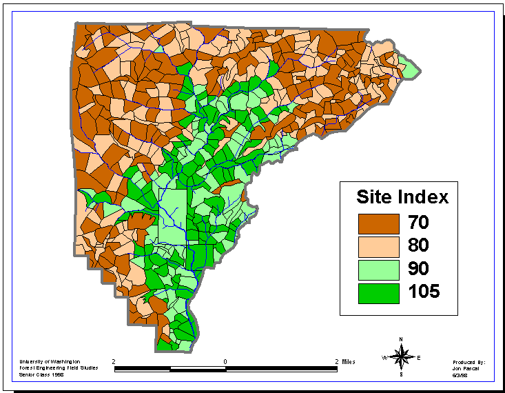
Field verification of site index data contained in the soils layer revealed that soil productivity was far lower than expected. On average, actual site indexes appeared to be 20 – 40 units less than those reported in the soils layer. Field reconnaissance and aerial photography indicated that the most significant vegetation breaks in the watershed were based on aspect and elevation. Northwest facing slopes tend to be better protected from winds, tend to retain moisture longer than do south facing slopes, and therefore tend to be the better growing sites. Higher elevations within the watershed are the most exposed to the elements and tend to be the fastest-draining areas. The extreme conditions of the watershed exaggerate normal vegetation changes due to elevation. For example, Douglas-fir does not appear to grow above 3000 feet. To account for these variations in site conditions, site indices were assigned based on the general aspect (SE and NW) and elevation (above or below 1750’) of each setting polygon (see Figure 6.1).
Due to the uniform nature of the timber across the watershed, stand boundaries were set to follow the setting boundaries created within PLANS (Chapter 12). These setting boundaries were created based on hillside breaks which corresponded to site index changes. See figure 6.1 for the stand boundaries as they relate to site index.

Figure 6.1 Planning Area Site Index According to Setting Boundaries. Indices are based on aspect (north or south facing slopes) and elevation (above or below 1700 feet)
After creating stand boundaries, identification codes were assigned by adding the unique Arc/Info polygon id to a category code. For example, 70,000 was added on to all habitat polygon ids to create a new stand number. These codes were based on setting boundaries, management history, habitat classification and severe vegetation differences. This process gave all polygons a unique id while ensuring that the different categories would have similar site condition attributes and identical timber inventories. The table below shows the seven unique categories.
Table 6.2 Description of Stand ID Numbers
|
Polygon Type |
ID Number |
|
Clearcuts/Sales |
10,000 + polygon-id |
|
Riparian Buffers |
20,000 + polygon-id |
|
No Ownership |
30,000 + polygon-id |
|
Bare |
40,000 + polygon-id |
|
Non-Dispersal Non-Habitat |
50,000 + polygon-id |
|
Dispersal Non-Habitat |
60,000 + polygon-id |
|
Habitat |
70,000 + polygon-id |
Vegetation attributes were then added to the unique categories. The vegetation attributes were based primarily on field reconnaissance averages and DNR interviews.
HCP Discussion |
The Washington State Department of Natural Resource’s 1998 Habitat Conservation Plan designates the Washougal watershed as a dispersal area for Northern Spotted Owls. Consequently, 55% of the watershed area that could ever support dispersal habitat must satisfy the HCP’s dispersal habitat requirements for vegetation inventory and structure at any given time.
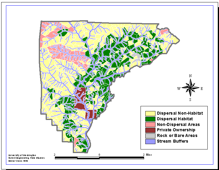
Areas within the Upper Washougal planning area are currently classified as either meeting the dispersal habitat requirements (designated as dispersal habitat), not presently meeting the dispersal habitat requirements but potentially satisfying them in the future, such as mid-slope with site indices under 100 (designated as dispersal non-habitat), or not currently and never potentially meeting HCP requirements, such as rock outcrops or high ridges (designated as non-dispersal habitat) (see Figure 6.2). This classification was based on a biased 1997 survey in which sample plots were intentionally located in areas most likely to satisfy dispersal habitat requirements. This classification will likely be updated after the FRIS (Forest Resource Inventory System) survey of the watershed is completed later this year.
HCP requirements for dispersal habitat are as follows:
- Relative Density Index > 50 (this is used to approximate a canopy closure of 70%)
- QMD of 100 largest trees > 11 in
- Height of 40 largest trees from above diameter class > 85 ft
- 3 large snags per acre
There is an abundance of large snags throughout the Washougal as a result of the Yacolt burns. It was assumed that this requirement was fulfilled and no further analysis was preformed.
Riparian Buffers |
In addition to the habitat classifications, the FPA (Forest Practices Act) specifies that all typed streams must have riparian buffers. These buffers must be 100 ft on type 4 and 5 streams, and 100 feet or the tree height for the adjacent 50-yr site index (if larger than 100 feet) on type 3 streams. Until the Riparian Management Zone plan is finalized, there are currently no harvest options available within these buffers.

Figure 6.2 1998 HCP habitat classification map for the upper Washougal watershed
The habitat classification only considers area and not the disproportional amount of volume within the areas, reflected in Table 6.3. The riparian areas have the highest percentage of volume in the watershed which is currently inaccessible. Red alder composes about 40% of the riparian stands. This volume is not included in the current conditions table (see Table 6.4), however it is included in the percentage volume in the table below (Table 6.3). Although alder will not grow more than about 60 feet, the large DBHs will create a high relative density. The site indeices for the riparian areas will encourage height for the Douglas fir. Therefore, riaperian areas will always meet the dispersal habitat requirements. This alone may justify a reevaluation of the current riparian management zone restrictions.
Table 6.3 Percentage of area vs percentage of volume for habitat classification
|
% Area |
% Volume |
|
|
Riparian Buffers |
27 |
33 |
|
Dispersal Habitat |
23 |
31 |
|
Dispersal Non-Habitat |
38 |
30 |
|
Non-Dispersal Non-Habitat |
12 |
6 |
Current Stand Conditions |
In general, the upper Washougal watershed is an area with harsh site conditions that severely impact productivity. The following table is a summary of current statistics for the various stand types.
Table 6.4 Current Stand Characteristics
|
Stand Characteristics |
Dispersal Habitat |
Dispersal Non-Habitat |
Riparian Buffers |
|
Area (%) |
23 |
38 |
27 |
|
Average DBH (in) |
9.8 |
7.9 |
9.5 |
|
Average Height (ft) |
79.9 |
70.5 |
73.5 |
|
TPA |
279 |
325 |
444 |
|
Volume/Acre (bdft) |
26,949 |
15,570 |
23,821 |
The current stand characteristics only represent vegetation information found in the dispersal area. In order to approximate vegetation attributes for non-dispersal areas a new updated bare coverage was created and these areas were removed from the non-dispersal regions. All other non-dispersal areas were assigned the same attributes as the dispersal non-habitat areas.
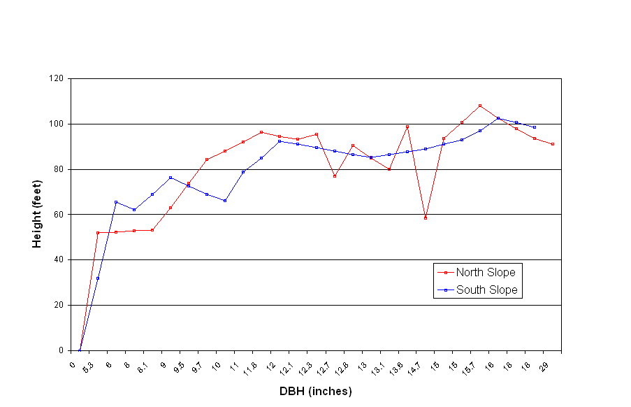
Overall, the timber has low heights for the associated diameters. The following graph shows the unusual relationship between height and DBH that is consistent throughout the planning area. The average tree within the unit will gain no height after a 9.5 inch DBH. The stunted height is an indicator of the high wind shear within the unit. The average tree does not grow higher than 80 feet, the protected height of the entire stand. This relationship poses a problem within the HCP guidelines. The habitat requirements within HCP states that 40 of the largest trees must have a height of at least 85 feet. Because the heights within the Washougal average under 80 feet, this is likely the parameter that will make habitat most difficult to achieve. This problem may force the state to reevaluate the HCP criteria relating to tree heights on a specific regional basis.

Overall, the harsh characteristics of the Washougal landscape such as steep slopes, well drained soils, dense underbrush and high winds have caused the planning area to have low site indexes, growth rates and volumes. The entire planning area is uniform due to a consistent fire and passive management history. In order to increase productivity in this bleak area, active management must take place.