
Geology-
The tsunami was caused by a “mega thrust” earthquake that occurred when stresses were released as the India plate was subducted beneath the overriding Burma plate. The India plate begins to descend into the mantle at the Sunda Trench, which lies to the west of the earthquake’s epicenter. The depth of the ocean is around 4,500 meters.
The India plate moves toward the northeast at a rate of 6 cm/year, which results in an oblique convergence at the Sunda Trench.
An estimated 600-mile-long rupture occurred along the seafloor as one fault slid past the other, much like seismologists expect the San Andreas Fault to do in California. It is likely that the average displacement on the fault plane was about fifteen meters. The sea floor overlying the thrust fault would have been uplifted by several meters as a result.
According to the press spokesman of the Meteorological and Geophysical Office in Jakarta, Indonesia, the epicenter was about 41 miles off the coast of Sumatra and about 16 miles below the surface of the ocean and well beneath the ocean floor. Several aftershocks followed the main earthquake, as of 1:00PM, MST, December 29; sixty-eight aftershocks had been cataloged. The largest occurred about three hours after the main shock and was assigned a magnitude of 7.1. Thirteen of the aftershocks have magnitudes of 6.0 or larger. There have been no reports of tsunamis being generated from the aftershocks.
The energy released by the earthquake was described as 475,000 kilotons of TNT by the USGS, a force equivalent to 23,000 Hiroshima bombs.
WHAT HAPPENED ON DECEMBER 26, 2004
0058 GMT (0758): A severe earthquake occurs under the sea near Aceh in Northern Indonesia, generating the tsunami. The epicenter is located in the Indian Ocean, 150 miles northwest of the island.
The first reports concerning the magnitude of the earthquake are contradictory. While the Indonesian authorities report a reading of 6.6 on the Richter scale, United States geologists report a figure of 8.1. The US authorities later report a more accurate measurement of 9.0, making this the largest recorded earthquake in 40 years since the 9.2 earthquake of Prince William Sound, Alaska in 1964.
[NOAA's 3D Simulation of the tsunami on December 26, 2004]
The following are the approximate time that the tsunami hit each region. Local time is listed in parenthesis.
~ 0115 GMT (0815): waves 30 ft high hit Sumatra and Aceh province
~ 0130 GMT (0830): Andaman Islands
~ 0230 GMT (0930): Thailand
~ 0300 GMT (1000): Sri Lanka and South India
~ 0430 GMT (1130): Maldives (3/4 of the capitol city becomes submerged underwater)
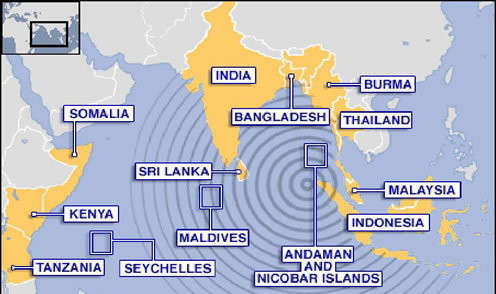
~ 0800 GMT (1500): Coastline of east Africa and Somalia
click on county's name to view aerial photo (source: BBC World News)