Introduction:
 |
Circulation plays an important role in maintaining consistent water quality throughout Puget Sound. It is not simply a stagnant pool of water, but a flow between the fresh water input of the rivers at the surface and the deep saltier seawater from the coast. The three dominant mechanisms affecting circulation patterns are tidal currents, density which is a function of salinity and temperature and local and remote wind patterns. Winds along the coast periodically cause upwelling, bringing in denser ocean water to flush out the estuary (Duxbury 2001).
The contributions of freshwater and seawater can be seen by studying depth profiles of water properties near the San Juan Islands. These islands receive large amounts of freshwater input from the Fraser River, as well as seawater input from the Straits of Juan de Fuca. It is an ideal sampling location to observe circulation patterns at work (McManus 2005).
The San Juan Islands are settled in-between the Strait of Juan de Fuca and Georgia Strait. Circulation patterns flush huge amounts of freshwater from the Fraser River through the Georgia Straits and San Juan Islands in the Strait of Juan de Fuca. As freshwater travels along the west side of San Juan Island through Haro Strait it mixes with deep, saltier waters from the Pacific Ocean. The mixing of freshwater and saltwater layers in Haro Strait occurs due to the sills at the North and South ends of the narrow channel (Gerdes 2000).
Previous research has focused on nutrient inputs and mixing patterns through Haro Strait along with biologic productivity and diversity of the surrounding marine waters. However, very little research has focused on the physical oceanography in the San Juan Channel, which also contributes to the mixing of freshwater from the Fraser River estuary. The San Juan Channel is one of three channels that connect the Strait of Georgia to the Pacific. Previous research shows a well mixed water column within the San Juan Channel where stratification does not persist (Gerdes 2000).
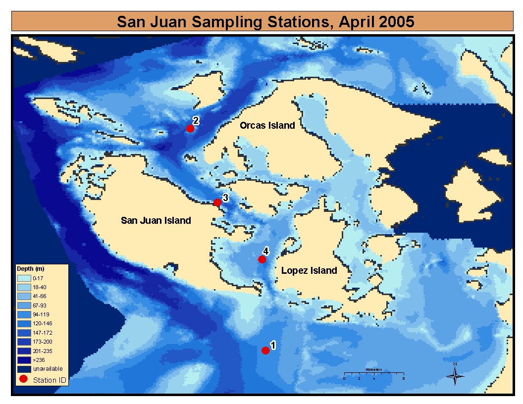
The Water Resources and Pollution Course at the University of Washington contributes to previous research and data collection. Our objective was to create a transect through the channel to gain a greater physical understanding of this system and observe the mixing of freshwater input from the Fraser River with seawater from the Pacific. See the map below for locations of sampling stations and the following table for latitude and longitude coordinates.

| Landmarks | Latitude | Longitude | Depth (m) | |
| 1 | Strait of Juan de Fuca | 48.38455 | -122.954 | 104.8171 |
| 2 | N. San Juan Channel | 48.65227 | -123.045 | 112.3171 |
| 3 | Friday Harbor | 48.563 | -123.012 | 134.4512 |
| 4 | S. San Juan Channel | 48.49427 | -122.958 | 108.8415 |
The goal of this website is to provide public access to data collected during our two day sampling expedition near the San Juan Islands, eventually accumulating a historical record of water quality parameters in this area. An overview of field sampling methods, results and discussion are also present, as well as a data repository presenting actual data collected.
Duxbury, A.C. and A.B. Duxbury. 2001. An Introduction to the World's Oceans (4th ed.). Iowa: Wm. C. Brown Publishers.
Gerdes, F. 2000. Flow, stratification and mixing in San Juan Channel. Retrieved from the Coastal and Estuarine Geophysical fluid dynamics web-page May 2005: http://pulson.seos.uvic.ca/people/gerdi/friday_harbor/friday_harbor.html
McManus, M., P. Donaghau and T. Osborn. 2005. Large-scale physical forcing of thin layer dynamics. Retrieved May 5, 2005: http://www.onr.navy.mil/sci_tech/ocean/reports/docs/po/03/pomcmanu.pdf
Friday Harbor Labs
Department of Ecology, Marine Water Quality Data
NOAA
Acknowledgements
Thanks to the crew of the Centennial Research Vessel and Deb Sklar for web page development advice.