Browse Exhibits (77 total)
Block 9 Topography
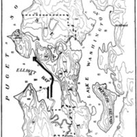
I struggled a lot with this site report because at first I could not find a lot of good or interesting information about my block. Being completely residential it at times feels very boring, but this week I decided to look at the bigger picture of why my block needs to be residential. In order to be residential the land had to be evened out to build on but was not once a mountain that was chopped down nor does it sit on top of the Montlake Landfill like some parts of the University District do (apparently only 3 feet of soil are technically required to go over it which I found mildly disturbing). My block shows both old small homes, and apartment buildings leaving me wondering “why is so much housing necessary?” As I looked back at topographic maps of Seattle I found that without the 58 regrades done in areas around my block it never would have been possible or necessary for the housing on my block to exist.
Once I realized this I shifted my focus to be more on this element of Seattle looking more into the changes made so that transportation became easier and Seattle was able to spread out during this time. As it became easier to move around businesses and the population alike were able to move deeper into Seattle into areas like my block. So although my block had no huge change, the other large changes like Denny and Beacon Hill, or Pioneer Square opened the door for population growth stimulating the need for the city’s expansion and higher density housing became necessary. Of course the second the regrading happened was not simultaneous with the building of my block’s housing as that was started in the early to mid 1900s, but it does have a cause and affect relationship.
Site Report 2

I struggled a lot with this site report because at first I could not find a lot of good or interesting information about my block. Being completely residential it at times feels very boring, but this week I decided to look at the bigger picture of why my block needs to be residential. In order to be residential the land had to be evened out to build on but was not once a mountain that was chopped down nor does it sit on top of the Montlake Landfill like some parts of the University District do (apparently only 3 feet of soil are technically required to go over it which I found mildly disturbing). My block shows both old small homes, and apartment buildings leaving me wondering “why is so much housing necessary?” As I looked back at topographic maps of Seattle I found that without the 58 regrades done in areas around my block it never would have been possible or necessary for the housing on my block to exist.
Once I realized this I shifted my focus to be more on this element of Seattle looking more into the changes made so that transportation became easier and Seattle was able to spread out during this time. As it became easier to move around businesses and the population alike were able to move deeper into Seattle into areas like my block. So although my block had no huge change, the other large changes like Denny and Beacon Hill, or Pioneer Square opened the door for population growth stimulating the need for the city’s expansion and higher density housing became necessary. Of course the second the regrading happened was not simultaneous with the building of my block’s housing as that was started in the early to mid 1900s, but it does have a cause and affect relationship.


