|
Click on the question mark to ask the class about oceanography, Glacier Bay, or the cruise. Your question and answer will appear on the Questions page under Quick Links. |

|
10:30 PM March 18
Ship Tours and Stepping Foot in Alaska!
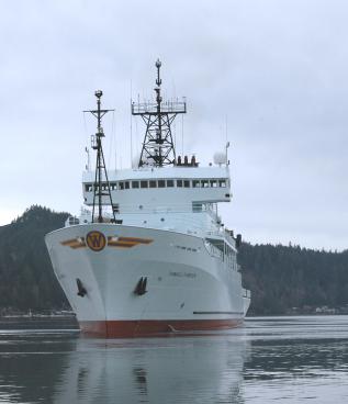
Glacier Bay! We finally made it! After 4 days of traveling, our ship finally docked in Bartlett Cove this morning. Students from high school and elementary school greeted us and they were able to come aboard and take a tour of the ship. The group Aubrey, David, April and I had were the youngest kids so they were really excited to just be on a real ship. We took our group to the labs, bridge, galley, TV room, and berthing areas. None of us had actually been up to the bridge for awhile so we had to pretty much guess which doors to walk through. Anyway, the tours for the most part went very well and the kids left us a bunch of cards wishing us a fun and exciting trip.
After all of our guests were off the ship, it was our turn to go outside and play. Getting off the ship was one of the best feelings—especially after yesterdays wave of seasickness that hit our group. The ground was covered with snow that unsurprisingly brought on an intense snowball fight. There was even a small beach area where we could walk down and touch the water and believe me, that water was WAY colder than anything in Puget Sound. A few minutes later, we had to end our fun onshore and head back to the ship, but the little time we did spend in Bartlett Cove was an amazing experience that led to the buildup of more excitement as we move up the Bay.
-Carmela
6:30 AM March 19
Birthday’s at sea… Happy birthday to instructor Kathy Newell…
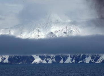
After we left the NPS dock yesterday we cruised north towards our first stations in Glacier Bay. At first the day was flat and gray, and we couldn’t see any of Glacier Bay’s legendary scenery.
As we moved deeper into the bay the fog slowly lifted, revealing breathtaking mountains and distant glaciers. Today we will move closer to the head of the glaciers in Tarr inlet (see the map under “Where are we today” at left).
The midnight-8 AM crew is wrapping up a long, cold night of CTD casts, cores, and plankton tows. Some students have been up for 24 hours or more, as they try to adjust their plans to accommodate changes in the ship’s schedule. Many of the stations will be reached earlier than expected (planning this way is standard for scientific cruises, and buffers against time that is sure to be lost at some stations).
Jasper’s project, for example relies on sampling zooplankton at a given depth. However zooplankton the world over undergo a diurnal (daily) vertical migration. Some species migrate up toward the sunlight in pursuit of prey during the daytime. Other species migrate down away from predators during the daytime. Reaching stations several hours early means that a given species, or even the majority of a given trophic level may not be present at the planned for depth.
Jasper and others with time sensitive projects must monitor the ship’s progress closely, and continually update their sampling plans.
Today is sure to be a busy day, stay tuned as we bring you updates and some detailed information on the techniques and equipment being used by the science party.
1:00 PM
The various projects being undertaken on the Glacier Bay cruise can be roughly broken into four sub-disciplines; biological, chemical, physical, and geological oceanography. There is much cross over between these subdisciplines, and usually it is necessary to share data and information between groups to obtain a comprehensive understanding of a single problem.
The tools used by the four groups differ considerably, and range from the low tech hand-deployed plankton tow to high end sonar and drifters. The tools that we are applying to Glacier Bay are briefly described here.
Plankton Tow: This tool is fairly specific to biological oceanographers. One of the simplest and most effective techniques for sampling zooplankton and larger phytoplankton. The plankton tow is a fine-mesh net (the mesh ranges in size from 300 micron to less than 30, depending on the net and its application) designed to be dragged through the water. Any plankton that is not small enough to escape through the mesh gets concentrated down into a collection jar.
Since plankton concentrations (particularly zooplankton) can be low, this is an effective means of obtaining a usable concentration of organisms. A researcher can calculate the volume of water sampled from the diameter of the net opening and the distance the net was dragged. The downside is that the plankton tow is not specific to a depth. To sample a given depth you have to sample everything between that depth and the surface.
Sediment Trap: Sediment traps are used primarily by biological oceanographers, but the data collected are very useful to chemical and oceanographers and marine geologists. Sediment traps collect falling organic and inorganic matter (these two fractions are usually separated in the laboratory). From this the sedimentation rate and particle flux to the deep sea (or estuary) can be determined.
CTD (Conductivity, Temperature, Depth): CTD’s have been in use for many years now, and are still a fundamental tool of biological, chemical, and physical oceanography. The CTD is an instrument package that can measure the salinity (through conductivity), temperature, density (through a salinity/temperature calculation), depth, oxygen, and chlorophyll concentration. As if that’s not enough, the instrument package is surrounded by large “Niskin” bottles that can be closed (“fired”) remotely from the control station. This allows researchers to obtain water samples on demand, from any depth sampled.
The CTD is tethered to the ship by a long cable. The Thompson carries enough cable to sample to a depth of almost 30,000 ft. This is deeper than all but the deepest ocean trenches. The CTD is monitored from a control station in the Thompson’s computer lab. When it is deployed the CTD provides a vertical profile of all the measured parameters throughout the water column. This makes it very easy to see trends and patterns that have a horizontal orientation (such as one water mass overriding another).
Box Core: Almost everyone in oceanography is interested in mud (sediment, as marine mud is called). Biological oceanographers want to know who lives there, chemical oceanographers want to know what chemicals those organisms contribute to the water column (and therefore the atmosphere), marine geologists and physical oceanographers want to study the layering and structure of the sediment. The end result is that oceanographic research vessels collect a lot of mud.
The box core is a popular coring method when a large amount of mud is required from a relatively thin layer (a couple of feet into the seafloor). The large device pictured at left is lowered by crane onto the seafloor, and sinks by weight into the sediment. When the device is pulled upright, a large shovel arm swings below the box to seal the sediment sample.
Kasten Core: When studying sequence stratigraphy (sediment layering) is the primary objective or a deeper sediment sample is required, a Kasten core is used in place of a box core. The long Kasten core is lowered onto the bottom where it inserts by weight into the sediment. The sediment is retained within the corer by suction.
VanVeen Sediment Grab: The VanVeen sediment grab is a very low tech, clam shell style shovel that can be lowered to the seabed. It is a great, fast way to sample the sediment when composition is important but structure is not.
Drifters: Physical oceanographers are primarily concerned with where water goes and why. In days gone by they employed “drift cards” to identify currents, literally dumping many thousands of index cards (computer punch cards were popular) and seeing where they ended up.
Today we use higher tech drifters, electronic (and in some cases even autonomous) drifters that report their position by satellite. This allows for the retrieval of the instrument and a much more complete data set. We have deployed a number of drifters near the mouth of Glacier Bay. After an allotted amount of time has passed we will search out and recover the drifters.
Acoustic Doppler Current Profiler: Another way of measuring current is with sonar. One of the Thompson’s several sonar tools measures current.
Bottom Sounding Sonar: Virtually all oceanographers are interested in the layout of the seafloor, known as bathymetry (seafloor shape has a direct impact on current and habitat). Determining bathymetry is usually the task of marine geologists and physical oceanographers. The Thompson uses several different sonar types to map the surface of the seafloor, and beneath the surface of the seafloor (between 10 and 70 meters). In its current configuration the Thompson can produce high resolution bathymetric images in water as deep as 5,000 m (15,000 ft).
Putting it all together: The beauty of the oceanographic cruise is that all of these instruments and specialized researchers are forced into close proximity for a long period of time. You wouldn’t be able to avoid integrating ideas and results even if you wanted to (and of course, everyone wants to integrate their ideas). Results on scientific cruises are disseminated to the entire science party, only the analysis is “owned” by a researcher or research team.
-Jeff
|
|
March 19, 2008 |

|
Quick Links
Senior Thesis Research Course, Ocean 444
Senior Thesis Planning Course, Ocean 443
Quick Links to Blog Entries
|

|
Some of Glacier Bay’s legendary scenery peaks out from behind the fog. |

|
Students ready a VanVeen sediment grab for deployment while the CTD sits on the deck. The CTD is one of the most widely used oceanographic tools, and will be deployed at almost every station we visit. |
|
Dan hoses down the deck after deployment of the box core (behind him and two the left). The frame supports the box core, which can be seen in the center of the structure. |

|
Brandon and Justin remove predetermined layers (usually every 1-2 cm) of sediment from a Kasten core. |

|
Chase prepares drifters for deployment. |

|
Interface for the echosounder, which penetrates 10-70 meters into the seafloor. |


|
Andy makes it happen on the CTD early this morning. |
|
Glacier Bay banner background image by Andy Cameron, see original image. Send mail to: seniorcruise2008@ocean.washington.edu |