
Location: Fiji
Coordinates:
16o 35' 23" S Latitude
179o 24' 22" E Longitude
(approximations)
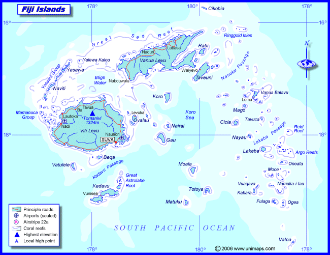
The Republic of the Fiji Islands, in the southern Pacific Ocean, is located approximately 3,100 km northeast of Sydney, Australia, and approximately 5,000 km southwest of Honolulu, Hawaii. It is made up of about 330 islands along withïn about 500 more tiny atolls, islets, and reefs. The islands cover a total land area of 18,270 km2. The main islands, Vitu Levu and Vanua Levu, accounts for 87% of the total land area and contains most of the population and economic acitivity.
There are various towns that exist all over the country on many islands but there are two main cities are Suva and Lautoka. Suva is the capital of Fiji, located on the southeast coast.which is the largest urban center in the South Pacific besides Australia. Lautoka is the second largest city, centered on the west side of Viti Levu.
Topography
The topography of Fiji is similar to most island in the South Pacific. This islands as shown on the map are mostly volcanic in origin with a large number of the smaller islands being formed build up of coral deposits. Fiji has some of the largest mountains in the island countries in the South Pacific with the highest peak being Mount Tomanivi in the center of Viti Levu at 1324 meters. The larger islands of Viti Levu, Vanua Levu, Taveuni and Kadavu have a number of mountains ranges with fertile files and rolling hills. The rest of the land mass in Fiji is comprised of small volcanic and coral islands with only 16% of the land is suitable for agriculture
Geography
Fiji's geography comprises a group of volcanic islands in the South Pacific lying about 4,450 km. (2,775 mi.) southwest of Honolulu and 1,770 km. (1,100 mi.) north of New Zealand. Its 322 islands range in size from the large--Viti Levu (about the size of the "Big Island" of Hawaii, and where Suva and 70% of the population are located) and Vanua Levu--to much smaller islands, of which just over 100 are inhabited. The larger islands contain mountains as high as 1,200 meters (4,000 ft.) rising abruptly from the shore. These islands also have a diverse range of terrestrial ecosystems, including extensive areas of indigenous forest. The high islandshave distinct wet and dry sides due to prevailing wind patterns. Coastalecosystems include mangroves, algae and sea-grass beds in shallow reef andlagoon areas, and various reef types such as barrier, fringing platform and atoll or patch reefs.
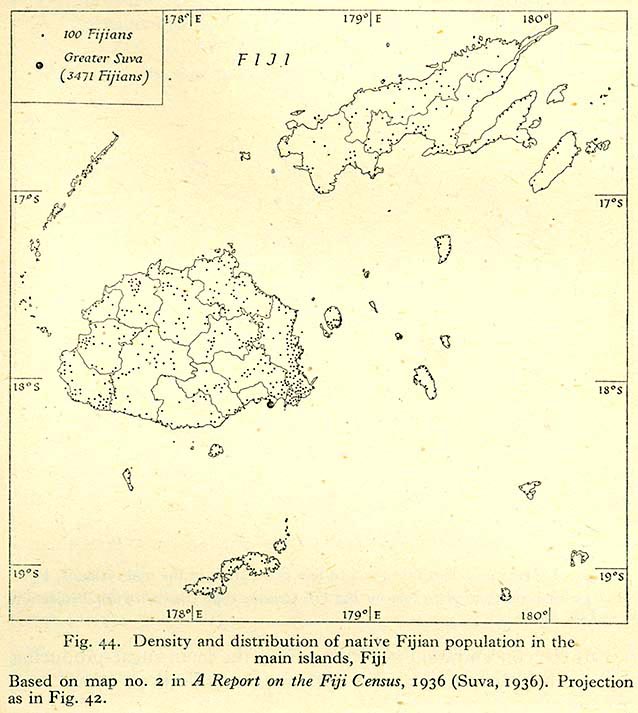
This is a thematic map of Fiji's population distribution, which is showing the various concentrations of people spread across the county with the highest concentration in the city of Suva, the capital of Fiji.
Climate
Subtropical and tropical climates exist in Fiji. Rainfall is highly variable and strongly influenced by topography, with the prevailing south-east trade winds bringing moisture onshore and causing heavy showers in the mountain regions. The wet season is from November to April and results from the southerly movements of the South Pacific Convergence Zone. The wet season is characterised by heavy, brief local showers and contributes most of Fiji's annual rainfall. Annual rainfall on the main islands is between 2000mm and 3000mm on the coast and low lying areas, and up to 6000mm in the mountains. The smaller islands receive various amounts according to their location and size, ranging from 1500mm to 3500mm.
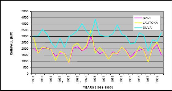
The graph shows the average rainfall over a span of 29 years. As you can see. The variation between years is pretty low and remains fairly stable in between 1000mm and 3000mm. The year of 1975 seems like the only time when rainfall peaked at 3500mm for Lautoka and at 4400mm for the city of Suva.
Along with the tropical climate patterns are the occurances of Cyclones within in certain areas of Fiji. Cyclones are mostly confined to the period November to April, with greatest frequency in January and February. On average, some ten to fifteen cyclones per decade affect some part of Fiji, and two to four do severe damage. The dominant north-west to south-east tracks gives some increased risk of damage in the outlying north-west island groups.
Last modified: 5/25/2007 4:40 PM