Results and Discussion
|Home| |Introduction| |Materials
and Methods| |Results and Discussion| |Links|
|References|
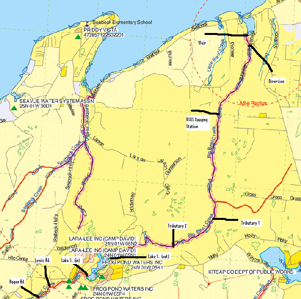
As mentioned earlier there were nine different sites conducting studies at the same times on the same day. This specific study involved the Lake Symington inflow and outflow sites. The other seven were two in the upper farm, marshland region, two tributaries in the middle region between Lake Symington and the lower region, one at a storm gauge in the lowland region, and two in the lower watershed at the diversion site and weir site. Site data and locations can be viewed in the following tables and map. 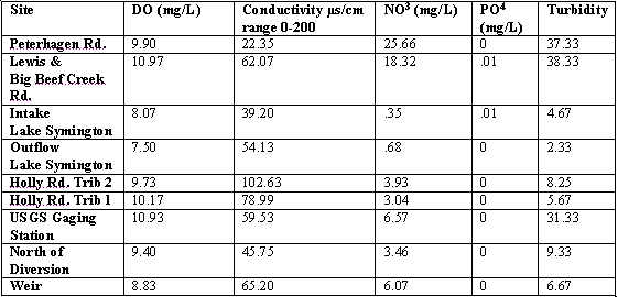


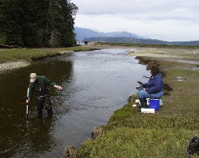
On April 19,2003 at 11:30am at the Lake Symington outflow the following observations were documented. The location is at latitude: 47° 35.937'N, longitude: 122° 49.466'W at 390ft. above sea level. The air temperature was 17° Celsius, the barometer read 29.98in.Hg, and there was no observable wind. It was slightly sprinkling with overcast skies. The land use in the surrounding area was largely residential with housing throughout entire area. There was a wooded area on the East side of the creek. There was a large concrete urban dam and fish ladder upstream from our position. The Riparian zone vegetation consisted of salmonberry, blackberries, ferns and a largely alder tree forest on East side of river with a few Douglas Firs interspersed. The substrate was mixed with small pebbles, mid sized cobbles, to large boulders. It should also be noted that there was a 100ft. high cliff that was badly eroding on the East side of the stream. There was some woody debris interspersed throughout the streambed. The water was a tea color that may represent tannin. There was next to no canopy cover in this section of the stream. Local residents had built a rock wall up to the stream channel. No wildlife was observed besides hearing a few birds and 4 young men throwing rocks at the eroding cliff.
Also on April 19, 2003 but at 3:40pm we arrived at the second site on the Lake Symington inflow. The second site was located at latitude: 47° 35.598'N, longitude: 122° 50.213'W at 433ft above sea level. The air temperature read 17° Celsius, the barometer read 29.86in.Hg, with no observable wind. It was somewhat sunny with a little cloud cover. The land use in the surrounding area consisted of 1 store, 1 house, and a paved road with a large culvert for the stream to go through. This section of the stream was mostly wooded. The riparian zone vegetation consisted of blackberries, ferns, and salmonberry. The surrounding forest consisted largely of Alder trees with Douglas Firs, and some Western Red Cedar trees. The area had about 50% canopy cover. The substrate consisted of many mid-sized to large cobbles and a few boulders. There was woody debris within this section of the stream.
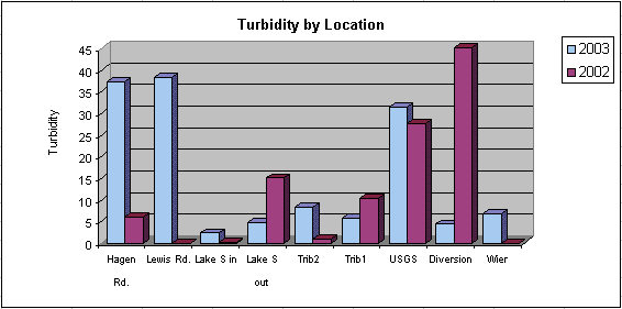
The Big Beef Creek watershed has not yet been affected by urban development and the added sediment runoff has yet to build up in the streambed. This watershed is essentially a pristine environment for the wildlife that it supports. Our turbidity readings tell us the amount of suspended particles within the streams water. Our readings are well below water quality standards to support a healthy functioning watershed.
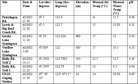
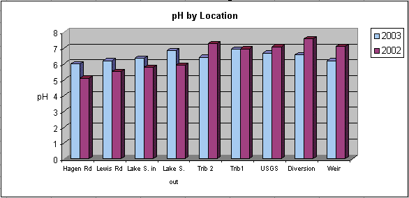
Public water supplies have water quality standards that set by the Public Health Service and are between pH6.5-8.5. Big Beef Creek watershed falls comfortably within those margins. Most of the watershed has pH values that are even better than the standards set for drinking water. This is a good sign for the many freshwater critters living within the watershed. As shown in the following graph the highest acidic areas are located within the middle region of the watershed. The acidity increases on either side of Lake Symington and the tributaries. The reason for this increased acidity is inconclusive but may be the small farms and cattle in the upper stretches of the watershed. The lower region may be receiving more runoff than the middle region.
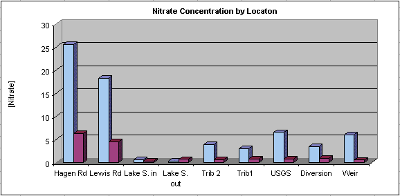
The nitrate concentration has a noticeable spike in the upper regions of the watershed as noticed on the graph. It is likely that the small farms and cattle in this region contributed to these abnormally high numbers. Several cows and livestock were observed in the upper regions of the watershed, which is likely the source of the high nitrate concentration. The nitrate concentration at the Lake Symington inflow and outflow site barely registers on the Vernier. As the stream continues downstream the concentration slightly goes up, which may be due to fertilizers and pesticides.
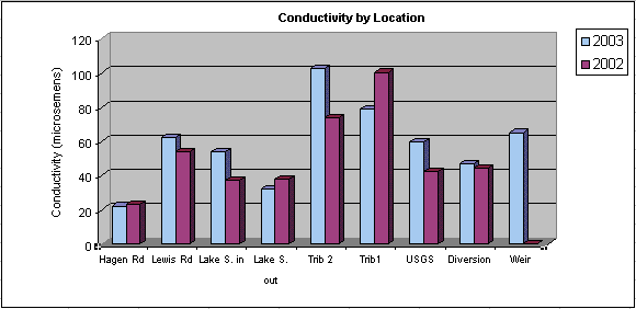
Conductivity is a measure of the amount of dissolved ions within the streams water such as chloride, nitrate, sulfate, phosphate, sodium, magnesium, calcium, iron and aluminum. As shown in the following graph, Trib 2 has the highest conductivity readings, which may be due to runoff from Holly Rd. Other possible contributors are the human element that lives all around this region of the watershed. However, these readings are well below sustainable water quality standards for supporting freshwater organisms.
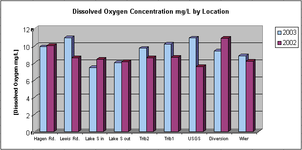
Dissolved oxygen is also a common indicator of a healthy stream or watershed. The dissolved oxygen concentration helps to sustain many freshwater organisms that require a certain amount to survive. The concentration recorded throughout the Big Beef Creek watershed paints an idealized picture for all watersheds. This likely is occurring due to the dam turbulence at its base. As water is frothed up it is more susceptible to absorbing more oxygen. Other fluctuations are possibly due to water temperature variations throughout the watershed. Data is in the following graph.
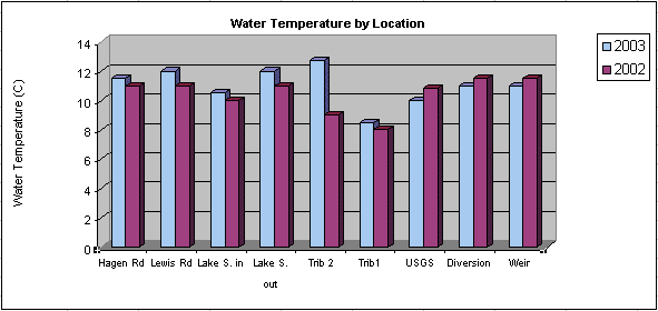
Water temperature is an important component for most freshwater organisms. Notice the temperature rise in the following graph from the inflow to the outflow in Lake Symington. While the water rests in the lake it warms up 1.5degrees Celsius, which a dramatic change for sensitive freshwater organisms.
The Big Beef Creek watershed has not yet been affected by urban development and the added sediment runoff has yet to build up in the streambed. This watershed is essentially a pristine environment for the wildlife that it supports. Our turbidity readings tell us the amount of suspended particles within the streams water. Our readings are well below water quality standards to support a healthy functioning watershed.
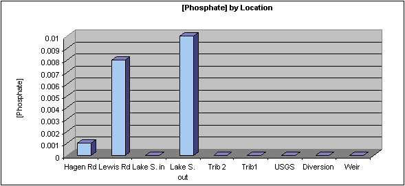
Inorganic phosphate is good indicator of a watersheds health. Excessive amounts
of phosphate can cause excessive plant growth. The data that was collected for all sites
visited were so small as to barely register in the spectrophotometer and some data read
zero.
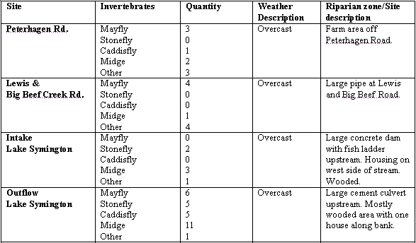
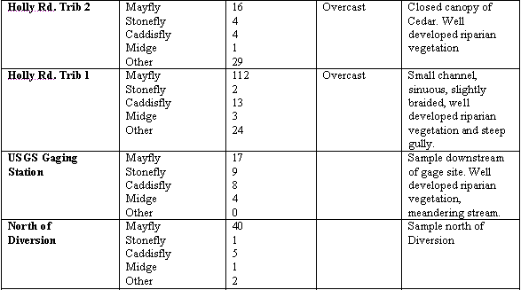
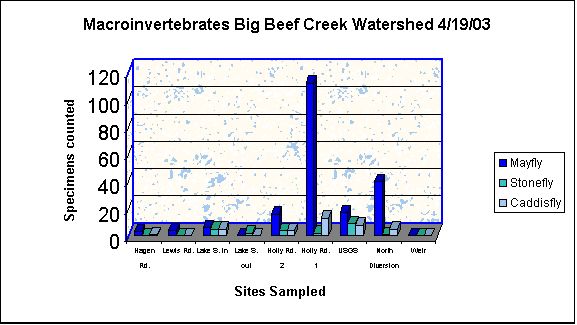
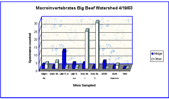
Macro-invertebrates may be the most conclusive measurement about the health of a stream. There are two types of macro-invertebrates pollution tolerant and pollution intolerant. Pollution tolerant macro-invertebrates are midges, black flies, and worms. Pollution intolerant macro-invertebrates, which we found at Big Beef Creek, are mayflies, stoneflies, and caddis flies. Throughout the watershed the mayflies were conclusively the most abundant of the macro-invertebrates.
The Big Beef Creek watershed has a lot of positive readings that identify the stream as being very healthy and in near pristine condition. Big Beef Creek watershed is a largely rural environment that is being encroached by some development, so there is reason for concern. A watershed of such health needs to be preserved for future generations to enjoy its beauty. The stream appears to have some problems in the upper regions but it appears to clean itself out along the run into the Hood Canal.
 BBC Home
Web site constructed by Chris Ringstad, Deb Bailey, and Jeffrey Elisoff, June 2003