 |
Abbreviation Key for Sampling Activities:
|
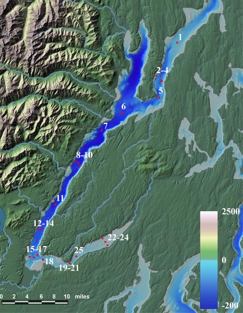
Station |
Latitude |
Longitude |
Depth (m) |
Landmarks |
Sampling Activities |
1 |
47°47.916N |
122°42.400W |
49 |
Sill |
CTD, O, C, N, P, G |
2 |
47°44.376N |
122°46.165W |
10.4 |
Bangor West |
CTD, C, O |
3 |
47° 44.083N |
122°45.167W |
112 |
Bangor Center |
CTD, O, C, N, G |
4 |
47° 43.289N |
122° 44.885W |
11 |
Bangor East |
CTD, O, C, G |
5 |
47° 41.162N |
122°45.915W |
106 |
Hazel Point |
CTD, O, C, N |
6 |
47° 39.490N |
122° 52.062W |
138 |
Calibration Point |
CTD, O, C |
7 |
47° 37.114N |
122° 56.217W |
174 |
North Holly |
CTD, O, C, N, P |
8 |
47° 33.398N |
123° 01.281W |
26.5 |
W Hama Hama |
CTD, O, C |
9 |
47° 32.836N |
123° 00.488W |
143 |
Hama Hama Center |
CTD, O, C, N |
10 |
47° 32.343N |
123° 00.123W |
13 |
E Hama Hama |
CTD, O, C |
11 |
47° 28.609N |
123° 04.447W |
162 |
N Dewatto |
CTD, O, C, N |
12 |
47° 25.512N |
123° 07.565W |
10.5 |
Bam Ban West |
CTD, O, C |
13 |
47 °25.280N |
123° 06.852W |
123 |
Bam Ban Center |
CTD, O, C, N |
14 |
47° 25.241N |
123°06.091W |
11 |
Bam Ban East |
CTD, O, C |
15 |
47 °22.462N |
123° 08.770W |
9.4 |
Potlatch West |
CTD, O, C, |
16 |
47° 22. 250N |
123° 07.916W |
80.2 |
Potlatch Center |
CTD, O, C, N, P |
17 |
47° 22.651N |
123° 06.877W |
12.6 |
Potlatch East |
CTD,O, C |
18 |
47° 21.757N |
123° 06.064W |
33.1 |
Potlatch South |
CTD, O, C, N, P |
19 |
47° 21.404N |
123° 01.560W |
6 |
Sisters North |
CTD, O, C |
20 |
47° 21.395N |
123° 01.412W |
51.7 |
Sisters Center |
CTD, O, C, N |
21 |
47° 21. 293N |
123° 01.146W |
4.8 |
Sisters South |
CTD, O, C |
22 |
47 °24. 375N |
122° 55.965W |
8.2 |
Lynch North |
CTD, O, C |
23 |
47° 23.898N |
122° 55.698W |
17.4 |
Lynch Center |
CTD, O, C, N |
24 |
47° 23.459N |
122° 55.062W |
6.2 |
Lynch South |
CTD, O, C |
25 |
47° 22.268N |
123° 00.492W |
33.5 |
ORCA Buoy |
CTD, O, C, N, P |