Introduction to Geographic Information Systems in Forest Resources
| Introduction to Geographic Information Systems in Forest Resources |
|
|||||||||||||||||
|
|||||||||||||||||
Discussion
This demonstration will show the more common use of GPS technology in gathering data for a GIS. The hardware used for this demonstration are a Trimble GeoExplorer (handheld) and a Trimble ProXL (backpack). Software is Trimble PFinder Office Version 1.1 for Windows.
Pre-planning
Data capture
Differential correction
Export to GIS format(s)
Import to GIS
GPS Navigation
Pre-planning is one of the most important steps in any GPS survey. Because the satellites vary in their position during the day, DOP changes continuously. Sometimes, the topography of a study site can also create interference that can degrade data.
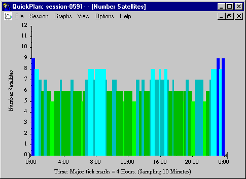
Number of Satellites
The first step is to see if enough satellites will be visible during mission time. If fewer than 4 satellites are visible, 3D measurements are not possible.
This chart shows the number of satellites potentially available during the day. Remember that some satellites can be hidden by buildings, trees, or landforms. Therefore, some possible down time will be at about 2:30 AM, 6:15 AM, 11:20 AM, and so forth.
DOP
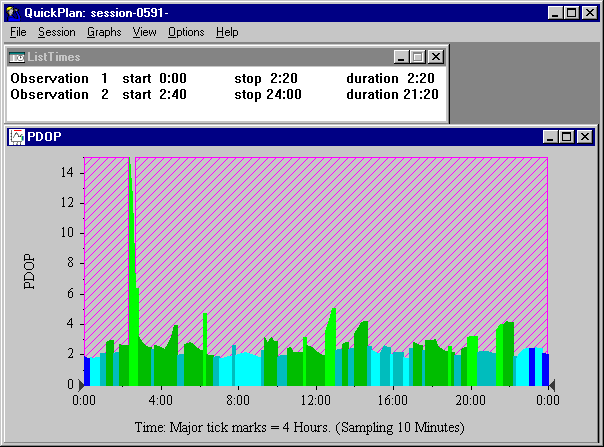
If enough satellites are visible, the next step is to see if the geometry of the satellites will give low DOP. We can set a mask in the software to show good and bad times during the day. Here, we have set a mask based on at least 4 satellites visible, and a PDOP below 7. As you can see, at about 2:00 AM (2:20 to 2:40 AM, to be precise), there is a dramatic spike in PDOP. The software shows times that are good in a hatched pattern, and bad times in a clear pattern. In addition, a list of times is generated.
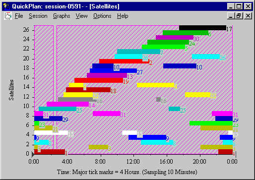
Satellites
The planning software will also generate a chart showing the satellites, with the times they are visible:
Furthermore, we can plot the satellite positions in the sky with a few other charts:
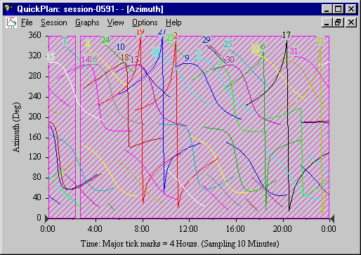 |
Azimuth Displays the compass position of the satellites through the day. |
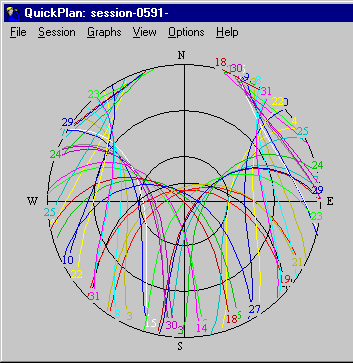 |
SkyPlot Displays the trajectory of each satellite on its path. |
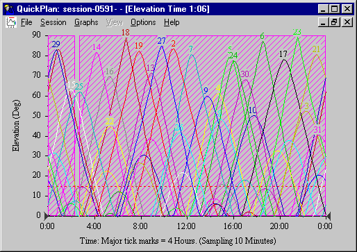 |
Elevation Shows the elevation of each satellite through the day. |
Landform curtains
If we know something about the landform, we can create landform curtains to refine the mission planning process.
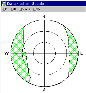
In this example, if we were in a very steep sided, north-south oriented valley, we would miss the satellites at their eastern and western extremities. After the curtain has been created, it changes the times of the day for optimal data collection.
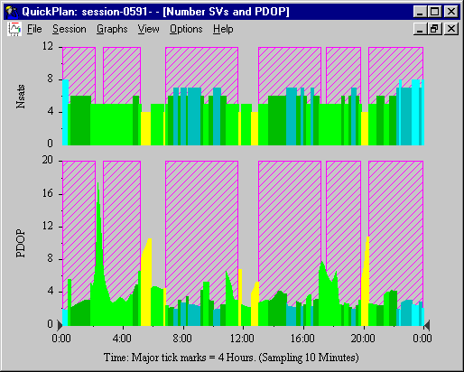 |
The number of satellites and PDOP now shows more times of day that are not suitable. |
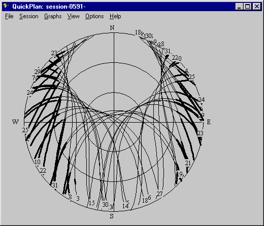 |
Now the SkyPlot shows in thick lines where satellites are not visible. |
Data dictionary
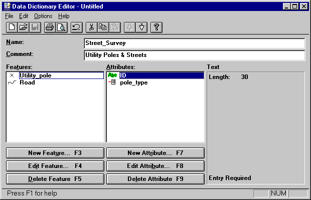
Another step in the planning process is to create a data dictionary for use in capturing attribute data for each feature. If no data dictionary is used, features will be generic points, lines, or polygons without attributes. When a data dictionary is used, and features are captured, the user has an opportunity to enter data per feature. Data dictionaries can be created for ease of use and flexibility. Data dictionaries can use text that can either be typed in or selected as menu choices. Certain GPS data loggers can also use bar-code scanners for data entry.
Here is a view of a data dictionary created to gather data about utility poles and roads. Each different feature has different attributes, and each attribute has a different data type. Utility_pole is a point feature with an ID number (typed in text) and a pole_type (menu choice).
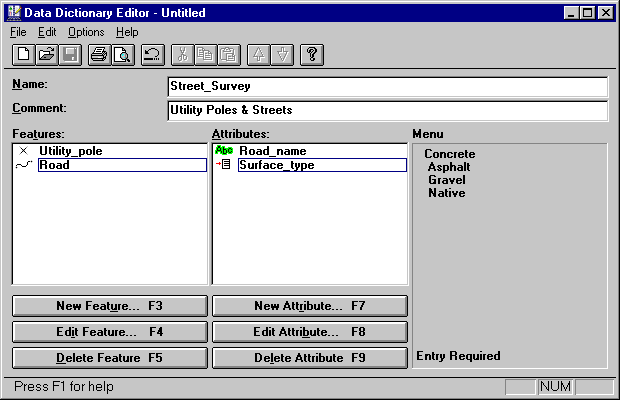
Roads are entered as line features, with names and surface types.
When the data dictionary is complete, it is uploaded to the data logger, and can then be used in conjunction with capture of locational data.
As you can see, pre-planning is a crucial step in any GPS mission.
Gathering data with a GPS is straightforward once the planning steps are done. Data are stored in individual files that can be downloaded after the data collection part of the mission is complete.
If a data dictionary has been loaded into the data logger, the user simply selects values from a menu or keys in attributes as features are caputred.
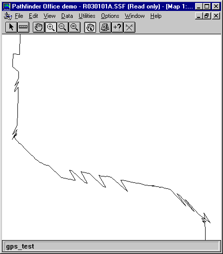
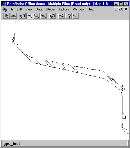
Here is a display of some uncorrected data which were captured by driving along some streets in Seattle. This file was started sometime during hour of 1:00 AM on March 1st (GMT), which is 5:00 Feb. 28 (PST). Note how the lines are not straight. This is not because the car actually followed this path, but is due to errors introduced by selective availability. These will be corrected in the next step.
Trimble rover files are automatically named with the following format:
Rmmddhh*.ssf
Where the R indicates a rover file (as opposed to B for base station file). The month, date, and hour (GMT) are stored as mmddhh, and the last wildcard is a letter from A to Z, which allows for 26 individual files every hour. The file extension ssf means Standard Storage File, which is Trimble's default binary file type. The example file we are using is r030101a.ssf. The naming convention is also used in the base station files available over the Internet, which makes it easy to find base station files for data correction.
When retreiving the base station files, we need to know the actual hours spent collecting data. Although a rover file is automatically named, if the file spans more than one hour, its name will not indicate this. However, the software contains several utilities that describe the rover file, including the time of coverage:
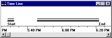
This shows that the file was opened sometime during the 5:00 hour, and closed during the 6:00 hour. Because the base station files span a single hour, starting at the 00 minute mark, we will need to retrieve the base station files for the 5:00 and 6:00 hours (01 and 02 GMT).
The US Forest Service has a web page (GLOBAL POSITIONING SYSTEM (GPS) PAGE) containing a list links to several community base stations (CBS). We should select a base station close to Seattle. The closest stations to Seattle are Portland, OR and Kettle Falls, WA. If the correction files are not available at one site, they will probably be available at the other.
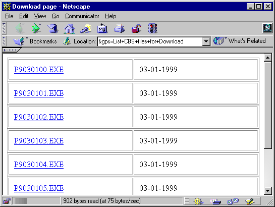
Searching the USFS Portland, OR CBS, we can find the files specifically for the time of our mission. The files we need from the CBS are P9030101.SSF and P9030102.SSF (the P is for Portland, the 9 is for 1999). Base station files are usually made available as self-extracting executables, which we have dealt with before. Once these are downloaded, they are extracted and then used in the differential correction software. Here is a list of the Portland CBS files available for our date and time.
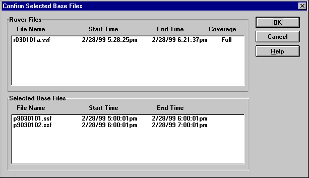
Before continuing with the correction, it is worthwhile to confirm that the time of the rover file is contained completely within the spans of the base files, which is the case here. Correcting the rover file is now as simple as clicking a few OK buttons.
Once corrected, you can see the difference immediately:
But the real question remains: how well does the corrected file fit with real world features? This question is answered once the data are exported and then imported into ArcGIS.
When the data are differentially corrected, they can be output to verious GIS formats. In our example, we are expporting the corrected file into an ArcGIS shapefile, with projection and coordinate properties as shown below. It is possible to select many different output file formats, projections, and coordinate systems. Probably the most flexible output projection/coordinate system for ArcGIS will be Lat-Long, decimal degrees, which will allow ArcGIS to project the data into other systems.
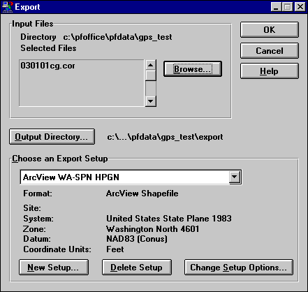
When satisfied that the correct output parameters have been selected, the OK button is clicked, and an ArcGIS shapefile is created. This method does nto require "import" to ArcGIS, since the files created are already in their native format. However, other file formats, such as the ArcInfo generate format require further processing to be converted to native formats.
Now that a shapefile has been created, we can view the data. Here is part of a digital orthophoto for Seattle, along with the uncorrected and corrected files.
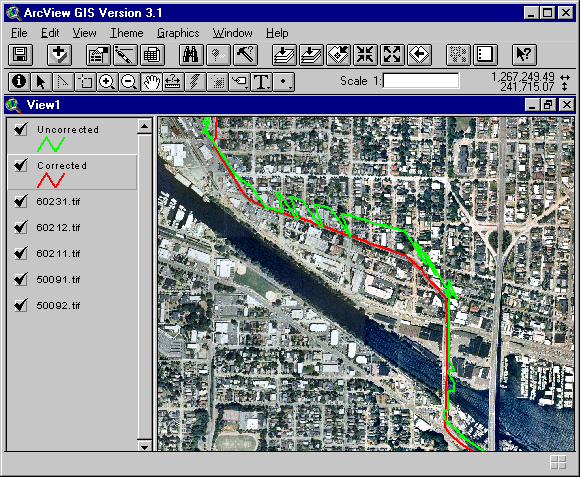
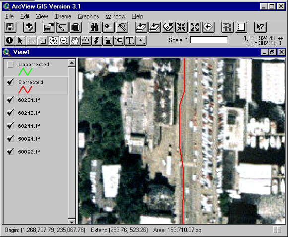
It is clearly evident that the correction did something. But how accurate are the GPS data? Let's zoom in a ways. Thsi shows a change of lanes while driving. The nominal accuracy of the handheld GPS uint used for this mission is 2-5 m, after post-processing correction. It looks like we are well within that range.
Navigation is possible using a GPS unit as the locational device.
GPS Demonstration
Return to top onward
|
|||||||||||||||||

|
The University of Washington Spatial Technology, GIS, and Remote Sensing Page is provided by the College of Forest Resources and the College of Ocean and Fisheries Sciences through Unit-Specific UIF. Site administrator: Phil Hurvitz. |
Copyright © Phil Hurvitz, 1998-2004 |
