Introduction to Geographic Information Systems in Forest Resources
| Introduction to Geographic Information Systems in Forest Resources |
|
|||||||||||||||
|
|||||||||||||||
Geographic Information Systems (GIS) are computer-based systems for the management, display, and analysis of geographic data. Before going into detailed definitions of GIS, let us look at why GIS exists, what it can do, and how it works.
Why use GIS?
GIS was originally developed as an extension of the use and analysis of the traditional paper map. The most basic form of digital map data represents the same types of data that are displayed on paper maps. Digital maps use the same measurement frameworks, and frequently also use the same representation methods (e.g., colors, classification schemes) used on paper maps.
So why have a GIS instead of using paper maps? There are many reasons, of which these are but a few:
You will see many more of the capabilities of GIS as the term progresses.
What can GIS do?
The uses of GIS are just beginning to be explored. Although GIS has been put to great use up to the present, we expect to see an explosion in the use and application of GIS in the near and distant future. Here is another list of just a few of the things GIS can do:
View some more detailed examples of what GIS can do.
Look at some maps generated from a GIS.
As you go through the term, you will have the opportunity to preform similar analytical operations as you have seen in these examples
How does GIS work?
Coordinate and tabular data
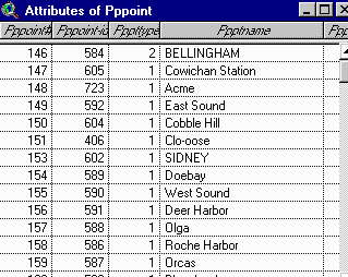
The first key component in a GIS is the spatial data. Central to the workings of GIS is the data model (discussed later in the course, in Spatial and Relational Data Models). Map data are captured in a digital format as individual features within a spatial dataset known in ArcGIS terminology as a layer. For example, the road network for the Cle Elum Nationa Forest Ranger District is digitized, and stored as a single layer. Each individual road segment is stored as a member of the coordinate part of the roads layer. In addition to digitizing the coordinate data, the GIS operator also records attribute data about each feature within a relational database table. There is a one-to-one relationship between an individual road segment in the spatial part of the layer and an individual record within the tabular part of the layer.
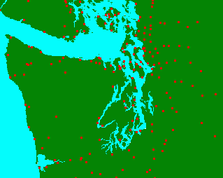
Consider this example, the populated places point layer (what you see as red dots in the image below):
 |
 |
| |
|
The layer has two parts: the database table and the coordinate features. Both parts are necessary for the functionality of the layer in the GIS. For every city point in the spatial part of the layer (what you see on the map), there is a record in the layer's attribute table. It is the linkage between the spatial and tabular data of features within layers which allows the "where" and "what" questions in the GIS. This linkage is automatically managed by the GIS software.
Coordinate registration
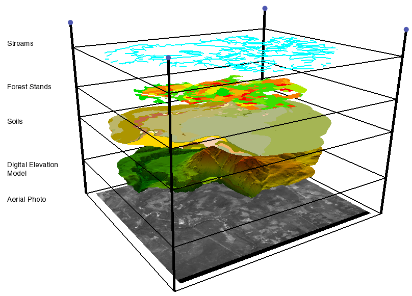
Layers in a GIS can be integrated because there exists a common coordinate framework among datasets. Consider the following image; each layer represents a different dataset capturing some characteristic of the world. The layers are displayed as a stack to show that they share the same coordinate registration framework. It is possible to combine datasets, for example, to find the unique combinations of forest stands and soils, or to "drill" through datasets, finding the value of many different layers at the same exact coordinate location. If you have a particular set of locations where groups of animals tend to congregate, you would be able to find the properties of proximity to streams, forest age, soil type, elevation, etc. at those locations.
The concept is similar to the way color printing is done; separate plates exist for each channel of color. The plates need to br registered to each other for the final print to come out properly. You can consider each layer in a GIS analogous to color separates in printing.
Computing capability
Apart from spatial datasets, the other key component in a GIS is the computer's storage and processing abilities. The computer is not smart, but it has an elephant's memory. The computer is not intelligent, but can perform predictable, programmable tasks with accuracy and speed unrivaled by even the most intelligent people. These 2 capabilities (processing power and storage power) form the foundation of how a GIS is able to function.
As you have just seen, each feature in the GIS is stored by its coordinate location. Coordinate locations are simply a series of numbers, and computers are especially good at storing and managing long lists of numbers. The relational link between the spatial and tabular parts of a layer (which is really nothing more than the association of 2 lists by a common value in each list) is also something the computer is good at handling. Computers have dropped in price simultaneously with their increase in power and speed, so advanced GIS capabilities are now available in easy-to-use software (such as ArcGIS ) on a low cost desktop computer.
Return to top | ahead to Definitions
|
|||||||||||||||

|
The University of Washington Spatial Technology, GIS, and Remote Sensing Page is supported by the School of Forest Resources |
School of Forest Resources |
